

<< Our Photo Pages >> Alta (Norway) - Rock Art in Norway in Finnmark
Submitted by greywether on Thursday, 14 July 2005 Page Views: 20214
Rock ArtSite Name: Alta (Norway)Country: Norway Fylke: Finnmark Type: Rock Art
Nearest Town: Alta
Latitude: 69.948100N Longitude: 23.183300E
Condition:
| 5 | Perfect |
| 4 | Almost Perfect |
| 3 | Reasonable but with some damage |
| 2 | Ruined but still recognisable as an ancient site |
| 1 | Pretty much destroyed, possibly visible as crop marks |
| 0 | No data. |
| -1 | Completely destroyed |
| 5 | Superb |
| 4 | Good |
| 3 | Ordinary |
| 2 | Not Good |
| 1 | Awful |
| 0 | No data. |
| 5 | Can be driven to, probably with disabled access |
| 4 | Short walk on a footpath |
| 3 | Requiring a bit more of a walk |
| 2 | A long walk |
| 1 | In the middle of nowhere, a nightmare to find |
| 0 | No data. |
| 5 | co-ordinates taken by GPS or official recorded co-ordinates |
| 4 | co-ordinates scaled from a detailed map |
| 3 | co-ordinates scaled from a bad map |
| 2 | co-ordinates of the nearest village |
| 1 | co-ordinates of the nearest town |
| 0 | no data |
Internal Links:
External Links:
I have visited· I would like to visit
DrewParsons would like to visit
Halla visited - their rating: Cond: 5 Amb: 5 Access: 4
davidmorgan have visited here
 (PID:15616)")
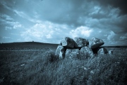
This is rock art in the land of the midnight sun - the Finnmark area of Norway. The carvings in this UNESCO World Heritage site were not discovered until 1973. It is estimated that there are between 2500 and 3000 carvings dating back to around 4200 BC. They show people, animals, boats, fish and weapons. The Visitor Centre is open until 11pm in the summer months.
You may be viewing yesterday's version of this page. To see the most up to date information please register for a free account.
 (PID:15619)")
 (PID:127870)")
 (PID:127879)")
 (PID:127882)")
 (PID:35317)")
 (PID:15643)")
 (PID:15618)")
 (PID:15617)")
 (PID:15615)")
 (PID:127869)")
 (PID:127873)")
 (PID:127872)")
 (PID:127871)")
 (PID:127876)")
 (PID:127875)")
 (PID:127874)")
 (PID:127878)")
 (PID:127877)")
 (PID:127881)")
 (PID:127880)")
 (PID:127885)")
 (PID:127884)")
 (PID:127883)")
 (PID:127887)")
These are just the first 25 photos of Alta (Norway). If you log in with a free user account you will be able to see our entire collection.
Do not use the above information on other web sites or publications without permission of the contributor.
Nearby sites
Click here to view sites on an interactive map of the areaDownload sites to:
KML (Google Earth)
GPX (GPS waypoints)
CSV (Garmin/Navman)
CSV (Excel)
To unlock full downloads you need to sign up as a Contributory Member. Otherwise downloads are limited to 50 sites.
Nearby sites listing. In the following links * = Image available
163m ESE 113° Hjemmeluft stone age settlement* Ancient Village or Settlement
5.7km NE 37° Komsa sacrificial site* Natural Stone / Erratic / Other Natural Feature
5.9km NE 41° Amtmannsnes* Carving
12.6km N 3° Djupvika sacrificial site* Natural Stone / Erratic / Other Natural Feature
12.8km ENE 68° Transfardalen* Cave or Rock Shelter
19.7km NNE 21° Kviby sacrificial site* Natural Stone / Erratic / Other Natural Feature
20.5km NNE 20° Slottsbergkjerringa* Natural Stone / Erratic / Other Natural Feature
67.5km NNE 22° Stallogargo sacrificial site* Natural Stone / Erratic / Other Natural Feature
138.7km WSW 256° Skarmunken* Natural Stone / Erratic / Other Natural Feature
161.4km WSW 242° Nordkjosbotn sacrificial site* Natural Stone / Erratic / Other Natural Feature
164.8km WSW 246° Balsfjord rock carvings* Carving
167.7km W 260° University Museum, Tromso* Museum
172.3km W 261° Håkøya* Ancient Village or Settlement
176.0km WSW 258° Skavberget* Rock Art
185.0km WSW 246° Mårfjellskardet sacrificial site* Natural Stone / Erratic / Other Natural Feature
195.7km ESE 123° Ukonkivi Round Cairn
197.2km WSW 258° Greipstad* Ancient Village or Settlement
199.5km W 262° Sandvik* Ancient Village or Settlement
199.8km W 260° Buvika* Barrow Cemetery
200.5km W 262° Brensholmen stone age settlement* Ancient Village or Settlement
201.0km W 262° Sommarøy* Ancient Village or Settlement
201.7km W 262° Brensholmen iron age settlement* Ancient Village or Settlement
244.0km WSW 237° Lapphaugen sacrificial site* Natural Stone / Erratic / Other Natural Feature
244.9km WSW 243° Andasteinen* Natural Stone / Erratic / Other Natural Feature
247.6km WSW 241° Lavangen* Barrow Cemetery


 We would like to know more about this location. Please feel free to add a brief description and any relevant information in your own language.
 Wir möchten mehr über diese Stätte erfahren. Bitte zögern Sie nicht, eine kurze Beschreibung und relevante Informationen in Deutsch hinzuzufügen.
 Nous aimerions en savoir encore un peu sur les lieux. S'il vous plaît n'hesitez pas à ajouter une courte description et tous les renseignements pertinents dans votre propre langue.
 Quisieramos informarnos un poco más de las lugares. No dude en añadir una breve descripción y otros datos relevantes en su propio idioma.