

<< Our Photo Pages >> Solberg - Rock Art in Norway
Submitted by greywether on Thursday, 14 July 2005 Page Views: 13191
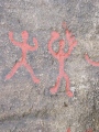
Rock ArtSite Name: SolbergCountry: Norway Type: Rock Art
Nearest Town: Skjeberg Nearest Village: Skjeberg
Latitude: 59.214780N Longitude: 11.167610E
Condition:
| 5 | Perfect |
| 4 | Almost Perfect |
| 3 | Reasonable but with some damage |
| 2 | Ruined but still recognisable as an ancient site |
| 1 | Pretty much destroyed, possibly visible as crop marks |
| 0 | No data. |
| -1 | Completely destroyed |
| 5 | Superb |
| 4 | Good |
| 3 | Ordinary |
| 2 | Not Good |
| 1 | Awful |
| 0 | No data. |
| 5 | Can be driven to, probably with disabled access |
| 4 | Short walk on a footpath |
| 3 | Requiring a bit more of a walk |
| 2 | A long walk |
| 1 | In the middle of nowhere, a nightmare to find |
| 0 | No data. |
| 5 | co-ordinates taken by GPS or official recorded co-ordinates |
| 4 | co-ordinates scaled from a detailed map |
| 3 | co-ordinates scaled from a bad map |
| 2 | co-ordinates of the nearest village |
| 1 | co-ordinates of the nearest town |
| 0 | no data |
Internal Links:
External Links:
I have visited· I would like to visit
Tonnox visited on 25th Jul 2022 - their rating: Cond: 5 Amb: 5 Access: 4
DrewParsons Martin_L have visited here
")
In the Østfold region near the border with Sweden is the route 110 between Skjeberg and Fredrikstad known as "The Prehistoric Road" (Oldtidsveien) due to the large number of ancient sites along the route.
It is particularly rich in rock art and an English language booklet The Rock Carving Tour, Østfold gives details of all the sites including the non rock art ones. The route can conveniently be added to the Swedish sites covered in the more extensive Rock Carving Tour, Bohuslän (English booklet also available). All these sites are well-signposted with parking and interpretation boards.
The first site on the Østfold tour is Solberg with its two splendid panels of rockart.
You may be viewing yesterday's version of this page. To see the most up to date information please register for a free account.
")
")
")
")
")
")
")
")
")
")
")
")
")
")
")
")
")
")
")
")
")
")
")
")
These are just the first 25 photos of Solberg. If you log in with a free user account you will be able to see our entire collection.
Do not use the above information on other web sites or publications without permission of the contributor.
Click here to see more info for this site
Nearby sites
Click here to view sites on an interactive map of the areaKey: Red: member's photo, Blue: 3rd party photo, Yellow: other image, Green: no photo - please go there and take one, Grey: site destroyed
Download sites to:
KML (Google Earth)
GPX (GPS waypoints)
CSV (Garmin/Navman)
CSV (Excel)
To unlock full downloads you need to sign up as a Contributory Member. Otherwise downloads are limited to 50 sites.
Turn off the page maps and other distractions
Nearby sites listing. In the following links * = Image available
1.2km SW 216° Solbergfeltet* Rock Art
1.5km WSW 244° Kongegraven* Cairn
1.6km SSW 192° Kaarehornæs* Stone Circle
1.7km SSW 200° Kapellangården* Stone Circle
1.7km ESE 116° Guslund Nedre* Ancient Village or Settlement
1.7km ESE 109° Åsgarden cairn* Cairn
1.9km NE 34° Skjeberg Kirke* Stone Circle
2.0km WSW 247° Tyskerhøla* Stone Circle
2.1km WSW 244° Gunnarstorp-Skole-Steinsettingen* Stone Circle
2.1km W 272° Gunnarstorp Standing Stones* Standing Stones
2.2km N 9° Vestre Foss* Rock Art
2.2km SSW 193° Hornnesveien Østre* Stone Circle
2.2km ESE 105° Løkke* Cairn
2.3km W 265° Gunnarstorp Cairn* Cairn
2.6km W 271° Skjeltorpdyssen* Burial Chamber or Dolmen
2.9km SSE 157° Høysand* Stone Circle
2.9km W 277° Stabbetorp mound* Round Barrow(s)
3.2km NNW 340° Pyntelund/Bjørnstadskipet* Rock Art
3.5km W 269° Store-Dal Gravfelt* Barrow Cemetery
3.5km NE 37° Rokkeveien-Vik Stone Circles* Stone Circle
3.6km NE 46° Steinane* Cairn
3.6km ENE 60° Rønneld stone circle* Stone Circle
3.6km WNW 286° Storedal Kultursenter* Modern Stone Circle etc
3.6km NE 38° Vik Stone Rings* Stone Circle
3.7km ENE 58° Rønnild Barrow Cemetery* Barrow Cemetery
View more nearby sites and additional images


 We would like to know more about this location. Please feel free to add a brief description and any relevant information in your own language.
 Wir möchten mehr über diese Stätte erfahren. Bitte zögern Sie nicht, eine kurze Beschreibung und relevante Informationen in Deutsch hinzuzufügen.
 Nous aimerions en savoir encore un peu sur les lieux. S'il vous plaît n'hesitez pas à ajouter une courte description et tous les renseignements pertinents dans votre propre langue.
 Quisieramos informarnos un poco más de las lugares. No dude en añadir una breve descripción y otros datos relevantes en su propio idioma.