<< Text Pages >> Deuvels Brotschapp - Natural Stone / Erratic / Other Natural Feature in Germany in Lower Saxony, Bremen
Submitted by RunaStera on Sunday, 17 April 2005 Page Views: 2750
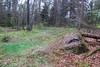
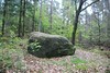
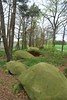
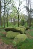
Natural PlacesSite Name: Deuvels Brotschapp Alternative Name: Opferstein Dalumer Brotschapp, Daolmer BrotschappCountry: Germany Land: Lower Saxony, Bremen Type: Natural Stone / Erratic / Other Natural Feature
Nearest Town: Bippen Nearest Village: Dalum
Latitude: 52.551111N Longitude: 7.748333E
Condition:
| 5 | Perfect |
| 4 | Almost Perfect |
| 3 | Reasonable but with some damage |
| 2 | Ruined but still recognisable as an ancient site |
| 1 | Pretty much destroyed, possibly visible as crop marks |
| 0 | No data. |
| -1 | Completely destroyed |
| 5 | Superb |
| 4 | Good |
| 3 | Ordinary |
| 2 | Not Good |
| 1 | Awful |
| 0 | No data. |
| 5 | Can be driven to, probably with disabled access |
| 4 | Short walk on a footpath |
| 3 | Requiring a bit more of a walk |
| 2 | A long walk |
| 1 | In the middle of nowhere, a nightmare to find |
| 0 | No data. |
| 5 | co-ordinates taken by GPS or official recorded co-ordinates |
| 4 | co-ordinates scaled from a detailed map |
| 3 | co-ordinates scaled from a bad map |
| 2 | co-ordinates of the nearest village |
| 1 | co-ordinates of the nearest town |
| 0 | no data |
Internal Links:
External Links:
Natural Stone / Glacial Erratic in Lower Saxony, Bremen
You may be viewing yesterday's version of this page. To see the most up to date information please register for a free account.
Do not use the above information on other web sites or publications without permission of the contributor.
Nearby Images from Flickr

The above images may not be of the site on this page, but were taken nearby. They are loaded from Flickr so please click on them for image credits.
Click here to see more info for this site
Nearby sites
Click here to view sites on an interactive map of the areaKey: Red: member's photo, Blue: 3rd party photo, Yellow: other image, Green: no photo - please go there and take one, Grey: site destroyed
Download sites to:
KML (Google Earth)
GPX (GPS waypoints)
CSV (Garmin/Navman)
CSV (Excel)
To unlock full downloads you need to sign up as a Contributory Member. Otherwise downloads are limited to 50 sites.
Turn off the page maps and other distractions
Nearby sites listing. In the following links * = Image available
189m NNW 349° Hexentanzplatz Dalum Chambered Tomb
737m WSW 255° Großsteingrab Dalum* Chambered Tomb
955m NE 42° Teufelsstein (Klein Bokern) Natural Stone / Erratic / Other Natural Feature
1.2km SSW 200° Pfaohlenstein Stone Circle
1.6km SSE 148° Steingrab Klein Bokern* Chambered Tomb
2.4km W 274° Lonnerbecke Hügelgrab 1 Round Barrow(s)
2.6km E 88° Basum Hügelgrab 3 Round Barrow(s)
3.2km NE 34° Restruper Näpfchenstein* Rock Art
3.2km NE 35° Restruper Großsteingrab* Chambered Tomb
4.7km NNE 27° Hekese Grabhügelfeld* Barrow Cemetery
4.8km NNE 26° Hekese Grab A* Chambered Tomb
4.8km NNE 26° Hekese Steinsetzung* Stone Row / Alignment
4.8km NNE 25° Hekese Grab B* Chambered Tomb
5.1km ENE 62° Eggermuehlen Huegelgrab (1)* Round Barrow(s)
5.3km NE 42° Bockraden Modern Menhir* Modern Stone Circle etc
5.4km W 261° Lonnerbecke Hügelgrab 2 Round Barrow(s)
5.4km NE 42° Hünengrab Bockraden* Chambered Tomb
5.6km NE 54° Basum Huegelgrab 1 Round Barrow(s)
5.9km NE 53° Basum Hügelgräberfeld Barrow Cemetery
6.0km NE 50° Basum Hügelgrab 2 Round Barrow(s)
6.2km SSE 147° Plaggenschale Hügelgräberfeld Barrow Cemetery
6.6km E 79° Holsten Huegelgraeber* Round Barrow(s)
8.5km E 92° Nonnenberg Huegelgrab* Round Barrow(s)
8.8km S 185° Höckel Hügelgrab Round Barrow(s)
9.1km ESE 114° Tütingen Hügelgräberfeld Barrow Cemetery
View more nearby sites and additional images


 We would like to know more about this location. Please feel free to add a brief description and any relevant information in your own language.
 Wir möchten mehr über diese Stätte erfahren. Bitte zögern Sie nicht, eine kurze Beschreibung und relevante Informationen in Deutsch hinzuzufügen.
 Nous aimerions en savoir encore un peu sur les lieux. S'il vous plaît n'hesitez pas à ajouter une courte description et tous les renseignements pertinents dans votre propre langue.
 Quisieramos informarnos un poco más de las lugares. No dude en añadir una breve descripción y otros datos relevantes en su propio idioma.