 with our Megalithic Portal iPhone app")


<< Our Photo Pages >> Shipton Barrow - Barrow Cemetery in England in Oxfordshire
Submitted by Celia_Haddon on Wednesday, 03 November 2004 Page Views: 6449
Neolithic and Bronze AgeSite Name: Shipton BarrowCountry: England County: Oxfordshire Type: Barrow Cemetery
Nearest Village: Shipton
Map Ref: SP269155
Latitude: 51.837465N Longitude: 1.610988W
Condition:
| 5 | Perfect |
| 4 | Almost Perfect |
| 3 | Reasonable but with some damage |
| 2 | Ruined but still recognisable as an ancient site |
| 1 | Pretty much destroyed, possibly visible as crop marks |
| 0 | No data. |
| -1 | Completely destroyed |
| 5 | Superb |
| 4 | Good |
| 3 | Ordinary |
| 2 | Not Good |
| 1 | Awful |
| 0 | No data. |
| 5 | Can be driven to, probably with disabled access |
| 4 | Short walk on a footpath |
| 3 | Requiring a bit more of a walk |
| 2 | A long walk |
| 1 | In the middle of nowhere, a nightmare to find |
| 0 | No data. |
| 5 | co-ordinates taken by GPS or official recorded co-ordinates |
| 4 | co-ordinates scaled from a detailed map |
| 3 | co-ordinates scaled from a bad map |
| 2 | co-ordinates of the nearest village |
| 1 | co-ordinates of the nearest town |
| 0 | no data |
Be the first person to rate this site - see the 'Contribute!' box in the right hand menu.
Internal Links:
External Links:
I have visited· I would like to visit
h_fenton has visited here
")
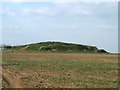
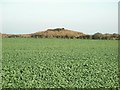
The bronze age barrow is a stone and earth cairn. The burial mound, or Saxon hlaew, is an earth and stone mound constructed in two tiers. There were human bones in the top of the mound which were partially excavated in l976. With them was an iron buckle or the early medieval or dark ages.
The bowl barrow has been reduced by cultivation. A three sided enclosure, of the kind associated with the Saxon hlaew, has an open fourth side including the bronze age barrow. The sides are 63 m. long with a 3m wide and 1m high bank and ditch which is 2m wide. The field layout follows the N and W sides, while the S is levelled by cultivation.
You may be viewing yesterday's version of this page. To see the most up to date information please register for a free account.
")
")
")
Do not use the above information on other web sites or publications without permission of the contributor.
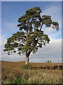
Nearby Images from Geograph Britain and Ireland:
©2011(licence)
©2009(licence)
©2006(licence)
©2009(licence)
©2009(licence)
The above images may not be of the site on this page, they are loaded from Geograph.
Please Submit an Image of this site or go out and take one for us!
Click here to see more info for this site
Nearby sites
Key: Red: member's photo, Blue: 3rd party photo, Yellow: other image, Green: no photo - please go there and take one, Grey: site destroyed
Download sites to:
KML (Google Earth)
GPX (GPS waypoints)
CSV (Garmin/Navman)
CSV (Excel)
To unlock full downloads you need to sign up as a Contributory Member. Otherwise downloads are limited to 50 sites.
Turn off the page maps and other distractions
Nearby sites listing. In the following links * = Image available
2.9km SE 124° Ladihame* Long Barrow (SP293139)
3.4km NE 56° Coldwell Bridge Long Barrow 2* Long Barrow (SP29751745)
3.7km NE 55° Ascott under Wychwood* Chambered Tomb (SP299176)
5.3km ENE 68° High Lodge Tumuli Round Barrow(s) (SP318175)
5.4km ENE 56° Smallstones Farm Long Barrow (SP31411852)
5.7km NW 315° Idbury Camp* Hillfort (SP22871954)
5.8km SSE 160° Asthall Barrow* Barrow Cemetery (SP289101)
6.1km WNW 303° Fifield Chambered Cairn (SP218188)
6.1km E 81° Slatepits Copse* Chambered Tomb (SP329165)
6.3km NNE 27° Lyneham Long Barrow* Long Barrow (SP29752107)
6.4km ENE 78° Churchill Copse* Long Barrow (SP33161685)
6.6km NNE 27° Lyneham Camp* Hillfort (SP299214)
7.8km NNE 16° Old Vicarage* Standing Stone (Menhir) (SP290230)
8.0km ESE 122° Churchill Plain Chambered Tomb (SP33711129)
8.5km NW 309° Wyck Beacon bowl barrow* Round Barrow(s) (SP20182078)
8.7km N 10° Churchill* Stone Circle (SP284241)
8.8km NNE 32° Knollbury Enclosure* Ancient Village or Settlement (SP316230)
9.0km ENE 69° Cornbury Park Round Barrow(s) (SP35311878)
9.3km WSW 250° Windrush Camp* Hillfort (SP181123)
9.8km ENE 70° Sturt Henge* Modern Stone Circle etc (SP36111899)
10.1km NW 320° Icomb Camp* Hillfort (SP20352315)
10.5km NNE 14° Churchill Standing Stone* Standing Stone (Menhir) (SP29372568)
10.5km E 94° The Lady's Well (Oxfordshire)* Holy Well or Sacred Spring (SP374148)
10.7km NE 41° Hawk Stone* Standing Stone (Menhir) (SP33922354)
10.8km WNW 300° Salmonsbury Camp* Hillfort (SP175208)
View more nearby sites and additional images


 We would like to know more about this location. Please feel free to add a brief description and any relevant information in your own language.
 Wir möchten mehr über diese Stätte erfahren. Bitte zögern Sie nicht, eine kurze Beschreibung und relevante Informationen in Deutsch hinzuzufügen.
 Nous aimerions en savoir encore un peu sur les lieux. S'il vous plaît n'hesitez pas à ajouter une courte description et tous les renseignements pertinents dans votre propre langue.
 Quisieramos informarnos un poco más de las lugares. No dude en añadir una breve descripción y otros datos relevantes en su propio idioma.