

<< Our Photo Pages >> Hawk Stone - Standing Stone (Menhir) in England in Oxfordshire
Submitted by Celia_Haddon on Tuesday, 24 September 2002 Page Views: 19813
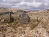
Neolithic and Bronze AgeSite Name: Hawk Stone Alternative Name: HawkstoneCountry: England County: Oxfordshire Type: Standing Stone (Menhir)
Nearest Town: Chipping Norton Nearest Village: Chadlington
Map Ref: SP33922354 Landranger Map Number: OL45
Latitude: 51.909368N Longitude: 1.508319W
Condition:
| 5 | Perfect |
| 4 | Almost Perfect |
| 3 | Reasonable but with some damage |
| 2 | Ruined but still recognisable as an ancient site |
| 1 | Pretty much destroyed, possibly visible as crop marks |
| 0 | No data. |
| -1 | Completely destroyed |
| 5 | Superb |
| 4 | Good |
| 3 | Ordinary |
| 2 | Not Good |
| 1 | Awful |
| 0 | No data. |
| 5 | Can be driven to, probably with disabled access |
| 4 | Short walk on a footpath |
| 3 | Requiring a bit more of a walk |
| 2 | A long walk |
| 1 | In the middle of nowhere, a nightmare to find |
| 0 | No data. |
| 5 | co-ordinates taken by GPS or official recorded co-ordinates |
| 4 | co-ordinates scaled from a detailed map |
| 3 | co-ordinates scaled from a bad map |
| 2 | co-ordinates of the nearest village |
| 1 | co-ordinates of the nearest town |
| 0 | no data |
Internal Links:
External Links:
I have visited· I would like to visit
SimonBlackmore visited on 25th Jan 2020 - their rating: Cond: 2 Access: 5
Catrinm visited on 30th Sep 2017 - their rating: Cond: 4 Amb: 3 Access: 4
NickyD visited - their rating: Amb: 4 Access: 3
ChristopherJones visited - their rating: Cond: 4 Amb: 5 Access: 4 It can't be missed, it is in the second field from the footpath near Dean.
h_fenton hamish ocifant have visited here
Average ratings for this site from all visit loggers: Condition: 3.33 Ambience: 4 Access: 4
")
It is first illustrated and named on a local map of the region in 1743 CE, and has fortunately managed to escape the intense agricultural ravages endemic to this part of the country. This impressive weather-worn eight-foot tall standing stone stands aloft in the centre of a field due west of the road between Chalford Green and Dean.
In local folklore and some earlier archaeologists, the Hawk Stone formed an integral part of a stone circle here, but there is little known evidence to substantiate this. In Thorn Graves' (1980) dowsing experiments at the Rollright circle, he found what he described as an 'overground' linking the Circle to the Hawk Stone, but no other connecting sites are known along this line.
Interestingly one legend surrounding the monolith tells how this monolith was thrown, or dragged, across the land by a old witch or hag, though we are not told from where a motif found in connection with spirit lines across the country.
In Corbett's History of Spelsbury (1962) the author some of the folklore spoken of our holed Hawk Stone by one Mr Caleb Lainchbury who "said the cleft at the top of the Hawk Stone at Dean was supposed to of been made by the chains of the witches who were tied to it and burnt. As witches seem to have been extremely rare in Oxfordshire it cannot have been a very common practise to burn them at Dean; but there may indeed have been some kind of fire ceremonies near the stone.
In name, Hawk stone may come from a fancied resemblence to a Hawk, or because there very often are hawks hovering over those upland fields: or it may simply be a corruption of 'Hoar' meaning old.
In pagan Celtic Britain hawks played a not inconsiderable part in their shamanic lore and,according to Ross [1967] were "malevolent birds". This evidently important and visually impressive monolith plays a substantial part in an incredibly precise alignment (ley) running roughly east-west across the landscape. At first I [TW] thought it to have gone unnoticed but later we later found a reference to the same alignment in an early copy of The Ley Hunter [Cooper 1979]. It links up with other important megalithic sites, such as the Hoar Stones at Enstone, Buswell's thicket, and the ancient Sarsden Cross . To all lovers of megalithic sites, we highly recommend a visit here!
Text from "The Old Stones of Rollright and District" by Paul Bennett and Tom Wilson, used with thanks. Also see Paul's entry on The Northern Antiquarian - the Hawk Stone, Spelsbury, Oxfordshire.
You may be viewing yesterday's version of this page. To see the most up to date information please register for a free account.
")
")
")
")
")
")
")
")
")
")
")
")
")
 (PID:192174)")
")
")
")
")
")
")
")
")
")
Do not use the above information on other web sites or publications without permission of the contributor.
Click here to see more info for this site
Nearby sites
Key: Red: member's photo, Blue: 3rd party photo, Yellow: other image, Green: no photo - please go there and take one, Grey: site destroyed
Download sites to:
KML (Google Earth)
GPX (GPS waypoints)
CSV (Garmin/Navman)
CSV (Excel)
To unlock full downloads you need to sign up as a Contributory Member. Otherwise downloads are limited to 50 sites.
Turn off the page maps and other distractions
Nearby sites listing. In the following links * = Image available
2.4km WSW 257° Knollbury Enclosure* Ancient Village or Settlement (SP316230)
2.5km SE 126° Thor Stone* Standing Stone (Menhir) (SP35932208)
2.6km SE 129° Thorsbrook Spring* Holy Well or Sacred Spring (SP360219)
3.9km E 87° Hoar Stone at Enstone* Chambered Tomb (SP37792375)
4.4km NW 322° New Street Stone* Holed Stone (SP312270)
4.5km NW 320° Serpent's Well (Chipping Norton) Holy Well or Sacred Spring (SP310270)
4.5km WSW 242° Lyneham Camp* Hillfort (SP299214)
4.8km WSW 240° Lyneham Long Barrow* Long Barrow (SP29752107)
4.9km W 264° Old Vicarage* Standing Stone (Menhir) (SP290230)
5.0km SSE 164° Cornbury Park Round Barrow(s) (SP35311878)
5.0km NNW 345° Druids Barrow Round Barrow(s) (SP32612835)
5.0km WNW 296° Churchill Standing Stone* Standing Stone (Menhir) (SP29372568)
5.0km SSE 155° Sturt Henge* Modern Stone Circle etc (SP36111899)
5.1km ESE 122° Model Farm Ancient Village or Settlement (SP383209)
5.5km W 276° Churchill* Stone Circle (SP284241)
5.6km SSW 207° Smallstones Farm Long Barrow (SP31411852)
6.4km SSW 200° High Lodge Tumuli Round Barrow(s) (SP318175)
6.6km ESE 108° Home Farm Ancient Village or Settlement (SP402215)
6.7km S 187° Churchill Copse* Long Barrow (SP33161685)
6.9km NW 311° Salford Cross Cup Marks (Salford) Ancient Cross (SP2864428058)
7.1km S 189° Slatepits Copse* Chambered Tomb (SP329165)
7.2km SW 214° Ascott under Wychwood* Chambered Tomb (SP299176)
7.4km SW 215° Coldwell Bridge Long Barrow 2* Long Barrow (SP29751745)
7.8km ESE 106° Grimsdyke Farm Ancient Village or Settlement (SP41402141)
7.9km ESE 111° Out Wood & Berrings Wood Ancient Village or Settlement (SP413208)
View more nearby sites and additional images


 We would like to know more about this location. Please feel free to add a brief description and any relevant information in your own language.
 Wir möchten mehr über diese Stätte erfahren. Bitte zögern Sie nicht, eine kurze Beschreibung und relevante Informationen in Deutsch hinzuzufügen.
 Nous aimerions en savoir encore un peu sur les lieux. S'il vous plaît n'hesitez pas à ajouter une courte description et tous les renseignements pertinents dans votre propre langue.
 Quisieramos informarnos un poco más de las lugares. No dude en añadir una breve descripción y otros datos relevantes en su propio idioma.