 with our Megalithic Portal iPhone app")

<< Our Photo Pages >> Raecleughhead - Hillfort in Scotland in Scottish Borders
Submitted by mafenty on Thursday, 03 April 2008 Page Views: 5936
Iron Age and Later PrehistorySite Name: RaecleughheadCountry: Scotland
NOTE: This site is 1.4 km away from the location you searched for.
County: Scottish Borders Type: Hillfort
Nearest Town: Duns Nearest Village: Longformacus
Map Ref: NT74355351
Latitude: 55.774234N Longitude: 2.410447W
Condition:
| 5 | Perfect |
| 4 | Almost Perfect |
| 3 | Reasonable but with some damage |
| 2 | Ruined but still recognisable as an ancient site |
| 1 | Pretty much destroyed, possibly visible as crop marks |
| 0 | No data. |
| -1 | Completely destroyed |
| 5 | Superb |
| 4 | Good |
| 3 | Ordinary |
| 2 | Not Good |
| 1 | Awful |
| 0 | No data. |
| 5 | Can be driven to, probably with disabled access |
| 4 | Short walk on a footpath |
| 3 | Requiring a bit more of a walk |
| 2 | A long walk |
| 1 | In the middle of nowhere, a nightmare to find |
| 0 | No data. |
| 5 | co-ordinates taken by GPS or official recorded co-ordinates |
| 4 | co-ordinates scaled from a detailed map |
| 3 | co-ordinates scaled from a bad map |
| 2 | co-ordinates of the nearest village |
| 1 | co-ordinates of the nearest town |
| 0 | no data |
Internal Links:
External Links:
")
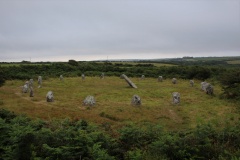
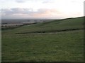
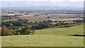
Bi- or tri-vallate Hillfort. Superb views over to Cheviots and to Lammermuirs A further Hillfort can be seen to the south, less than half a kilometre away.
For more information see Canmore ID 58705, which adds this is: "a roughly circular fort, measuring about 66m by 57m internally. Its defences comprise double ditches with a medial rampart, and there is a possible palisade trench along the inner lip of the inner ditch. The original entrance was probably on the East but it is blocked by a later bank which encloses the whole fort."
You may be viewing yesterday's version of this page. To see the most up to date information please register for a free account.
")
")
Do not use the above information on other web sites or publications without permission of the contributor.
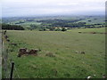
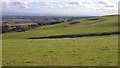
Nearby Images from Geograph Britain and Ireland:
©2006(licence)
©2018(licence)
©2008(licence)
©2009(licence)
©2018(licence)
The above images may not be of the site on this page, they are loaded from Geograph.
Please Submit an Image of this site or go out and take one for us!
Click here to see more info for this site
Nearby sites
Key: Red: member's photo, Blue: 3rd party photo, Yellow: other image, Green: no photo - please go there and take one, Grey: site destroyed
Download sites to:
KML (Google Earth)
GPX (GPS waypoints)
CSV (Garmin/Navman)
CSV (Excel)
To unlock full downloads you need to sign up as a Contributory Member. Otherwise downloads are limited to 50 sites.
Turn off the page maps and other distractions
Nearby sites listing. In the following links * = Image available
4.2km E 85° Duns Mercat Cross* Ancient Cross (NT7855253883)
4.3km ENE 74° Duns Law Hillfort* Hillfort (NT78505468)
4.9km NE 51° Cumledge Cist* Cist (NT782566)
5.4km SSW 203° Herriot's Dyke* Misc. Earthwork (NT722485)
5.9km NE 56° Primrose Hill Fort* Hillfort (NT79285682)
6.6km SSW 199° Piersknowe Plantation* Cairn (NT72174726)
6.6km NNE 19° Cockburn Law Hillfort* Hillfort (NT76565975)
6.7km NNE 22° Cockburn Law Settlement* Ancient Village or Settlement (NT76915969)
6.9km ENE 66° Broomhouse Souterrain* Souterrain (Fogou, Earth House) (NT80675629)
7.1km ENE 73° Manderston cist* Cist (NT81125555)
7.4km NNE 23° Edin's Hall* Broch or Nuraghe (NT7724060310)
7.9km NE 41° Preston Cleugh Fort* Hillfort (NT79555941)
8.2km NNE 32° Elba copper mines* Ancient Mine, Quarry or other Industry (NT787605)
8.7km ENE 74° Edrom Sculptured Stone (NT828558)
9.4km WSW 236° Harelaw* Misc. Earthwork (NT66444834)
9.4km N 4° Shannabank Hill Hillfort (NT75096292)
9.4km NE 42° Drakemire hillforts* Hillfort (NT80726051)
11.4km ENE 65° The Pech Stane* Standing Stone (Menhir) (NT84685831)
11.4km S 171° Crosshall Cross* Ancient Cross (NT76064223)
11.7km W 272° Kingside Hill (Cranshaws) Stone Circle (NT62635403)
12.0km W 275° Twin Law Cairns* Cairn (NT624547)
12.4km NW 320° Kilmade Hillfort* Hillfort (NT66456315)
13.3km NNE 30° Grantshouse Rock Art* Rock Art (NT8165)
13.3km WNW 294° Mutiny Stones* Cairn (NT62255902)
14.1km NW 313° Penshiel Grange Stone Circle* Stone Circle (NT64016317)
View more nearby sites and additional images


 We would like to know more about this location. Please feel free to add a brief description and any relevant information in your own language.
 Wir möchten mehr über diese Stätte erfahren. Bitte zögern Sie nicht, eine kurze Beschreibung und relevante Informationen in Deutsch hinzuzufügen.
 Nous aimerions en savoir encore un peu sur les lieux. S'il vous plaît n'hesitez pas à ajouter une courte description et tous les renseignements pertinents dans votre propre langue.
 Quisieramos informarnos un poco más de las lugares. No dude en añadir una breve descripción y otros datos relevantes en su propio idioma.