 with our Megalithic Portal iPhone app")

<< Text Pages >> Grabhügelfeld Bühlheimer Heide - Barrow Cemetery in Germany in North Rhine-Westphalia
Submitted by Harald_Platta on Sunday, 09 June 2019 Page Views: 680
Neolithic and Bronze AgeSite Name: Grabhügelfeld Bühlheimer HeideCountry: Germany
NOTE: This site is 4.927 km away from the location you searched for.
Land: North Rhine-Westphalia Type: Barrow Cemetery
Nearest Town: Lichtenau
Latitude: 51.606500N Longitude: 8.954750E
Condition:
| 5 | Perfect |
| 4 | Almost Perfect |
| 3 | Reasonable but with some damage |
| 2 | Ruined but still recognisable as an ancient site |
| 1 | Pretty much destroyed, possibly visible as crop marks |
| 0 | No data. |
| -1 | Completely destroyed |
| 5 | Superb |
| 4 | Good |
| 3 | Ordinary |
| 2 | Not Good |
| 1 | Awful |
| 0 | No data. |
| 5 | Can be driven to, probably with disabled access |
| 4 | Short walk on a footpath |
| 3 | Requiring a bit more of a walk |
| 2 | A long walk |
| 1 | In the middle of nowhere, a nightmare to find |
| 0 | No data. |
| 5 | co-ordinates taken by GPS or official recorded co-ordinates |
| 4 | co-ordinates scaled from a detailed map |
| 3 | co-ordinates scaled from a bad map |
| 2 | co-ordinates of the nearest village |
| 1 | co-ordinates of the nearest town |
| 0 | no data |
Internal Links:
External Links:
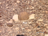
The Grabhügelfeld Bühlheimer Heide is a barrow cemetery in the Bühlheim heath in Lichtenau (North-Rhine Westphalia/Germany). It consisits of at least 42 barrows, which have been speculated to date from the Bronze Age.
Reference:
[01] Lange, W.R.: Hügelgräber im Naturschutzgebiet Bülheimer Heide. In: Römisch-Germanisches Zentralmuseum Mainz (Hg.): Paderborner Hochfläche. Paderborn. Büren. Salzkotten. (= Römisch-Germanisches Zentralmuseum Mainz (Hg.): Führer zu vor- und frühgeschichtlichen Denkmälern. Bd. 20 (1971).
You may be viewing yesterday's version of this page. To see the most up to date information please register for a free account.
Do not use the above information on other web sites or publications without permission of the contributor.
Nearby Images from Flickr


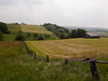
The above images may not be of the site on this page, but were taken nearby. They are loaded from Flickr so please click on them for image credits.
Click here to see more info for this site
Nearby sites
Click here to view sites on an interactive map of the areaKey: Red: member's photo, Blue: 3rd party photo, Yellow: other image, Green: no photo - please go there and take one, Grey: site destroyed
Download sites to:
KML (Google Earth)
GPX (GPS waypoints)
CSV (Garmin/Navman)
CSV (Excel)
To unlock full downloads you need to sign up as a Contributory Member. Otherwise downloads are limited to 50 sites.
Turn off the page maps and other distractions
Nearby sites listing. In the following links * = Image available
3.1km ESE 104° Kleiner Herrgott* Ancient Cross
3.4km E 97° Behmburg* Hillfort
3.7km ENE 73° St. Michaels Born* Holy Well or Sacred Spring
3.9km E 96° Drudenhöhle* Cave or Rock Shelter
3.9km E 96° Opferstein am Hexenberg* Natural Stone / Erratic / Other Natural Feature
3.9km E 96° Opferstein Fauler Jäger* Natural Stone / Erratic / Other Natural Feature
4.2km E 93° Teufelssteine (Willebadessen)* Natural Stone / Erratic / Other Natural Feature
4.8km NE 49° Eggequelle* Holy Well or Sacred Spring
5.2km SSE 149° Opferstein Hardehausen Natural Stone / Erratic / Other Natural Feature
7.3km NNE 24° Grabhügel Bollberg Round Barrow(s)
7.7km N 11° Teufelsküche (Neuenheerse) Natural Stone / Erratic / Other Natural Feature
9.8km W 262° Atteln 1* Chambered Tomb
9.9km SE 143° Kellberg Huegelgraeber (1)* Cairn
10.3km W 265° Atteln Galeriegrab (2)* Burial Chamber or Dolmen
10.8km SE 137° Weisses Holz Huegelgrab (1)* Cairn
10.9km SE 136° Erdwerk von Rimbeck* Misc. Earthwork
10.9km SE 137° Rimbeck* Passage Grave
13.1km W 268° Henglarn Steinkammergrab (2)* Chambered Tomb
13.3km W 270° Henglarn Galeriegrab 1* Chambered Tomb
13.4km ESE 118° Linienbandkeramisches Gräberfeld von Warburg-Hohenwepel Barrow Cemetery
14.7km ESE 123° Hohenwepel Galeriegrab Chambered Tomb
14.8km WNW 282° Etteln Steingrab* Chambered Tomb
15.5km WNW 283° Wallburg Gellinghausen* Hillfort
16.2km WNW 292° Storchenkolk* Holy Well or Sacred Spring
16.5km WNW 283° Grabhügel am Burgweg Round Barrow(s)
View more nearby sites and additional images


 We would like to know more about this location. Please feel free to add a brief description and any relevant information in your own language.
 Wir möchten mehr über diese Stätte erfahren. Bitte zögern Sie nicht, eine kurze Beschreibung und relevante Informationen in Deutsch hinzuzufügen.
 Nous aimerions en savoir encore un peu sur les lieux. S'il vous plaît n'hesitez pas à ajouter une courte description et tous les renseignements pertinents dans votre propre langue.
 Quisieramos informarnos un poco más de las lugares. No dude en añadir una breve descripción y otros datos relevantes en su propio idioma.