

<< Our Photo Pages >> Ankara Tumuli - Round Barrow(s) in Turkey
Submitted by AlexHunger on Monday, 26 March 2007 Page Views: 3773
Neolithic and Bronze AgeSite Name: Ankara Tumuli Alternative Name: Ankara Phrygian NecropolisCountry: Turkey Type: Round Barrow(s)
Nearest Town: Ankara Nearest Village: Ankara-Bestepeler
Latitude: 39.925334N Longitude: 32.836540E
Condition:
| 5 | Perfect |
| 4 | Almost Perfect |
| 3 | Reasonable but with some damage |
| 2 | Ruined but still recognisable as an ancient site |
| 1 | Pretty much destroyed, possibly visible as crop marks |
| 0 | No data. |
| -1 | Completely destroyed |
| 5 | Superb |
| 4 | Good |
| 3 | Ordinary |
| 2 | Not Good |
| 1 | Awful |
| 0 | No data. |
| 5 | Can be driven to, probably with disabled access |
| 4 | Short walk on a footpath |
| 3 | Requiring a bit more of a walk |
| 2 | A long walk |
| 1 | In the middle of nowhere, a nightmare to find |
| 0 | No data. |
| 5 | co-ordinates taken by GPS or official recorded co-ordinates |
| 4 | co-ordinates scaled from a detailed map |
| 3 | co-ordinates scaled from a bad map |
| 2 | co-ordinates of the nearest village |
| 1 | co-ordinates of the nearest town |
| 0 | no data |
Internal Links:
External Links:
")
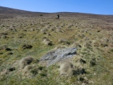
Series of Phrygian Tumuli in Ankara-Bestepeler dating to the Phrygian settlement phase of the city in the 8th-6th centuries BCE. Some were destroyed over the last century due to urban expansion.
GPS position is given for the Ataturk Mausoleum, which sits on one of the more prominent ones. Rescue excavations were carried out around 1940-43.
You may be viewing yesterday's version of this page. To see the most up to date information please register for a free account.
Do not use the above information on other web sites or publications without permission of the contributor.
Nearby Images from Flickr
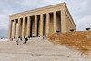


The above images may not be of the site on this page, but were taken nearby. They are loaded from Flickr so please click on them for image credits.
Click here to see more info for this site
Nearby sites
Click here to view sites on an interactive map of the areaKey: Red: member's photo, Blue: 3rd party photo, Yellow: other image, Green: no photo - please go there and take one, Grey: site destroyed
Download sites to:
KML (Google Earth)
GPX (GPS waypoints)
CSV (Garmin/Navman)
CSV (Excel)
To unlock full downloads you need to sign up as a Contributory Member. Otherwise downloads are limited to 50 sites.
Turn off the page maps and other distractions
Nearby sites listing. In the following links * = Image available
2.6km NE 56° Ankara Museum of Anatolian Civilizations* Museum
2.8km NE 41° Ankara Temple of Augustus and Roma* Ancient Temple
5.8km WSW 241° Middle East Technical University Museum Museum
8.7km SSW 209° Kocumbeli Ancient Village or Settlement
49.8km SSW 209° Gavurkale* Ancient Village or Settlement
57.9km WSW 245° Hacitugrul Tumulus Ancient Village or Settlement
63.3km SE 127° Büklükale Ancient Village or Settlement
68.1km WSW 246° Beycegiz Tumulus* Chambered Tomb
77.8km WSW 247° Midas Tumulus* Artificial Mound
77.9km WSW 247° Gordion Museum Museum
79.5km WSW 248° Gordion* Ancient Village or Settlement
101.2km SW 234° Yagri* Ancient Village or Settlement
102.6km SE 127° Kaman Kalehoyuk* Ancient Village or Settlement
104.0km SE 128° Kaman Kalehoyuk Archaeological Museum* Museum
125.7km ESE 122° Yassihöyük Ancient Village or Settlement
126.0km WSW 239° Pessinous* Ancient Temple
126.7km ESE 114° Hashöyük Ancient Village or Settlement
131.4km ENE 70° Boyali Hoyuk Ancient Village or Settlement
133.2km SE 130° Malkaya* Carving
137.3km NW 311° Bithynium Ancient Village or Settlement
142.6km SE 127° Kirsehir Museum Museum
148.1km N 355° Göztepe Tumulus* Artificial Mound
152.0km E 85° Hattuşa* Ancient Village or Settlement
152.5km NNE 18° Kahin Tepe* Ancient Village or Settlement
153.4km E 85° Yazilikaya* Carving
View more nearby sites and additional images


 We would like to know more about this location. Please feel free to add a brief description and any relevant information in your own language.
 Wir möchten mehr über diese Stätte erfahren. Bitte zögern Sie nicht, eine kurze Beschreibung und relevante Informationen in Deutsch hinzuzufügen.
 Nous aimerions en savoir encore un peu sur les lieux. S'il vous plaît n'hesitez pas à ajouter une courte description et tous les renseignements pertinents dans votre propre langue.
 Quisieramos informarnos un poco más de las lugares. No dude en añadir una breve descripción y otros datos relevantes en su propio idioma.