

<< Our Photo Pages >> Yagri - Ancient Village or Settlement in Turkey
Submitted by AlexHunger on Saturday, 13 October 2007 Page Views: 4252
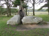
Multi-periodSite Name: Yagri Alternative Name: YağrıCountry: Turkey Type: Ancient Village or Settlement
Nearest Town: Eskisehir Nearest Village: Gunyuzu
Latitude: 39.384003N Longitude: 31.886138E
Condition:
| 5 | Perfect |
| 4 | Almost Perfect |
| 3 | Reasonable but with some damage |
| 2 | Ruined but still recognisable as an ancient site |
| 1 | Pretty much destroyed, possibly visible as crop marks |
| 0 | No data. |
| -1 | Completely destroyed |
| 5 | Superb |
| 4 | Good |
| 3 | Ordinary |
| 2 | Not Good |
| 1 | Awful |
| 0 | No data. |
| 5 | Can be driven to, probably with disabled access |
| 4 | Short walk on a footpath |
| 3 | Requiring a bit more of a walk |
| 2 | A long walk |
| 1 | In the middle of nowhere, a nightmare to find |
| 0 | No data. |
| 5 | co-ordinates taken by GPS or official recorded co-ordinates |
| 4 | co-ordinates scaled from a detailed map |
| 3 | co-ordinates scaled from a bad map |
| 2 | co-ordinates of the nearest village |
| 1 | co-ordinates of the nearest town |
| 0 | no data |
Be the first person to rate this site - see the 'Contribute!' box in the right hand menu.
Internal Links:
External Links:
")
Ancient Hittite Settlement.
Coordinates are for Yağrı Höyük.
You may be viewing yesterday's version of this page. To see the most up to date information please register for a free account.
Do not use the above information on other web sites or publications without permission of the contributor.
Click here to see more info for this site
Nearby sites
Click here to view sites on an interactive map of the areaKey: Red: member's photo, Blue: 3rd party photo, Yellow: other image, Green: no photo - please go there and take one, Grey: site destroyed
Download sites to:
KML (Google Earth)
GPX (GPS waypoints)
CSV (Garmin/Navman)
CSV (Excel)
To unlock full downloads you need to sign up as a Contributory Member. Otherwise downloads are limited to 50 sites.
Turn off the page maps and other distractions
Nearby sites listing. In the following links * = Image available
26.7km WSW 257° Pessinous* Ancient Temple
30.6km NNE 15° Gordion* Ancient Village or Settlement
31.3km NNE 18° Gordion Museum Museum
31.5km NNE 18° Midas Tumulus* Artificial Mound
37.3km NNE 31° Beycegiz Tumulus* Chambered Tomb
46.1km NE 39° Hacitugrul Tumulus Ancient Village or Settlement
60.1km ENE 74° Gavurkale* Ancient Village or Settlement
93.4km NE 55° Kocumbeli Ancient Village or Settlement
95.4km NE 53° Middle East Technical University Museum Museum
99.9km WNW 281° Kulluoba Hoyuk Ancient Village or Settlement
101.2km NE 53° Ankara Tumuli* Round Barrow(s)
101.6km W 260° Pismis Kale Hillfort
102.9km W 260° Areyastis Monument* Sculptured Stone
103.0km W 259° Midas City* Ancient Village or Settlement
103.7km S 176° Yalburt* Carving
103.8km W 261° Gerdek Kaya* Rock Cut Tomb
103.8km NE 53° Ankara Museum of Anatolian Civilizations* Museum
103.9km NE 53° Ankara Temple of Augustus and Roma* Ancient Temple
111.5km W 261° Kümbet North Tomb* Rock Cut Tomb
111.7km W 261° Kümbet Lion Tomb* Rock Cut Tomb
111.7km W 261° Kümbet Rock Sanctuary* Ancient Temple
123.1km WSW 253° Aslantas* Carving
123.2km WSW 253° Yilantas* Rock Cut Tomb
123.8km WSW 253° Maltas* Rock Cut Tomb
129.2km WSW 257° Aslankaya* Carving
View more nearby sites and additional images


 We would like to know more about this location. Please feel free to add a brief description and any relevant information in your own language.
 Wir möchten mehr über diese Stätte erfahren. Bitte zögern Sie nicht, eine kurze Beschreibung und relevante Informationen in Deutsch hinzuzufügen.
 Nous aimerions en savoir encore un peu sur les lieux. S'il vous plaît n'hesitez pas à ajouter une courte description et tous les renseignements pertinents dans votre propre langue.
 Quisieramos informarnos un poco más de las lugares. No dude en añadir una breve descripción y otros datos relevantes en su propio idioma.