<< Our Photo Pages >> Gordion - Ancient Village or Settlement in Turkey

Submitted by davidmorgan on Sunday, 07 December 2014  Page Views: 7475

Multi-periodSite Name: Gordion Alternative Name: Yassihöyük
Country: Turkey
NOTE: This site is 64.78 km away from the location you searched for.

Type: Ancient Village or Settlement
Nearest Town: Ankara  Nearest Village: Polatli
Latitude: 39.649860N  Longitude: 31.977660E
Condition:
5Perfect
4Almost Perfect
3Reasonable but with some damage
2Ruined but still recognisable as an ancient site
1Pretty much destroyed, possibly visible as crop marks
0No data.
-1Completely destroyed
2 Ambience:
5Superb
4Good
3Ordinary
2Not Good
1Awful
0No data.
3 Access:
5Can be driven to, probably with disabled access
4Short walk on a footpath
3Requiring a bit more of a walk
2A long walk
1In the middle of nowhere, a nightmare to find
0No data.
5 Accuracy:
5co-ordinates taken by GPS or official recorded co-ordinates
4co-ordinates scaled from a detailed map
3co-ordinates scaled from a bad map
2co-ordinates of the nearest village
1co-ordinates of the nearest town
0no data
5

Internal Links:
External Links:

Gordion
Gordion submitted by davidmorgan : Sited on the plains of the Anatolian plateau. (Vote or comment on this photo)
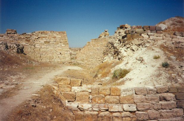
First a Hittite city of the middle bronze age from around 1600 BCE, then the capital of the Phrygian Kingdom dating to the 8th century BCE, now a mound of remains. At confluence of the Sakarya (Sangarios) and Porsuk River. The city boasts a monumental gateway, the remains of a palace and several megarons.

Note: Archaeologists uncover massive fortifications in ancient city of King Midas, see the comment on this page for more
You may be viewing yesterday's version of this page. To see the most up to date information please register for a free account.

Gordion
Gordion submitted by davidmorgan : The main gateway. (Vote or comment on this photo)

Gordion
Gordion submitted by davidmorgan : View across to the burial tumuli from inside the walls of Gordion. (Vote or comment on this photo)

Do not use the above information on other web sites or publications without permission of the contributor.

Nearby Images from Flickr
Midas Tümülüsü
Midas Tümülüsü
Gordion Ancient City
Midas Tümülüsü
Gordion Ancient City

The above images may not be of the site on this page, but were taken nearby. They are loaded from Flickr so please click on them for image credits.


Click here to see more info for this site

Nearby sites

Click here to view sites on an interactive map of the area

Key: Red: member's photo, Blue: 3rd party photo, Yellow: other image, Green: no photo - please go there and take one, Grey: site destroyed

Download sites to:
KML (Google Earth)
GPX (GPS waypoints)
CSV (Garmin/Navman)
CSV (Excel)

To unlock full downloads you need to sign up as a Contributory Member. Otherwise downloads are limited to 50 sites.


Turn off the page maps and other distractions

Nearby sites listing. In the following links * = Image available
 1.7km E 79° Gordion Museum Museum
 1.8km ENE 75° Midas Tumulus* Artificial Mound
 11.7km ENE 78° Beycegiz Tumulus* Chambered Tomb
 21.8km ENE 73° Hacitugrul Tumulus Ancient Village or Settlement
 30.6km SSW 195° Yagri* Ancient Village or Settlement
 49.0km SW 224° Pessinous* Ancient Temple
 51.5km ESE 105° Gavurkale* Ancient Village or Settlement
 72.9km ENE 71° Kocumbeli Ancient Village or Settlement
 73.7km ENE 68° Middle East Technical University Museum Museum
 79.5km ENE 67° Ankara Tumuli* Round Barrow(s)
 82.0km ENE 66° Ankara Temple of Augustus and Roma* Ancient Temple
 82.1km ENE 67° Ankara Museum of Anatolian Civilizations* Museum
 106.2km W 265° Kulluoba Hoyuk Ancient Village or Settlement
 117.9km WSW 246° Pismis Kale Hillfort
 119.0km WSW 247° Areyastis Monument* Sculptured Stone
 119.6km WSW 246° Midas City* Ancient Village or Settlement
 119.6km WSW 247° Gerdek Kaya* Rock Cut Tomb
 124.5km E 93° Büklükale Ancient Village or Settlement
 124.5km NNW 346° Bithynium Ancient Village or Settlement
 127.0km WSW 248° Kümbet North Tomb* Rock Cut Tomb
 127.4km WSW 248° Kümbet Rock Sanctuary* Ancient Temple
 127.4km WSW 248° Kümbet Lion Tomb* Rock Cut Tomb
 132.9km S 180° Yalburt* Carving
 141.8km WSW 242° Aslantas* Carving
 141.8km WSW 242° Yilantas* Rock Cut Tomb
View more nearby sites and additional images

<< Frith Hall

Tareen basin and cup marks >>

Please add your thoughts on this site

Magic Stones: The Secret World of Ancient Megaliths

Magic Stones: The Secret World of Ancient Megaliths

Sponsors

Auto-Translation (Google)

Translate from English into:

"Gordion" | Login/Create an Account | 1 comment
  
Go back to top of page    Comments are owned by the poster. We aren't responsible for their content.
Archaeologists Uncover Massive Fortifications in Ancient City of King Midas by davidmorgan on Sunday, 30 November 2014
(User Info | Send a Message)
A team of archaeologists have unearthed new evidence of massive, monumental defensive works at the Citadel Mound site of ancient Gordion in Turkey. Excavations have also revealed ancient industrial activity dating back to the 11th century BCE.

Located about 70–80 km southwest of Ankara in western Turkey, Gordion, the ancient city best known as the residence of the legendary King Midas, has been the focus of on-and-off excavations since it was discovered in 1893 by Alfred Körte, who initiated exploratory excavations at the site in 1900. Now, Brian Rose of the University of Pennsylvania and colleagues have uncovered massive defensive walls, part of a road, and industrial work spaces dated back to some of the earliest periods of the site. During the early first millennium B.C., Gordion was the power center of the Phrygian kingdom, ruling much of Asia Minor. It was under King Midas and later rulers that the kingdom reached its apogee.

"Gordion’s historical significance derives from its very long and complex sequence of occupation, with seven successive settlements spanning a period of nearly 4500 years," says Rose. "What we discovered was a large glacis or stepped terrace wall over 2.5 m in height, dating to the Early Phrygian period, that supported a substantial fortification wall nearly 3 m. wide. This had proven that the western side of the mound was fortified, and that those fortifications had already been established in the Early Phrygian period (9th c. B.C.), neither of which had been known previously."*

Other massive fortifications, particularly on the eastern side of the Citadel Mound, were uncovered through previous expeditions. But in the last two seasons, beginning in 2013 under Rose's renewed excavations at the south side of the Citadel Mound, solid new evidence has emerged for additional defensive works.

Most significantly, the excavations have also now revealed fortifications spanning the entire time period of Phrygian rule in the region. "We were fortunate this year in uncovering new fortifications dating to three different periods: Early Phrygian (9th c. BC), Middle Phrygian (8th c. BC) and Late Phrygian (6th c. BC).......it is already clear that the scale of the citadel fortifications throughout the entire Phrygian period was much more ambitious than formerly suspected."*

Additionally, Rose's team excavated a sondage trench through what has been designated the Terrace Building, a structure discovered during previous excavations and thought to be a building where industrial activities occurred. They uncovered a large industrial kiln surrounded by ceramic remains that helped to date the feature to the Early Iron Age, or the 11th century BCE. Above and east of the kiln they excavated an Early Iron Age house structure, which contained objects related to textile manufacture, such as spindle whorls and loom weights, and a bell-shaped pit that contained fragments of Early Iron Age handmade wares and animal bones. "The evidence yielded by the sondage demonstrates that there was considerable industrial activity in this area before the Terrace Building was constructed, beginning in the 11th c. B.C.," wrote Rose in a recent newsletter report.*

Concurrent with the excavations and conservation efforts at Gordion, a team under the direction of Stefan Giese and Christian Huebner of GGH in Freiburg, Germany, has been conducting a geophysical survey of the 'Outer Town' using magnetometry and electric resistivity techniques. The Outer Town is a second residential area with detected remains just west of the Lower Town, another residential area that extends below the Citadel Mound. What they found has been no less revelatory than the Citadel Mound discoveries. They detected signs that the Outer Town was "bordered by a ditch with a defensive wall on its interior"*, which the team believes surrounded the entire Outer Town. The findings include other features that suggest a monumental fort. These preliminary finds are similar to those p

Read the rest of this post...
[ Reply to This ]

Your Name: Anonymous [ Register Now ]
Subject:


Add your comment or contribution to this page. Spam or offensive posts are deleted immediately, don't even bother

<<< What is five plus one as a number? (Please type the answer to this question in the little box on the left)
You can also embed videos and other things. For Youtube please copy and paste the 'embed code'.
For Google Street View please include Street View in the text.
Create a web link like this: <a href="https://www.megalithic.co.uk">This is a link</a>  

Allowed HTML is:
<p> <b> <i> <a> <img> <em> <br> <strong> <blockquote> <tt> <li> <ol> <ul> <object> <param> <embed> <iframe>

We would like to know more about this location. Please feel free to add a brief description and any relevant information in your own language.
Wir möchten mehr über diese Stätte erfahren. Bitte zögern Sie nicht, eine kurze Beschreibung und relevante Informationen in Deutsch hinzuzufügen.
Nous aimerions en savoir encore un peu sur les lieux. S'il vous plaît n'hesitez pas à ajouter une courte description et tous les renseignements pertinents dans votre propre langue.
Quisieramos informarnos un poco más de las lugares. No dude en añadir una breve descripción y otros datos relevantes en su propio idioma.