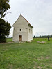
<< Our Photo Pages >> Church of Saint Margaret of Antioch, Kopčany - Misc. Earthwork in Slovakia
Submitted by david-p on Wednesday, 26 February 2020 Page Views: 437
Multi-periodSite Name: Church of Saint Margaret of Antioch, KopčanyCountry: Slovakia
NOTE: This site is 14.224 km away from the location you searched for.
Type: Misc. Earthwork
Nearest Town: holic Nearest Village: Kopčany
Latitude: 48.796200N Longitude: 17.108720E
Condition:
| 5 | Perfect |
| 4 | Almost Perfect |
| 3 | Reasonable but with some damage |
| 2 | Ruined but still recognisable as an ancient site |
| 1 | Pretty much destroyed, possibly visible as crop marks |
| 0 | No data. |
| -1 | Completely destroyed |
| 5 | Superb |
| 4 | Good |
| 3 | Ordinary |
| 2 | Not Good |
| 1 | Awful |
| 0 | No data. |
| 5 | Can be driven to, probably with disabled access |
| 4 | Short walk on a footpath |
| 3 | Requiring a bit more of a walk |
| 2 | A long walk |
| 1 | In the middle of nowhere, a nightmare to find |
| 0 | No data. |
| 5 | co-ordinates taken by GPS or official recorded co-ordinates |
| 4 | co-ordinates scaled from a detailed map |
| 3 | co-ordinates scaled from a bad map |
| 2 | co-ordinates of the nearest village |
| 1 | co-ordinates of the nearest town |
| 0 | no data |
Internal Links:
External Links:
")
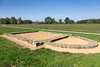
I have visited this site a few times. It is of course of immense religious significance to the people of Slovakia, plus it has ancient runes on the external walls.
However if one looks at the site there is to my opinion remains of an earthen circle with what appears to be almost perfect East-West alignments. There appears evidence of earthen works?
There are shaped stones laid on the grounds that are within the circle that to my mind are ancient stones that have been Christianised and laid flat.
More details at: http://apsida.sk/c/802/kopcany
You may be viewing yesterday's version of this page. To see the most up to date information please register for a free account.
")
Do not use the above information on other web sites or publications without permission of the contributor.
Nearby Images from Flickr

The above images may not be of the site on this page, but were taken nearby. They are loaded from Flickr so please click on them for image credits.
Click here to see more info for this site
Nearby sites
Click here to view sites on an interactive map of the areaKey: Red: member's photo, Blue: 3rd party photo, Yellow: other image, Green: no photo - please go there and take one, Grey: site destroyed
Download sites to:
KML (Google Earth)
GPX (GPS waypoints)
CSV (Garmin/Navman)
CSV (Excel)
To unlock full downloads you need to sign up as a Contributory Member. Otherwise downloads are limited to 50 sites.
Turn off the page maps and other distractions
Nearby sites listing. In the following links * = Image available
1.8km WNW 299° Slavic fortified settlement in Mikulčice* Ancient Village or Settlement
4.1km ENE 70° Menhiry Holic* Standing Stones
20.2km SW 231° Rabensburg Tumulus (2) Round Barrow(s)
22.3km SW 228° Rabensburg Tumuli (1) Round Barrow(s)
31.9km ENE 77° Javorníky Menhir Standing Stone (Menhir)
32.9km WNW 286° Archeopark Pavlov* Museum
33.5km W 279° Klentnice Stone Circle* Modern Stone Circle etc
35.5km WNW 287° Dolní Věstonice* Ancient Village or Settlement
40.5km NNE 32° Archeological Outdoor Museum Modrá* Museum
43.6km NNE 28° The King's Table* Sculptured Stone
46.5km WSW 238° MAMUZ Museum Mistelbach* Museum
46.9km SSW 205° Stillfried Zentrum der Urzeit* Museum
50.8km WSW 243° MAMUZ Schloss Asparn-Zaya* Museum
57.2km NW 321° Moravské zemské muzeum* Museum
57.9km S 182° Stupavsky hrad* Hillfort
59.3km NW 318° Anthropos Pavilion* Museum
63.1km SW 226° Keltenstein Ulrichskirchen* Holed Stone
64.4km NNW 332° Býčí skála* Cave or Rock Shelter
64.8km SW 221° Pillichsdorf Kalvarienberg Tumulus Round Barrow(s)
67.2km S 186° Villa Rustica Bratislava Dubravka Ancient Village or Settlement
69.4km E 80° Roman inscription in Trenčín* Carving
69.5km WSW 239° Niederfellabrunn Leeberg Round Barrow(s)
70.9km WSW 238° Niederhollabrunn Leeberg Round Barrow(s)
73.6km WSW 243° Leeberg* Artificial Mound
75.1km WSW 242° Geitzendorf* Barrow Cemetery
View more nearby sites and additional images


 We would like to know more about this location. Please feel free to add a brief description and any relevant information in your own language.
 Wir möchten mehr über diese Stätte erfahren. Bitte zögern Sie nicht, eine kurze Beschreibung und relevante Informationen in Deutsch hinzuzufügen.
 Nous aimerions en savoir encore un peu sur les lieux. S'il vous plaît n'hesitez pas à ajouter une courte description et tous les renseignements pertinents dans votre propre langue.
 Quisieramos informarnos un poco más de las lugares. No dude en añadir una breve descripción y otros datos relevantes en su propio idioma.