
, Aubrey Burl")
<< Text Pages >> Niederfellabrunn Leeberg - Round Barrow(s) in Austria
Submitted by holubjoh on Friday, 20 October 2017 Page Views: 766
Neolithic and Bronze AgeSite Name: Niederfellabrunn LeebergCountry: Austria Type: Round Barrow(s)
Nearest Village: Niederfellabrunn
Latitude: 48.468010N Longitude: 16.303917E
Condition:
| 5 | Perfect |
| 4 | Almost Perfect |
| 3 | Reasonable but with some damage |
| 2 | Ruined but still recognisable as an ancient site |
| 1 | Pretty much destroyed, possibly visible as crop marks |
| 0 | No data. |
| -1 | Completely destroyed |
| 5 | Superb |
| 4 | Good |
| 3 | Ordinary |
| 2 | Not Good |
| 1 | Awful |
| 0 | No data. |
| 5 | Can be driven to, probably with disabled access |
| 4 | Short walk on a footpath |
| 3 | Requiring a bit more of a walk |
| 2 | A long walk |
| 1 | In the middle of nowhere, a nightmare to find |
| 0 | No data. |
| 5 | co-ordinates taken by GPS or official recorded co-ordinates |
| 4 | co-ordinates scaled from a detailed map |
| 3 | co-ordinates scaled from a bad map |
| 2 | co-ordinates of the nearest village |
| 1 | co-ordinates of the nearest town |
| 0 | no data |
Be the first person to rate this site - see the 'Contribute!' box in the right hand menu.
Internal Links:
External Links:
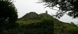
Round barrow in Niederfellabrunn (Austria).
Tumulus
You may be viewing yesterday's version of this page. To see the most up to date information please register for a free account.
Do not use the above information on other web sites or publications without permission of the contributor.
Nearby Images from Flickr


The above images may not be of the site on this page, but were taken nearby. They are loaded from Flickr so please click on them for image credits.
Click here to see more info for this site
Nearby sites
Click here to view sites on an interactive map of the areaKey: Red: member's photo, Blue: 3rd party photo, Yellow: other image, Green: no photo - please go there and take one, Grey: site destroyed
Download sites to:
KML (Google Earth)
GPX (GPS waypoints)
CSV (Garmin/Navman)
CSV (Excel)
To unlock full downloads you need to sign up as a Contributory Member. Otherwise downloads are limited to 50 sites.
Turn off the page maps and other distractions
Nearby sites listing. In the following links * = Image available
1.6km SW 214° Niederhollabrunn Leeberg Round Barrow(s)
6.4km WNW 290° Leeberg* Artificial Mound
7.2km W 279° Geitzendorf* Barrow Cemetery
13.9km SW 227° Hügelgrab Löwenberg* Round Barrow(s)
15.9km ESE 118° Keltenstein Ulrichskirchen* Holed Stone
19.4km NE 46° MAMUZ Schloss Asparn-Zaya* Museum
20.6km SE 127° Pillichsdorf Kalvarienberg Tumulus Round Barrow(s)
23.0km ENE 59° MAMUZ Museum Mistelbach* Museum
25.0km SSE 164° Summstein Wasserpark* Modern Stone Circle etc
29.5km S 172° Naturhistorisches Museum Wien* Museum
40.2km E 99° Stillfried Zentrum der Urzeit* Museum
43.0km NW 311° Kalenderstein von Leodagger* Rock Art
43.5km NW 326° Heiliger Stein (Mitterretzbach)* Rock Art
45.2km WSW 254° Gräberfeld Traisental* Barrow Cemetery
46.7km WSW 254° Urzeitmuseum* Museum
47.6km NNW 336° Stone stele Hradiste* Standing Stone (Menhir)
47.7km ENE 63° Rabensburg Tumuli (1) Round Barrow(s)
47.8km NNW 336° Great Moravia hillfort - Hradiště* Hillfort
48.2km NNW 335° U oveček* Rock Outcrop
48.8km NNW 335° Samaritánka Well* Holy Well or Sacred Spring
49.2km WNW 292° Mold and Rosenburg Ancient Settlements Ancient Village or Settlement
49.2km NNE 32° Klentnice Stone Circle* Modern Stone Circle etc
49.6km ENE 61° Rabensburg Tumulus (2) Round Barrow(s)
49.7km NNW 331° Masovice Prehistoric Settlements Ancient Village or Settlement
52.1km SSW 203° Hafnerberg Steinkreise Stone Circle
View more nearby sites and additional images


 We would like to know more about this location. Please feel free to add a brief description and any relevant information in your own language.
 Wir möchten mehr über diese Stätte erfahren. Bitte zögern Sie nicht, eine kurze Beschreibung und relevante Informationen in Deutsch hinzuzufügen.
 Nous aimerions en savoir encore un peu sur les lieux. S'il vous plaît n'hesitez pas à ajouter une courte description et tous les renseignements pertinents dans votre propre langue.
 Quisieramos informarnos un poco más de las lugares. No dude en añadir una breve descripción y otros datos relevantes en su propio idioma.