<< Our Photo Pages >> Oichi Kofun - Passage Grave in Japan in Honshū
Submitted by aska on Saturday, 12 January 2013 Page Views: 3530
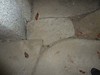
Iron Age and Later PrehistorySite Name: Oichi Kofun Alternative Name: 尾市古墳 尾市1号墳 Oichi IchigōfunCountry: Japan Region: Honshū Type: Passage Grave
Nearest Town: Fukuyama (Hiroshima pref.) Nearest Village: Shin'ishichō-Tsune 新市
Latitude: 34.603100N Longitude: 133.279680E
Condition:
| 5 | Perfect |
| 4 | Almost Perfect |
| 3 | Reasonable but with some damage |
| 2 | Ruined but still recognisable as an ancient site |
| 1 | Pretty much destroyed, possibly visible as crop marks |
| 0 | No data. |
| -1 | Completely destroyed |
| 5 | Superb |
| 4 | Good |
| 3 | Ordinary |
| 2 | Not Good |
| 1 | Awful |
| 0 | No data. |
| 5 | Can be driven to, probably with disabled access |
| 4 | Short walk on a footpath |
| 3 | Requiring a bit more of a walk |
| 2 | A long walk |
| 1 | In the middle of nowhere, a nightmare to find |
| 0 | No data. |
| 5 | co-ordinates taken by GPS or official recorded co-ordinates |
| 4 | co-ordinates scaled from a detailed map |
| 3 | co-ordinates scaled from a bad map |
| 2 | co-ordinates of the nearest village |
| 1 | co-ordinates of the nearest town |
| 0 | no data |
Internal Links:
External Links:
")
You may be viewing yesterday's version of this page. To see the most up to date information please register for a free account.
")
")
")
Do not use the above information on other web sites or publications without permission of the contributor.
Nearby Images from Flickr
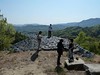

The above images may not be of the site on this page, but were taken nearby. They are loaded from Flickr so please click on them for image credits.
Click here to see more info for this site
Nearby sites
Click here to view sites on an interactive map of the areaKey: Red: member's photo, Blue: 3rd party photo, Yellow: other image, Green: no photo - please go there and take one, Grey: site destroyed
Download sites to:
KML (Google Earth)
GPX (GPS waypoints)
CSV (Garmin/Navman)
CSV (Excel)
To unlock full downloads you need to sign up as a Contributory Member. Otherwise downloads are limited to 50 sites.
Turn off the page maps and other distractions
Nearby sites listing. In the following links * = Image available
16.6km WNW 293° Yano-no Gankai* Natural Stone / Erratic / Other Natural Feature
19.5km WSW 249° Kui-no Gankai* Natural Stone / Erratic / Other Natural Feature
21.5km SSE 162° Jōkoku-ji temple* Modern Stone Circle etc
22.2km SSW 197° Jōdo-ji temple* Modern Stone Circle etc
25.6km SSE 159° Ankoku-ji temple* Modern Stone Circle etc
35.7km SSW 192° Ōjizuka* Chambered Cairn
37.7km NE 55° Kōfuku-ji temple* Modern Stone Circle etc
37.8km NE 55° Raikyū-ji temple* Modern Stone Circle etc
40.2km E 90° Mizue Kofun* Chambered Cairn
41.4km E 97° Hōtō-ji temple* Modern Stone Circle etc
43.2km NE 51° Kubizuka* Round Cairn
44.5km NNE 24° Imami Kofungun* Passage Grave
45.2km E 91° Achi Jinja shrine* Natural Stone / Erratic / Other Natural Feature
45.5km NNE 21° Niimi Bijutsukan museum of art* Modern Stone Circle etc
46.1km E 84° Tanukiiwayama Kofun* Chambered Cairn
46.9km SSW 213° Ōmishima Bijutsukan art gallery* Modern Stone Circle etc
47.1km ENE 73° Kinojō* Hillfort
47.6km NE 52° Yūrin-no-Niwa garden* Modern Stone Circle etc
48.6km E 84° Futago Kofun (in Okayama)* Passage Grave
48.9km NE 40° Ōya Kofungun* Passage Grave
49.0km NE 56° Tennōzan* Not Known (by us)
49.4km ENE 61° Tenrai-an tea room* Modern Stone Circle etc
49.6km NE 40° Sada Kofungun* Passage Grave
50.1km ESE 107° Nozaki Family Residence garden* Modern Stone Circle etc
50.4km E 82° Tatetsuki* Barrow Cemetery
View more nearby sites and additional images


 We would like to know more about this location. Please feel free to add a brief description and any relevant information in your own language.
 Wir möchten mehr über diese Stätte erfahren. Bitte zögern Sie nicht, eine kurze Beschreibung und relevante Informationen in Deutsch hinzuzufügen.
 Nous aimerions en savoir encore un peu sur les lieux. S'il vous plaît n'hesitez pas à ajouter une courte description et tous les renseignements pertinents dans votre propre langue.
 Quisieramos informarnos un poco más de las lugares. No dude en añadir una breve descripción y otros datos relevantes en su propio idioma.