<< Our Photo Pages >> Mabuni Hantabaru - Cave or Rock Shelter in Japan
Submitted by bat400 on Saturday, 17 March 2012 Page Views: 5972
DigsSite Name: Mabuni Hantabaru Alternative Name: 摩文仁ハンタバル遺跡Country: Japan
NOTE: This site is 0.833 km away from the location you searched for.
Type: Cave or Rock Shelter
Nearest Town: Itoman (Okinawa prefecture) Nearest Village: Mabuni 摩文仁
Latitude: 26.090410N Longitude: 127.719010E
Condition:
| 5 | Perfect |
| 4 | Almost Perfect |
| 3 | Reasonable but with some damage |
| 2 | Ruined but still recognisable as an ancient site |
| 1 | Pretty much destroyed, possibly visible as crop marks |
| 0 | No data. |
| -1 | Completely destroyed |
| 5 | Superb |
| 4 | Good |
| 3 | Ordinary |
| 2 | Not Good |
| 1 | Awful |
| 0 | No data. |
| 5 | Can be driven to, probably with disabled access |
| 4 | Short walk on a footpath |
| 3 | Requiring a bit more of a walk |
| 2 | A long walk |
| 1 | In the middle of nowhere, a nightmare to find |
| 0 | No data. |
| 5 | co-ordinates taken by GPS or official recorded co-ordinates |
| 4 | co-ordinates scaled from a detailed map |
| 3 | co-ordinates scaled from a bad map |
| 2 | co-ordinates of the nearest village |
| 1 | co-ordinates of the nearest town |
| 0 | no data |
Internal Links:
External Links:
")
Cemetery dating to the late Jomon period, dating back 3,000-4,000 years.
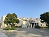
85 sets of bones and burial objects, mainly shells, were excavated in a dig conducted by the Doigahama Site Anthropological Museum. Mabuni is the place where the Battle of Okinawa during the WW2 Pacific War terminated. The Japanese army, chased by landed US army, ran away from capital Naha to this southernmost edge of Okinawa island, many innocent citizen who had lived on their retreating route were scattered by them, ran around the battlefield and were killed or committed suicide here. Still bones of the victims sleeps in the caves around here. In 1972 this area was modified into the peace memorial Quasi-National Park.
Note: Ancient forearm bone from tall man found at archeological site in Okinawa. See comment.
You may be viewing yesterday's version of this page. To see the most up to date information please register for a free account.
")
Do not use the above information on other web sites or publications without permission of the contributor.
Nearby Images from Flickr


The above images may not be of the site on this page, but were taken nearby. They are loaded from Flickr so please click on them for image credits.
Click here to see more info for this site
Nearby sites
Click here to view sites on an interactive map of the areaKey: Red: member's photo, Blue: 3rd party photo, Yellow: other image, Green: no photo - please go there and take one, Grey: site destroyed
Download sites to:
KML (Google Earth)
GPX (GPS waypoints)
CSV (Garmin/Navman)
CSV (Excel)
To unlock full downloads you need to sign up as a Contributory Member. Otherwise downloads are limited to 50 sites.
Turn off the page maps and other distractions
Nearby sites listing. In the following links * = Image available
4.6km WSW 249° Kasakanjā* Natural Stone / Erratic / Other Natural Feature
5.5km WSW 258° Gushikawa-jō (in Itoman city)* Hillfort
6.0km NE 43° Minatogawa fissure* Cave or Rock Shelter
6.4km NNE 26° Sakitari-dō cave* Cave or Rock Shelter
8.1km NNE 33° Itokazu-jō* Hillfort
8.6km NE 46° Tamagusuku-jō* Hillfort
9.7km NNE 28° Tomb of Ufugusuku Aji* Chambered Tomb
10.6km NE 41° Sashiki Yōdore* Chambered Tomb
12.0km NE 41° Futchā-ishi* Standing Stone (Menhir)
12.1km NNW 329° Gushi Hitati* Natural Stone / Erratic / Other Natural Feature
12.1km NE 49° Tomb of Chinen Aji* Rock Cut Tomb
12.1km NE 50° Chinen-jō* Hillfort
13.1km NNW 340° Yamashita-chō cave* Cave or Rock Shelter
13.2km N 8° Tomb of Mabuni branch royal family* Chambered Tomb
13.5km N 358° Tomb of Takushi Uēkata* Chambered Tomb
14.0km N 0° Shuri-jō* Hillfort
14.2km N 358° Tama Udun* Chambered Tomb
14.2km N 1° Banshō-in temple* Modern Stone Circle etc
14.3km N 7° Hitatimō* Natural Stone / Erratic / Other Natural Feature
14.5km NNW 347° Tomb of Tokashiki Sanrā* Chambered Tomb
15.0km N 5° Tomb of Yuntanza branch royal family* Chambered Tomb
15.1km N 3° Tomb of Ie branch royal family* Chambered Tomb
15.6km N 358° Tomb of Ginowan branch royal family* Chambered Tomb
15.8km N 352° Mekaru necropolis* Chambered Tomb
16.2km N 359° Tomb of Urasoe branch royal family* Chambered Tomb
View more nearby sites and additional images


 We would like to know more about this location. Please feel free to add a brief description and any relevant information in your own language.
 Wir möchten mehr über diese Stätte erfahren. Bitte zögern Sie nicht, eine kurze Beschreibung und relevante Informationen in Deutsch hinzuzufügen.
 Nous aimerions en savoir encore un peu sur les lieux. S'il vous plaît n'hesitez pas à ajouter une courte description et tous les renseignements pertinents dans votre propre langue.
 Quisieramos informarnos un poco más de las lugares. No dude en añadir una breve descripción y otros datos relevantes en su propio idioma.