

<< Our Photo Pages >> Gushi Hitati - Natural Stone / Erratic / Other Natural Feature in Japan in Kyūshū
Submitted by Aska on Monday, 01 November 2021 Page Views: 238
Natural PlacesSite Name: Gushi Hitati Alternative Name: 具志火立 Gushi FitatiCountry: Japan Region: Kyūshū Type: Natural Stone / Erratic / Other Natural Feature
Nearest Town: Naha (Okinawa prefecture) Nearest Village: Gushi 具志
Latitude: 26.183760N Longitude: 127.656720E
Condition:
| 5 | Perfect |
| 4 | Almost Perfect |
| 3 | Reasonable but with some damage |
| 2 | Ruined but still recognisable as an ancient site |
| 1 | Pretty much destroyed, possibly visible as crop marks |
| 0 | No data. |
| -1 | Completely destroyed |
| 5 | Superb |
| 4 | Good |
| 3 | Ordinary |
| 2 | Not Good |
| 1 | Awful |
| 0 | No data. |
| 5 | Can be driven to, probably with disabled access |
| 4 | Short walk on a footpath |
| 3 | Requiring a bit more of a walk |
| 2 | A long walk |
| 1 | In the middle of nowhere, a nightmare to find |
| 0 | No data. |
| 5 | co-ordinates taken by GPS or official recorded co-ordinates |
| 4 | co-ordinates scaled from a detailed map |
| 3 | co-ordinates scaled from a bad map |
| 2 | co-ordinates of the nearest village |
| 1 | co-ordinates of the nearest town |
| 0 | no data |
Internal Links:
External Links:
")
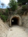
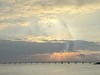
One of the relay stations of beacon-and-watch tower on Okinawa main island which caught the sign of the arrival of tribute or trading ship from surrounding islands and informed to Ryūkyū royal court in Shuri town in Naha city.
After WW II the area was requisitioned by US base then hill was flattened and modified into a residential town. Now only signpost stands on the site.
You may be viewing yesterday's version of this page. To see the most up to date information please register for a free account.
Do not use the above information on other web sites or publications without permission of the contributor.
Nearby Images from Flickr


The above images may not be of the site on this page, but were taken nearby. They are loaded from Flickr so please click on them for image credits.
Click here to see more info for this site
Nearby sites
Click here to view sites on an interactive map of the areaKey: Red: member's photo, Blue: 3rd party photo, Yellow: other image, Green: no photo - please go there and take one, Grey: site destroyed
Download sites to:
KML (Google Earth)
GPX (GPS waypoints)
CSV (Garmin/Navman)
CSV (Excel)
To unlock full downloads you need to sign up as a Contributory Member. Otherwise downloads are limited to 50 sites.
Turn off the page maps and other distractions
Nearby sites listing. In the following links * = Image available
2.5km NE 41° Yamashita-chō cave* Cave or Rock Shelter
4.7km NE 37° Tomb of Tokashiki Sanrā* Chambered Tomb
6.6km ENE 62° Tomb of Takushi Uēkata* Chambered Tomb
6.6km NE 38° Mekaru necropolis* Chambered Tomb
6.9km ENE 56° Tama Udun* Chambered Tomb
7.2km ENE 60° Shuri-jō* Hillfort
7.5km ENE 59° Banshō-in temple* Modern Stone Circle etc
7.6km NE 47° Tomb of Ginowan branch royal family* Chambered Tomb
8.3km NE 45° Tomb of Urasoe branch royal family* Chambered Tomb
8.3km NE 56° Tomb of Ie branch royal family* Chambered Tomb
8.5km ENE 71° Tomb of Mabuni branch royal family* Chambered Tomb
8.8km ENE 58° Tomb of Yuntanza branch royal family* Chambered Tomb
8.8km ENE 64° Hitatimō* Natural Stone / Erratic / Other Natural Feature
9.5km NE 50° Tomb of Tamagusuku Chōkun* Chambered Tomb
10.1km ESE 117° Sakitari-dō cave* Cave or Rock Shelter
10.3km NE 46° Urasoe-jō* Hillfort
10.5km NE 41° Iso-no-Takauhaka* Rock Cut Tomb
10.9km E 99° Tomb of Ufugusuku Aji* Chambered Tomb
11.2km ESE 109° Itokazu-jō* Hillfort
11.5km S 176° Gushikawa-jō (in Itoman city)* Hillfort
11.8km NE 44° Oroku-baka* Rock Cut Tomb
11.9km ESE 120° Minatogawa fissure* Cave or Rock Shelter
12.1km SSE 149° Mabuni Hantabaru* Cave or Rock Shelter
12.2km S 171° Kasakanjā* Natural Stone / Erratic / Other Natural Feature
13.1km ESE 109° Tamagusuku-jō* Hillfort
View more nearby sites and additional images


 We would like to know more about this location. Please feel free to add a brief description and any relevant information in your own language.
 Wir möchten mehr über diese Stätte erfahren. Bitte zögern Sie nicht, eine kurze Beschreibung und relevante Informationen in Deutsch hinzuzufügen.
 Nous aimerions en savoir encore un peu sur les lieux. S'il vous plaît n'hesitez pas à ajouter une courte description et tous les renseignements pertinents dans votre propre langue.
 Quisieramos informarnos un poco más de las lugares. No dude en añadir una breve descripción y otros datos relevantes en su propio idioma.