

<< Our Photo Pages >> Ringval Nimrod - Misc. Earthwork in Czech Republic in Bohemia
Submitted by ladrin on Friday, 14 April 2017 Page Views: 1179
Multi-periodSite Name: Ringval Nimrod Alternative Name: Ringval Pingarten - Včelná, Strážiště - NimrodCountry: Czech Republic
NOTE: This site is 5.604 km away from the location you searched for.
Region: Bohemia Type: Misc. Earthwork
Nearest Town: Mariánské Lázně Nearest Village: Prameny
Latitude: 50.022143N Longitude: 12.714381E
Condition:
| 5 | Perfect |
| 4 | Almost Perfect |
| 3 | Reasonable but with some damage |
| 2 | Ruined but still recognisable as an ancient site |
| 1 | Pretty much destroyed, possibly visible as crop marks |
| 0 | No data. |
| -1 | Completely destroyed |
| 5 | Superb |
| 4 | Good |
| 3 | Ordinary |
| 2 | Not Good |
| 1 | Awful |
| 0 | No data. |
| 5 | Can be driven to, probably with disabled access |
| 4 | Short walk on a footpath |
| 3 | Requiring a bit more of a walk |
| 2 | A long walk |
| 1 | In the middle of nowhere, a nightmare to find |
| 0 | No data. |
| 5 | co-ordinates taken by GPS or official recorded co-ordinates |
| 4 | co-ordinates scaled from a detailed map |
| 3 | co-ordinates scaled from a bad map |
| 2 | co-ordinates of the nearest village |
| 1 | co-ordinates of the nearest town |
| 0 | no data |
Internal Links:
External Links:
")
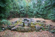
Enigmatic circular earthen construction hidden in the deep woods north from the Mariánské Lázně town (Marienbad) called Nimrod Ringval or simply Strážiště (Fort). Similar structures can be found throughout the western Bohemia region. (For the detailed description about the "ringval" phenomena see the topic "Ringval Mlýnek".)
Being located not far from the famous spa town, Nimrod ringval is a sort of prominent monument. Almost all other similar structures are totally unknown to public. But this site is well signposted and there is a tourist trail.
The structure itself is quite impressive. The inner island has about 12 metres in diametre. Two metres deep moat is still filled with some water even during summer months. Outer earthen rampart has diametre around 40 m. According the expert survey, a wooden building structure used to stay in the middle. An extinct medieval village was documented in the close vicinity.
You may be viewing yesterday's version of this page. To see the most up to date information please register for a free account.
")
")
")
")
")
")
")
Do not use the above information on other web sites or publications without permission of the contributor.
Click here to see more info for this site
Nearby sites
Click here to view sites on an interactive map of the areaKey: Red: member's photo, Blue: 3rd party photo, Yellow: other image, Green: no photo - please go there and take one, Grey: site destroyed
Download sites to:
KML (Google Earth)
GPX (GPS waypoints)
CSV (Garmin/Navman)
CSV (Excel)
To unlock full downloads you need to sign up as a Contributory Member. Otherwise downloads are limited to 50 sites.
Turn off the page maps and other distractions
Nearby sites listing. In the following links * = Image available
5.3km ENE 71° Mnichov 1 propitiatory cross* Ancient Cross
8.1km WSW 255° May Top Kynžvart* Natural Stone / Erratic / Other Natural Feature
10.4km E 101° Ringval Rankovice* Misc. Earthwork
11.2km W 272° Stone Cross Dolní Žandov II* Ancient Cross
11.6km NNW 338° Swedish stone* Standing Stone (Menhir)
11.7km NNE 28° Krásno Propitiatory Cross* Ancient Cross
11.7km W 268° Stone Crosses Dolní Žandov* Ancient Cross
12.4km WNW 297° Ringval Těšov I* Misc. Earthwork
13.1km NNW 330° Stone Cross Rudolec* Ancient Cross
17.6km NW 323° Dasnice propitiatory cross* Ancient Cross
18.5km N 351° Stone crosses Královské Poříčí* Ancient Cross
18.6km NW 319° Svatá Studánka Chlum* Holy Well or Sacred Spring
19.3km NW 321° Stone Cross Chlum* Ancient Cross
19.4km NW 317° Stone Cross Chlum II* Ancient Cross
22.0km NW 314° Ringval Hluboká* Misc. Earthwork
22.2km S 182° Cross stone Lom u Tachova* Sculptured Stone
23.2km W 280° Podhrad stone crosses* Ancient Cross
23.5km S 191° Cross stones Vítkov* Standing Stones
23.9km NW 309° Milhostov 1 propitiatory crosses* Ancient Cross
23.9km WNW 302° Povodí propitiatory cross* Ancient Cross
24.3km SE 130° Stone Cross Konstantinovy Lázně* Ancient Cross
24.3km S 181° Menhir Klíčov* Standing Stone (Menhir)
24.6km NW 308° Milhostov 2 propitiatory crosses* Ancient Cross
25.1km NNW 328° Krajkova Stone Cross* Ancient Cross
25.2km WNW 300° Dvorek propitiatory cross* Ancient Cross
View more nearby sites and additional images


 We would like to know more about this location. Please feel free to add a brief description and any relevant information in your own language.
 Wir möchten mehr über diese Stätte erfahren. Bitte zögern Sie nicht, eine kurze Beschreibung und relevante Informationen in Deutsch hinzuzufügen.
 Nous aimerions en savoir encore un peu sur les lieux. S'il vous plaît n'hesitez pas à ajouter une courte description et tous les renseignements pertinents dans votre propre langue.
 Quisieramos informarnos un poco más de las lugares. No dude en añadir una breve descripción y otros datos relevantes en su propio idioma.