

<< Our Photo Pages >> West Mersea - Artificial Mound in England in Essex
Submitted by Thorgrim on Wednesday, 06 September 2023 Page Views: 17905
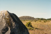
Roman, Greek and ClassicalSite Name: West MerseaCountry: England County: Essex Type: Artificial Mound
Nearest Town: Colchester
Map Ref: TM021149 Landranger Map Number: 168
Latitude: 51.796220N Longitude: 0.929417E
Condition:
| 5 | Perfect |
| 4 | Almost Perfect |
| 3 | Reasonable but with some damage |
| 2 | Ruined but still recognisable as an ancient site |
| 1 | Pretty much destroyed, possibly visible as crop marks |
| 0 | No data. |
| -1 | Completely destroyed |
| 5 | Superb |
| 4 | Good |
| 3 | Ordinary |
| 2 | Not Good |
| 1 | Awful |
| 0 | No data. |
| 5 | Can be driven to, probably with disabled access |
| 4 | Short walk on a footpath |
| 3 | Requiring a bit more of a walk |
| 2 | A long walk |
| 1 | In the middle of nowhere, a nightmare to find |
| 0 | No data. |
| 5 | co-ordinates taken by GPS or official recorded co-ordinates |
| 4 | co-ordinates scaled from a detailed map |
| 3 | co-ordinates scaled from a bad map |
| 2 | co-ordinates of the nearest village |
| 1 | co-ordinates of the nearest town |
| 0 | no data |
Internal Links:
External Links:
I have visited· I would like to visit
indigosue visited on 9th Sep 2023 - their rating: Cond: 4 Access: 4 We went to see this during the heritage open day event and found it very interesting. Afterwards, we went to the Mersea Island Museum to see the lead coffin and glass urn containing the cremated remains of the Roman/Gaulish man who presumably had the burial mound constructed.
")
Directions: Take the B1025 from Colchester, cross the Strood at low tide and the conspicuous mound can be found at TM 021149 on the East Mersea Road almost opposite Dawes Lane.
There is also a rare Roman wheel tomb in a private garden to the east of West Mersea church. It has a circular wall 65ft in diameter with internal walls radiating like spokes from a central chamber.
Note: Mersea Roman Barrow Tours / Talk, Sat/Sun 9/10th September, more in the comments on our page
You may be viewing yesterday's version of this page. To see the most up to date information please register for a free account.
")
")
")
")
")
 (PID:7709)")
 (PID:7708)")
Do not use the above information on other web sites or publications without permission of the contributor.
Click here to see more info for this site
Nearby sites
Key: Red: member's photo, Blue: 3rd party photo, Yellow: other image, Green: no photo - please go there and take one, Grey: site destroyed
Download sites to:
KML (Google Earth)
GPX (GPS waypoints)
CSV (Garmin/Navman)
CSV (Excel)
To unlock full downloads you need to sign up as a Contributory Member. Otherwise downloads are limited to 50 sites.
Turn off the page maps and other distractions
Nearby sites listing. In the following links * = Image available
2.9km SSW 213° St Peter's Well (West Mersea)* Holy Well or Sacred Spring (TM006124)
6.4km W 268° Wigborough Henge* Henge (TL957144)
6.8km NE 40° Alresford Hill Cairn (TM06282022)
6.9km S 174° Othona Roman Fort* Early Christian Sculptured Stone (TM031081)
7.2km W 270° Mill Mound Artificial Mound (TL9487914575)
7.4km NNW 343° Berechurch Dyke Misc. Earthwork
7.4km N 351° Tamworth Mound Misc. Earthwork (TM0065922209)
7.6km NW 315° Gryme's Dyke Ancient Village or Settlement (TL965200)
8.9km NW 323° Heath Farm Dyke Ancient Village or Settlement (TL964218)
9.3km N 3° Annan Road Bronze Age Barrow Cemetery* Barrow Cemetery (TM0215024164)
9.4km NNW 328° Gosbecks Archaeological Park* Ancient Village or Settlement (TL968227)
9.7km E 82° St. Osyth's Well (St. Osyth) Holy Well or Sacred Spring (TM11651670)
9.9km N 2° Greenstead Stones* Natural Stone / Erratic / Other Natural Feature (TM021248)
10.0km NW 322° Stanway Gravel Pit Ancient Village or Settlement (TL956225)
10.1km ENE 76° Flag Inn (St Osyth) Cairn (TM11771777)
10.1km NNW 348° St John's Green (Colchester) Cairn (TL99642468)
10.6km N 350° Colchester Castle Museum* Museum (TL998253)
10.8km NNW 337° Lexden Tumulus* Artificial Mound (TL9753724712)
11.0km NW 304° Birch Long Barrow (TL927207)
11.1km NNW 345° Sheepden Dyke Ancient Village or Settlement (TL987255)
11.2km NE 50° Great Bentley Henge (TM104224)
11.2km NNW 332° Triple Dyke Ancient Village or Settlement (TL965246)
12.8km NNW 343° Lexden Dyke* Ancient Village or Settlement (TL978270)
12.9km WNW 287° Tiptree Moud Round Barrow(s) (TL896182)
14.1km NW 311° Marks Tey Puddingstone* Natural Stone / Erratic / Other Natural Feature (TL911238)
View more nearby sites and additional images


 We would like to know more about this location. Please feel free to add a brief description and any relevant information in your own language.
 Wir möchten mehr über diese Stätte erfahren. Bitte zögern Sie nicht, eine kurze Beschreibung und relevante Informationen in Deutsch hinzuzufügen.
 Nous aimerions en savoir encore un peu sur les lieux. S'il vous plaît n'hesitez pas à ajouter une courte description et tous les renseignements pertinents dans votre propre langue.
 Quisieramos informarnos un poco más de las lugares. No dude en añadir una breve descripción y otros datos relevantes en su propio idioma.