<< Text Pages >> Thetford Barrow - Round Barrow(s) in England in Suffolk
Submitted by coldrum on Sunday, 04 December 2011 Page Views: 3040
Neolithic and Bronze AgeSite Name: Thetford BarrowCountry: England
NOTE: This site is 0.626 km away from the location you searched for.
County: Suffolk Type: Round Barrow(s)
Nearest Town: Thetford
Map Ref: TL86358256
Latitude: 52.409299N Longitude: 0.738287E
Condition:
| 5 | Perfect |
| 4 | Almost Perfect |
| 3 | Reasonable but with some damage |
| 2 | Ruined but still recognisable as an ancient site |
| 1 | Pretty much destroyed, possibly visible as crop marks |
| 0 | No data. |
| -1 | Completely destroyed |
| 5 | Superb |
| 4 | Good |
| 3 | Ordinary |
| 2 | Not Good |
| 1 | Awful |
| 0 | No data. |
| 5 | Can be driven to, probably with disabled access |
| 4 | Short walk on a footpath |
| 3 | Requiring a bit more of a walk |
| 2 | A long walk |
| 1 | In the middle of nowhere, a nightmare to find |
| 0 | No data. |
| 5 | co-ordinates taken by GPS or official recorded co-ordinates |
| 4 | co-ordinates scaled from a detailed map |
| 3 | co-ordinates scaled from a bad map |
| 2 | co-ordinates of the nearest village |
| 1 | co-ordinates of the nearest town |
| 0 | no data |
Internal Links:
External Links:
Round Barrow in Suffolk
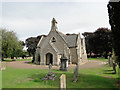
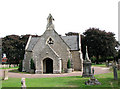
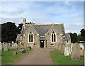
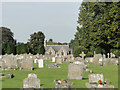
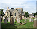
"In 1868 trees were cleared from a tumulus a few yards south of the chapel in the modern cemetery at Thetford, revealing about twelve inhumations oriented with heads to the south. Primary cremations were also noted. Interpreted as a Bronze Age barrow with Saxon secondaries.
The site of the tumulus is within a modern cemetery. The only visible mounding is at TL 86378252, some 50 metres S. of the cemetery chapel. Occupying a local emience, this may possibly mark the barrow site, rather than that of the church. "
Source: Pastscape.
You may be viewing yesterday's version of this page. To see the most up to date information please register for a free account.
Do not use the above information on other web sites or publications without permission of the contributor.
Nearby Images from Geograph Britain and Ireland:
©2014(licence)
©2010(licence)
©2010(licence)
©2016(licence)
©2010(licence)
The above images may not be of the site on this page, they are loaded from Geograph.
Please Submit an Image of this site or go out and take one for us!
Click here to see more info for this site
Nearby sites
Key: Red: member's photo, Blue: 3rd party photo, Yellow: other image, Green: no photo - please go there and take one, Grey: site destroyed
Download sites to:
KML (Google Earth)
GPX (GPS waypoints)
CSV (Garmin/Navman)
CSV (Excel)
To unlock full downloads you need to sign up as a Contributory Member. Otherwise downloads are limited to 50 sites.
Turn off the page maps and other distractions
Nearby sites listing. In the following links * = Image available
793m NE 41° Thetford Puddingstones* Marker Stone (TL8684583181)
1.2km E 80° Thetford Castle* Hillfort (TL875828)
3.0km S 179° Barnham Puddingstone Marker Stone (TL865796)
3.6km S 177° Mill House Barrow Round Barrow(s) (TL867790)
3.6km S 176° Millfield Barn Round Barrow(s) (TL86717898)
3.7km SE 143° Barnham Heath Pit Natural Stone / Erratic / Other Natural Feature (TL887797)
4.2km ESE 108° Seven Hills Barrow Cemetery Barrow Cemetery (TL904814)
5.6km NNW 338° Blood Hill* Round Barrow(s) (TL84078765)
6.3km N 11° Mickle Hill Tumulus* Round Barrow(s) (TL873888)
7.4km NE 44° East Wretham Heath Earthwork* Misc. Earthwork (TL91278814)
8.3km SSE 157° Honington Barrows Round Barrow(s) (TL899751)
8.3km SSW 197° Traveller's Hill* Round Barrow(s) (TL842745)
8.4km ENE 59° Peddars Way* Ancient Trackway (TL9341287119)
8.4km NNW 329° Grimes Puddingstone* Marker Stone (TL8172389589)
8.6km NNW 330° Grime's Graves Flint Mines* Ancient Mine, Quarry or other Industry (TL817898)
8.6km SSE 167° Black Hill-Suffolk* Round Barrow(s) (TL886742)
8.8km WNW 299° Brandon Heritage Museum Museum (TL785865)
8.9km S 182° Seven hills, Rymer Barrow Cemetery (TL863737)
9.1km SSE 161° Troston Mount* Round Barrow(s) (TL896741)
9.4km ESE 106° Knettishall bowl barrow* Round Barrow(s) (TL9546280239)
9.5km WNW 287° White Hill, Suffolk* Round Barrow(s) (TL77168497)
9.5km NW 309° Pepper Hill* Round Barrow(s) (TL787882)
9.6km NW 324° Grimes Graves Barrows* Round Barrow(s) (TL804901)
9.7km E 88° West Harling Heath Barrows Round Barrow(s) (TL96068320)
11.2km SSW 213° West Stow Field Barrow* Round Barrow(s) (TL806729)
View more nearby sites and additional images


 We would like to know more about this location. Please feel free to add a brief description and any relevant information in your own language.
 Wir möchten mehr über diese Stätte erfahren. Bitte zögern Sie nicht, eine kurze Beschreibung und relevante Informationen in Deutsch hinzuzufügen.
 Nous aimerions en savoir encore un peu sur les lieux. S'il vous plaît n'hesitez pas à ajouter une courte description et tous les renseignements pertinents dans votre propre langue.
 Quisieramos informarnos un poco más de las lugares. No dude en añadir una breve descripción y otros datos relevantes en su propio idioma.