<< Our Photo Pages >> Toltec Mounds - Mound A - Artificial Mound in United States in The South
Submitted by bat400 on Saturday, 21 April 2007 Page Views: 7348
Pre-ColumbianSite Name: Toltec Mounds - Mound ACountry: United States
NOTE: This site is 26.12 km away from the location you searched for.
Region: The South Type: Artificial Mound
Nearest Town: Little Rock Nearest Village: Scott
Latitude: 34.646194N Longitude: 92.067194W
Condition:
| 5 | Perfect |
| 4 | Almost Perfect |
| 3 | Reasonable but with some damage |
| 2 | Ruined but still recognisable as an ancient site |
| 1 | Pretty much destroyed, possibly visible as crop marks |
| 0 | No data. |
| -1 | Completely destroyed |
| 5 | Superb |
| 4 | Good |
| 3 | Ordinary |
| 2 | Not Good |
| 1 | Awful |
| 0 | No data. |
| 5 | Can be driven to, probably with disabled access |
| 4 | Short walk on a footpath |
| 3 | Requiring a bit more of a walk |
| 2 | A long walk |
| 1 | In the middle of nowhere, a nightmare to find |
| 0 | No data. |
| 5 | co-ordinates taken by GPS or official recorded co-ordinates |
| 4 | co-ordinates scaled from a detailed map |
| 3 | co-ordinates scaled from a bad map |
| 2 | co-ordinates of the nearest village |
| 1 | co-ordinates of the nearest town |
| 0 | no data |
Internal Links:
External Links:
I have visited· I would like to visit
bat400 has visited here
")
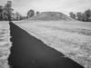
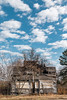
The largest of the Toltec mounds, Mound A has a conical shape and is about 50 feet tall. It is the tallest pre-historic mound in Arkansas. There has been no modern excavation of the mound.
Mound A lies directly on the current back of Mound Pond. In order to avoid damage to the bank by visitors trying to walk around the mound, a boardwalk along the pond edge has been built. Visitors (including those in wheelchairs) can have a waterside view of the mounds and enjoy the birds that frequent Mound Pond.
You may be viewing yesterday's version of this page. To see the most up to date information please register for a free account.
Do not use the above information on other web sites or publications without permission of the contributor.
Nearby Images from Flickr

The above images may not be of the site on this page, but were taken nearby. They are loaded from Flickr so please click on them for image credits.
Click here to see more info for this site
Nearby sites
Click here to view sites on an interactive map of the areaKey: Red: member's photo, Blue: 3rd party photo, Yellow: other image, Green: no photo - please go there and take one, Grey: site destroyed
Download sites to:
KML (Google Earth)
GPX (GPS waypoints)
CSV (Garmin/Navman)
CSV (Excel)
To unlock full downloads you need to sign up as a Contributory Member. Otherwise downloads are limited to 50 sites.
Turn off the page maps and other distractions
Nearby sites listing. In the following links * = Image available
179m SE 130° Toltec Mounds - Mound C* Barrow Cemetery
185m E 90° Toltec Mounds - Mound B* Pyramid / Mastaba
394m ENE 77° Toltec Mounds* Misc. Earthwork
489m ESE 105° Toltec Mounds - Embankment* Misc. Earthwork
94.5km NW 305° Petit Jean State Park* Rock Art
102.5km SE 131° Menard-Hodges Site* Artificial Mound
132.9km ESE 107° Carson Mounds* Artificial Mound
136.8km ESE 116° Alligator Mounds (Clarksdale)* Artificial Mound
139.7km SE 134° Christmas Mound* Artificial Mound
146.4km E 94° West Mounds* Artificial Mound
147.6km E 101° Salomon Mounds* Artificial Mound
149.2km E 99° Barbee Mound* Artificial Mound
151.5km ESE 104° Alcorn Cemetery Mound* Artificial Mound
153.1km E 90° Beaverdam Mounds* Artificial Mound
153.2km E 90° Evansville Mounds* Artificial Mound
153.6km ESE 108° Dunn Mounds* Artificial Mound
154.5km ENE 63° Parkin* Ancient Village or Settlement
154.9km E 82° Commerce Mounds* Artificial Mound
155.7km E 84° Hollywood Mounds* Artificial Mound
155.9km E 86° Johnson Cemetery Mound* Artificial Mound
158.7km SE 144° Winterville* Artificial Mound
162.8km ENE 63° Berry Cemetery Mound* Artificial Mound
163.7km SE 143° Metcalfe Mounds Artificial Mound
163.8km SE 135° Carter Mounds* Artificial Mound
164.9km WSW 247° Ka-Do-Ha* Museum
View more nearby sites and additional images


 We would like to know more about this location. Please feel free to add a brief description and any relevant information in your own language.
 Wir möchten mehr über diese Stätte erfahren. Bitte zögern Sie nicht, eine kurze Beschreibung und relevante Informationen in Deutsch hinzuzufügen.
 Nous aimerions en savoir encore un peu sur les lieux. S'il vous plaît n'hesitez pas à ajouter une courte description et tous les renseignements pertinents dans votre propre langue.
 Quisieramos informarnos un poco más de las lugares. No dude en añadir una breve descripción y otros datos relevantes en su propio idioma.