<< Other Photo Pages >> McLaughlin Mound - Artificial Mound in United States in Great Lakes Midwest
Submitted by stonetracker on Tuesday, 21 February 2023 Page Views: 825
Multi-periodSite Name: McLaughlin Mound Alternative Name: Cemetery MoundCountry: United States
NOTE: This site is 25.858 km away from the location you searched for.
Region: Great Lakes Midwest Type: Artificial Mound
Nearest Town: Mount Vernon OH
Latitude: 40.403680N Longitude: 82.48542W
Condition:
| 5 | Perfect |
| 4 | Almost Perfect |
| 3 | Reasonable but with some damage |
| 2 | Ruined but still recognisable as an ancient site |
| 1 | Pretty much destroyed, possibly visible as crop marks |
| 0 | No data. |
| -1 | Completely destroyed |
| 5 | Superb |
| 4 | Good |
| 3 | Ordinary |
| 2 | Not Good |
| 1 | Awful |
| 0 | No data. |
| 5 | Can be driven to, probably with disabled access |
| 4 | Short walk on a footpath |
| 3 | Requiring a bit more of a walk |
| 2 | A long walk |
| 1 | In the middle of nowhere, a nightmare to find |
| 0 | No data. |
| 5 | co-ordinates taken by GPS or official recorded co-ordinates |
| 4 | co-ordinates scaled from a detailed map |
| 3 | co-ordinates scaled from a bad map |
| 2 | co-ordinates of the nearest village |
| 1 | co-ordinates of the nearest town |
| 0 | no data |
Internal Links:
External Links:
I have visited· I would like to visit
stonetracker would like to visit
")
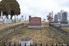
The McLaughlin Mound is located in Mound View Cemetery near the town of Mount Vernon in Knox County, OH.
It currently measures approximately 5.5 feet (1.7 m) high and 75 feet (23 m) in diameter, although it was once at least 10 ft higher. The mound was incorporated as a base for a crypt in a cemetery in the early to mid 1800s, much of its top eventually removed and flattened as the cemetery grew.
In 1845, a partial excavation of the mound at the original ground level revealed a sandstone-lined tomb with a skeleton inside. This is typical of Adena mounds, where a stone or wooden grave is covered with earth. In some cases, additional burials are made later, raising the level of the mound.
When excavated again much later in the 19th century, it was found to contain another skeleton with a shell necklace and copper bracelets, which are common grave goods for an Adena burial. But this skeleton also included a copper breastplate, which would have been a highly unusual item for the Adena. When an iron tomahawk-pipe was also unearthed, this confirmed that the burial was likely intrusive and made after European contact; Adena culture never developed the technology needed to work iron.
The mound is listed on the National Register of Historic Places because of its archaeological significance. Location coordinates are for the top of the mound.
You may be viewing yesterday's version of this page. To see the most up to date information please register for a free account.
")
Do not use the above information on other web sites or publications without permission of the contributor.
Nearby Images from Flickr


The above images may not be of the site on this page, but were taken nearby. They are loaded from Flickr so please click on them for image credits.
Click here to see more info for this site
Nearby sites
Click here to view sites on an interactive map of the areaKey: Red: member's photo, Blue: 3rd party photo, Yellow: other image, Green: no photo - please go there and take one, Grey: site destroyed
Download sites to:
KML (Google Earth)
GPX (GPS waypoints)
CSV (Garmin/Navman)
CSV (Excel)
To unlock full downloads you need to sign up as a Contributory Member. Otherwise downloads are limited to 50 sites.
Turn off the page maps and other distractions
Nearby sites listing. In the following links * = Image available
9.1km NNW 328° Raleigh Mound Artificial Mound
9.4km NNW 335° Braddock Mound Artificial Mound
17.2km S 191° Dixon Mound* Artificial Mound
36.6km S 175° Ferris Owen* Artificial Mound
37.1km S 182° Alligator Mound* Artificial Mound
38.2km S 171° Upham* Artificial Mound
39.1km S 175° Newark Earthworks - Octagon* Misc. Earthwork
39.8km S 172° Newark Earthworks - Wright* Misc. Earthwork
40.6km S 173° Newark Earthworks - Great Circle* Misc. Earthwork
42.3km S 183° Infirmary Mound Artificial Mound
47.6km SSE 166° Tippett Mound Artificial Mound
50.0km SSE 158° Flint Ridge* Ancient Mine, Quarry or other Industry
50.0km S 170° Fairmount* Artificial Mound
53.3km WSW 239° Highbanks Mound I* Artificial Mound
53.9km WSW 238° Highbanks Mound II* Artificial Mound
54.6km WSW 238° Highbanks Park Works* Hillfort
55.8km ESE 110° Porteus Mound* Artificial Mound
58.4km SW 234° Jeffers Mound* Artificial Mound
60.6km SSE 166° Glenford Fort* Hillfort
61.5km SW 224° Ohio Historical Center* Museum
61.8km WSW 239° Wright-Holder Works* Misc. Earthwork
68.3km SW 228° Shrum Mound* Artificial Mound
72.0km SW 217° Indian Mound Park* Artificial Mound
97.0km SSW 195° Tarlton Cross* Artificial Mound
97.4km SSW 204° Circleville* Misc. Earthwork
View more nearby sites and additional images


 We would like to know more about this location. Please feel free to add a brief description and any relevant information in your own language.
 Wir möchten mehr über diese Stätte erfahren. Bitte zögern Sie nicht, eine kurze Beschreibung und relevante Informationen in Deutsch hinzuzufügen.
 Nous aimerions en savoir encore un peu sur les lieux. S'il vous plaît n'hesitez pas à ajouter une courte description et tous les renseignements pertinents dans votre propre langue.
 Quisieramos informarnos un poco más de las lugares. No dude en añadir una breve descripción y otros datos relevantes en su propio idioma.