

<< Text Pages >> Mealhada City Park Sculptured Megalithic Circle - Modern Stone Circle etc in Portugal in Aveiro
Submitted by Aluta on Wednesday, 13 February 2019 Page Views: 744
Modern SitesSite Name: Mealhada City Park Sculptured Megalithic Circle Alternative Name: Conjunto Escultórico MegalíticoCountry: Portugal Distrito: Aveiro Type: Modern Stone Circle etc
Nearest Town: Mealhada Nearest Village: Mealhada
Latitude: 40.382960N Longitude: 8.44803W
Condition:
| 5 | Perfect |
| 4 | Almost Perfect |
| 3 | Reasonable but with some damage |
| 2 | Ruined but still recognisable as an ancient site |
| 1 | Pretty much destroyed, possibly visible as crop marks |
| 0 | No data. |
| -1 | Completely destroyed |
| 5 | Superb |
| 4 | Good |
| 3 | Ordinary |
| 2 | Not Good |
| 1 | Awful |
| 0 | No data. |
| 5 | Can be driven to, probably with disabled access |
| 4 | Short walk on a footpath |
| 3 | Requiring a bit more of a walk |
| 2 | A long walk |
| 1 | In the middle of nowhere, a nightmare to find |
| 0 | No data. |
| 5 | co-ordinates taken by GPS or official recorded co-ordinates |
| 4 | co-ordinates scaled from a detailed map |
| 3 | co-ordinates scaled from a bad map |
| 2 | co-ordinates of the nearest village |
| 1 | co-ordinates of the nearest town |
| 0 | no data |
Internal Links:
External Links:
Modern Stone Circle in Aveiro
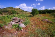
This is a modern, somewhat Stonehenge-like circle of uprights with lintels, with carvings on the uprights and a stone seat in the middle. Portugal is proud of its megalithic heritage and has a number of modern megaliths around the country.
There is a picture of it here on Flickr.
You may be viewing yesterday's version of this page. To see the most up to date information please register for a free account.
Do not use the above information on other web sites or publications without permission of the contributor.
Nearby Images from Flickr


The above images may not be of the site on this page, but were taken nearby. They are loaded from Flickr so please click on them for image credits.
Click here to see more info for this site
Nearby sites
Click here to view sites on an interactive map of the areaKey: Red: member's photo, Blue: 3rd party photo, Yellow: other image, Green: no photo - please go there and take one, Grey: site destroyed
Download sites to:
KML (Google Earth)
GPX (GPS waypoints)
CSV (Garmin/Navman)
CSV (Excel)
To unlock full downloads you need to sign up as a Contributory Member. Otherwise downloads are limited to 50 sites.
Turn off the page maps and other distractions
Nearby sites listing. In the following links * = Image available
26.2km SE 129° Dólmen de São Pedro Dias* Burial Chamber or Dolmen
31.8km S 186° Parque Arqueológico de Conimbriga* Ancient Village or Settlement
31.9km NE 38° Anta da Arca* Burial Chamber or Dolmen
32.9km SW 224° Necrópole do Ferrestelo Cist
33.0km SW 224° Castro de Santa Olaia* Castro or Chafurdão
33.3km NNE 20° Dólmen de Chão Redondo 2* Burial Chamber or Dolmen
33.3km NNE 20° Dólmen de Chão Redondo 1* Burial Chamber or Dolmen
33.4km N 358° Mamoa de Açôres Round Barrow(s)
34.0km NNE 19° Anta do Poço dos Mouros Passage Grave
35.6km NNE 21° Anta da Sepultura do Rei Chambered Tomb
35.9km ENE 58° Castro de Nandunfe Castro or Chafurdão
36.4km NNE 19° Anta da Capela dos Mouros* Burial Chamber or Dolmen
37.4km SW 234° Anta das Carniçosas* Burial Chamber or Dolmen
38.4km S 181° Villa Romana de Rabaçal Ancient Village or Settlement
38.4km ENE 77° Orca do sto. Tisco* Burial Chamber or Dolmen
38.6km ESE 114° Castro da Lomba do Canho Castro or Chafurdão
38.8km NE 42° Dólmen da Lapa da Meruge* Burial Chamber or Dolmen
39.2km N 9° Dólmen do Souto do Coval 2 Burial Chamber or Dolmen
39.3km N 9° Dólmen do Souto do Coval 1 Burial Chamber or Dolmen
39.7km ENE 69° Anta da Arquinha da Moura* Burial Chamber or Dolmen
40.5km NNE 25° Anta Pintada de Antelas* Burial Chamber or Dolmen
40.8km NNE 25° Mamoa 1 da Pedra da Broa* Round Cairn
40.8km NNE 26° Mamoa do Vale do Cando Round Cairn
40.9km NNE 24° Mamoa 2 da Pedra da Broa* Round Cairn
41.2km NNE 26° Mamoa do Paul* Round Cairn
View more nearby sites and additional images


 We would like to know more about this location. Please feel free to add a brief description and any relevant information in your own language.
 Wir möchten mehr über diese Stätte erfahren. Bitte zögern Sie nicht, eine kurze Beschreibung und relevante Informationen in Deutsch hinzuzufügen.
 Nous aimerions en savoir encore un peu sur les lieux. S'il vous plaît n'hesitez pas à ajouter une courte description et tous les renseignements pertinents dans votre propre langue.
 Quisieramos informarnos un poco más de las lugares. No dude en añadir una breve descripción y otros datos relevantes en su propio idioma.