<< Our Photo Pages >> Browne’s Hill - Portal Tomb in Ireland (Republic of) in Co. Carlow
Submitted by jeffrep on Saturday, 24 December 2016 Page Views:
Neolithic and Bronze AgeSite Name: Browne’s Hill Alternative Name: Browne’s Hill Dolmen, Browne's Hill, Brownshill DolmenCountry: Ireland (Republic of)
NOTE: This site is 3.107 km away from the location you searched for.
County: Co. Carlow Type: Portal Tomb
Nearest Town: Carlow
Map Ref: S7538476873
Discovery Map Number: D61
Latitude: 52.837880N Longitude: 6.882105W
Condition:
| 5 | Perfect |
| 4 | Almost Perfect |
| 3 | Reasonable but with some damage |
| 2 | Ruined but still recognisable as an ancient site |
| 1 | Pretty much destroyed, possibly visible as crop marks |
| 0 | No data. |
| -1 | Completely destroyed |
| 5 | Superb |
| 4 | Good |
| 3 | Ordinary |
| 2 | Not Good |
| 1 | Awful |
| 0 | No data. |
| 5 | Can be driven to, probably with disabled access |
| 4 | Short walk on a footpath |
| 3 | Requiring a bit more of a walk |
| 2 | A long walk |
| 1 | In the middle of nowhere, a nightmare to find |
| 0 | No data. |
| 5 | co-ordinates taken by GPS or official recorded co-ordinates |
| 4 | co-ordinates scaled from a detailed map |
| 3 | co-ordinates scaled from a bad map |
| 2 | co-ordinates of the nearest village |
| 1 | co-ordinates of the nearest town |
| 0 | no data |
Internal Links:
External Links:
I have visited· I would like to visit
DrewParsons CharcoalBurner89 would like to visit
bat400 visited on 10th Jul 2019 - their rating: Cond: 3 Amb: 4 Access: 4
macd visited on 1st Mar 2019 - their rating: Cond: 4 Amb: 4 Access: 3 Truly megalithic! It really is a stunning monument, easy to find on the edge of Carlow town, though a little lacking in ambience.
jeffrep visited on 4th May 2009 - their rating: Cond: 3 Amb: 4 Access: 4
Orcinus visited on 1st Jan 1991 University field trip with the late Prof Marek Zvelebil
mark_a AngieLake have visited here
Average ratings for this site from all visit loggers: Condition: 3.33 Ambience: 4 Access: 3.67
")
A fourth upright stands nearby and might possibly be the remains of a forecourt. The extent of the burial-chamber cannot be determined. Text by Anthony Weir.
The Journal of Antiquities includes an entry for the Brownshill Dolmen, County Carlow, Southern Ireland, which includes a photograph, an antiquarian drawing of the dolmen, directions for finding this site, a description, and a list of reference sources for more information.
The County Carlow Tourism website also includes an entry for the Brownshill Dolmen.
Note: The immense Brownshill dolmen on a very chilly winter solstice evening
You may be viewing yesterday's version of this page. To see the most up to date information please register for a free account.
")
")
")
")
")
")
")
")
")
")
")
")
")
")
")
")
")
")
")
")
")
")
")
")
These are just the first 25 photos of Browne’s Hill. If you log in with a free user account you will be able to see our entire collection.
Do not use the above information on other web sites or publications without permission of the contributor.
Click here to see more info for this site
Nearby sites
Click here to view sites on an interactive map of the areaKey: Red: member's photo, Blue: 3rd party photo, Yellow: other image, Green: no photo - please go there and take one, Grey: site destroyed
Download sites to:
KML (Google Earth)
GPX (GPS waypoints)
CSV (Garmin/Navman)
CSV (Excel)
To unlock full downloads you need to sign up as a Contributory Member. Otherwise downloads are limited to 50 sites.
Turn off the page maps and other distractions
Nearby sites listing. In the following links * = Image available
8.7km NNE 21° Castledermot High Crosses* Ancient Cross
10.3km ESE 123° Ardristan* Standing Stone (Menhir) (S8413871337)
14.7km E 87° Haroldstown* Portal Tomb (S90087793)
15.1km ESE 106° Rathgall Destroyed Stone Circle Stone Circle (S900730)
15.2km ESE 105° Rathgall Hill Fort* Hillfort (S90227315)
16.2km NNE 13° Moone High Cross* Ancient Cross (S7891192693)
18.0km NE 48° Baltinglass* Passage Grave (S8855289249)
19.4km WNW 288° Slatt Lower Stone Circle (S568827)
20.4km WNW 300° Druids Altar (Monamanry) Ring Cairn
20.6km NE 54° Gates Of Heaven Burial Chamber or Dolmen
20.8km NW 314° Druids Altar (Co. Laois) Stone Circle (S600910)
21.1km E 93° Clonmore* Ancient Cross
21.9km ENE 57° Boleycarrigeen* Stone Circle
22.8km NW 317° The Ass's Manger* Cist (S5967393415)
23.7km NE 44° Castleruddery* Stone Circle (S9159394210)
23.9km NE 46° Castleruddery Stone Row / Alignment (S925937)
25.6km NNE 19° Brewel Hill Stone Circle (N833013)
25.8km NNE 28° Tournant Stone Circle (N870000)
27.7km NNE 16° Kilgowan* Standing Stone (Menhir)
29.0km NE 53° The Long Stone (Knickeen)* Standing Stone (Menhir) (S983948)
30.9km NW 315° Rock of Dunamase Hillfort (S530982)
31.1km NNE 15° Old Kilcullen High Cross Ancient Cross
31.6km NNE 13° Knockaulin Timber Circle (N820078)
31.6km NE 35° Athgreany* Stone Circle (N930032)
33.3km NW 317° The Heath (Laois)* Barrow Cemetery
View more nearby sites and additional images


 We would like to know more about this location. Please feel free to add a brief description and any relevant information in your own language.
 Wir möchten mehr über diese Stätte erfahren. Bitte zögern Sie nicht, eine kurze Beschreibung und relevante Informationen in Deutsch hinzuzufügen.
 Nous aimerions en savoir encore un peu sur les lieux. S'il vous plaît n'hesitez pas à ajouter une courte description et tous les renseignements pertinents dans votre propre langue.
 Quisieramos informarnos un poco más de las lugares. No dude en añadir una breve descripción y otros datos relevantes en su propio idioma.
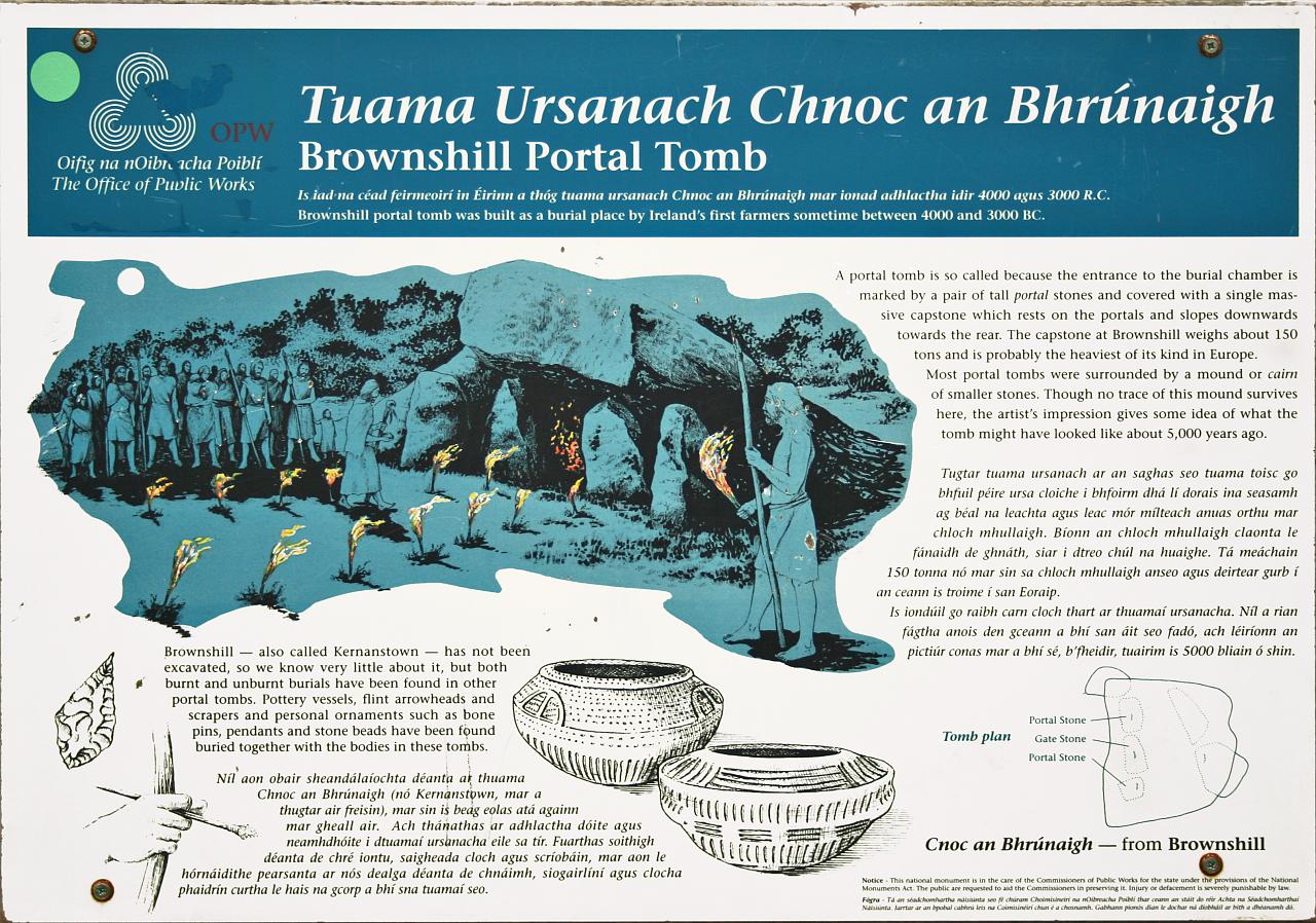