<< Other Photo Pages >> Down County Museum - Museum in Ireland (Northern) in Co. Down
Submitted by vicky on Saturday, 30 November 2002 Page Views: 3673
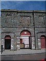
MuseumsSite Name: Down County MuseumCountry: Ireland (Northern)
NOTE: This site is 0.122 km away from the location you searched for.
County: Co. Down Type: Museum
Nearest Town: Downpatrick
Latitude: 54.328497N Longitude: 5.719598W
Condition:
| 5 | Perfect |
| 4 | Almost Perfect |
| 3 | Reasonable but with some damage |
| 2 | Ruined but still recognisable as an ancient site |
| 1 | Pretty much destroyed, possibly visible as crop marks |
| 0 | No data. |
| -1 | Completely destroyed |
| 5 | Superb |
| 4 | Good |
| 3 | Ordinary |
| 2 | Not Good |
| 1 | Awful |
| 0 | No data. |
| 5 | Can be driven to, probably with disabled access |
| 4 | Short walk on a footpath |
| 3 | Requiring a bit more of a walk |
| 2 | A long walk |
| 1 | In the middle of nowhere, a nightmare to find |
| 0 | No data. |
| 5 | co-ordinates taken by GPS or official recorded co-ordinates |
| 4 | co-ordinates scaled from a detailed map |
| 3 | co-ordinates scaled from a bad map |
| 2 | co-ordinates of the nearest village |
| 1 | co-ordinates of the nearest town |
| 0 | no data |
Internal Links:
External Links:
Museum in Co. Down
Collection of local prehistoric items
Address: The Mall, English Street, BT30 6AH
Phone: 01396 615218
Opening Hours: Tuesday - Friday 10.00am - 5.00pm, Saturday and Sunday 12.00pm - 5.00pm
Admission: Free
Visit their web site
You may be viewing yesterday's version of this page. To see the most up to date information please register for a free account.
Do not use the above information on other web sites or publications without permission of the contributor.
davidmorgan has found this location on Google Street View:
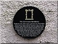
Nearby Images from Geograph Britain and Ireland:
©2014(licence)

©2012(licence)
©2012(licence)
©2014(licence)
©2011(licence)
The above images may not be of the site on this page, they are loaded from Geograph.
Please Submit an Image of this site or go out and take one for us!
Click here to see more info for this site
Nearby sites
Click here to view sites on an interactive map of the areaKey: Red: member's photo, Blue: 3rd party photo, Yellow: other image, Green: no photo - please go there and take one, Grey: site destroyed
Download sites to:
KML (Google Earth)
GPX (GPS waypoints)
CSV (Garmin/Navman)
CSV (Excel)
To unlock full downloads you need to sign up as a Contributory Member. Otherwise downloads are limited to 50 sites.
Turn off the page maps and other distractions
Nearby sites listing. In the following links * = Image available
85m E 83° Mound of Down* Misc. Earthwork
4.2km S 186° Ballynoe* Stone Circle (J4812740378)
4.4km E 83° Slievenagriddle* Burial Chamber or Dolmen (J528453)
4.7km E 89° Ballyalton Court Tomb* Court Tomb
5.7km WNW 285° Annadorn Dolmen (Loughinisland)* Chambered Tomb (NW52870072)
5.8km ENE 74° Loughmoney* Portal Tomb (NW63890021)
6.2km ENE 75° Carrownacaw Long Stone* Standing Stone (Menhir)
7.2km ENE 72° Castle Mahon* Stone Circle (J552470)
9.6km NE 56° Audleystown Court Tomb* Court Tomb (J562503)
10.0km ENE 60° Castleward Standing Stones (J569499)
13.6km SW 223° Wateresk Dolmen* Portal Tomb (J3936234386)
13.8km SW 223° Ballyloughin Standing Stones (J392342)
13.9km SW 224° Wateresk Stone* Standing Stone (Menhir)
15.2km ENE 73° Millin Bay* Burial Chamber or Dolmen (J628495)
16.1km ENE 63° Ballyrusley* Stone Row / Alignment (J6262052280)
17.7km SW 222° Newcastle Stone Circle Stone Circle (J370310)
18.0km W 266° Legananny Cross Stone* Ancient Cross (J304428)
18.4km N 9° Ballymartin Rock Art Rock Art (J50766285)
19.5km W 268° Legananny* Portal Tomb (J2886743397)
20.2km WSW 240° Drumena* Stone Fort or Dun (J3111034018)
21.0km SW 234° King's Grave in Tollymore Forest* Cairn (J318317)
21.0km SW 218° Slieve Donard* Passage Grave (J3580427689)
22.6km N 359° Ballygraffan Portal Tomb* Portal Tomb
23.4km W 260° Moneyslane* Standing Stones
24.9km NE 42° Ballyhalbert Motte* Standing Stones (J6467563509)
View more nearby sites and additional images


 We would like to know more about this location. Please feel free to add a brief description and any relevant information in your own language.
 Wir möchten mehr über diese Stätte erfahren. Bitte zögern Sie nicht, eine kurze Beschreibung und relevante Informationen in Deutsch hinzuzufügen.
 Nous aimerions en savoir encore un peu sur les lieux. S'il vous plaît n'hesitez pas à ajouter une courte description et tous les renseignements pertinents dans votre propre langue.
 Quisieramos informarnos un poco más de las lugares. No dude en añadir una breve descripción y otros datos relevantes en su propio idioma.