 with our Megalithic Portal iPhone app")


<< Our Photo Pages >> Slievenagriddle - Burial Chamber or Dolmen in Ireland (Northern) in Co. Down
Submitted by Anthony_Weir on Monday, 14 October 2002 Page Views: 12203
Neolithic and Bronze AgeSite Name: Slievenagriddle Alternative Name: The Giant’s GriddleCountry: Ireland (Northern) County: Co. Down Type: Burial Chamber or Dolmen
Nearest Town: Downpatrick
Map Ref: J528453
Discoverer Map Number: D21
Latitude: 54.333538N Longitude: 5.651673W
Condition:
| 5 | Perfect |
| 4 | Almost Perfect |
| 3 | Reasonable but with some damage |
| 2 | Ruined but still recognisable as an ancient site |
| 1 | Pretty much destroyed, possibly visible as crop marks |
| 0 | No data. |
| -1 | Completely destroyed |
| 5 | Superb |
| 4 | Good |
| 3 | Ordinary |
| 2 | Not Good |
| 1 | Awful |
| 0 | No data. |
| 5 | Can be driven to, probably with disabled access |
| 4 | Short walk on a footpath |
| 3 | Requiring a bit more of a walk |
| 2 | A long walk |
| 1 | In the middle of nowhere, a nightmare to find |
| 0 | No data. |
| 5 | co-ordinates taken by GPS or official recorded co-ordinates |
| 4 | co-ordinates scaled from a detailed map |
| 3 | co-ordinates scaled from a bad map |
| 2 | co-ordinates of the nearest village |
| 1 | co-ordinates of the nearest town |
| 0 | no data |
Internal Links:
External Links:
I have visited· I would like to visit
DrewParsons SolarMegalith would like to visit
")
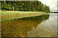
Close by at the base of Slievenagriddle is Ballyalton court-tomb, buried in a dense thorn thicket and rarely accessible. Also not far away is Loughmoney "dolmen" a remnant of a court-tomb (see picture left).
~ 1.6 km NE in Carrownacaw is “The Long Stone” a tall thin standing-stone of schist, 3.3 metres tall - and the only Irish menhir to be supported by a hawser wrapped around a tree. This is reached by a road which passes picturesque Loughmoney Dolmen: just two sidestones and a roofstone of a vanished court-tomb in a field.
~ 6.4 km NE in Audleystown, close to Strangford Lough, is a well-preserved double-court tomb built of low stones and comprising shallow forecourts, two galleries of four chambers each, a cairn some 27 metres long, and a kerb made not of orthostats, but dry-stone walling.
~ 4.4 km ENE, in the front garden of No. 109 Ballyculter Road in Churchtown, 40 metres from the road-junction at Ballyculter, is part of a natural rock-outcrop decorated with two worn sets of concentric circles – best seen when wet. One of the sets has a remarkable 10 rings, while the other has 6. These are more in the style of passage-tomb art than the usual Bronze Age rock-scribings or petroglyphs.
You may be viewing yesterday's version of this page. To see the most up to date information please register for a free account.
")
Do not use the above information on other web sites or publications without permission of the contributor.
Nearby Images from Geograph Britain and Ireland:
©2010(licence)
©2015(licence)
©2011(licence)
©2011(licence)
©2008(licence)
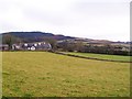
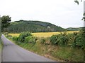
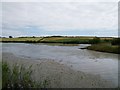
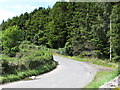
The above images may not be of the site on this page, they are loaded from Geograph.
Please Submit an Image of this site or go out and take one for us!
Click here to see more info for this site
Nearby sites
Click here to view sites on an interactive map of the areaKey: Red: member's photo, Blue: 3rd party photo, Yellow: other image, Green: no photo - please go there and take one, Grey: site destroyed
Download sites to:
KML (Google Earth)
GPX (GPS waypoints)
CSV (Garmin/Navman)
CSV (Excel)
To unlock full downloads you need to sign up as a Contributory Member. Otherwise downloads are limited to 50 sites.
Turn off the page maps and other distractions
Nearby sites listing. In the following links * = Image available
1.5km NE 48° Loughmoney* Portal Tomb (NW63890021)
1.9km ENE 57° Carrownacaw Long Stone* Standing Stone (Menhir)
2.9km ENE 57° Castle Mahon* Stone Circle (J552470)
4.4km W 263° Mound of Down* Misc. Earthwork
4.4km W 263° Down County Museum* Museum
6.0km NE 36° Audleystown Court Tomb* Court Tomb (J562503)
6.1km NE 44° Castleward Standing Stones (J569499)
6.8km SW 225° Ballynoe* Stone Circle (J4812740378)
9.9km W 276° Annadorn Dolmen (Loughinisland)* Chambered Tomb (NW52870072)
10.8km ENE 69° Millin Bay* Burial Chamber or Dolmen (J628495)
12.0km ENE 56° Ballyrusley* Stone Row / Alignment (J6262052280)
17.3km SW 233° Wateresk Dolmen* Portal Tomb (J3936234386)
17.5km SW 233° Ballyloughin Standing Stones (J392342)
17.6km SW 233° Wateresk Stone* Standing Stone (Menhir)
17.6km N 355° Ballymartin Rock Art Rock Art (J50766285)
21.3km SW 230° Newcastle Stone Circle Stone Circle (J370310)
21.7km NE 35° Ballyhalbert Motte* Standing Stones (J6467563509)
22.4km NNE 32° Ballyhemlin* Standing Stone (Menhir) (J6407064750)
22.5km W 266° Legananny Cross Stone* Ancient Cross (J304428)
22.5km NNW 348° Ballygraffan Portal Tomb* Portal Tomb
23.9km W 267° Legananny* Portal Tomb (J2886743397)
24.3km N 10° Mount Stewart Cist* Cist (J5624069380)
24.4km WSW 244° Drumena* Stone Fort or Dun (J3111034018)
24.4km SW 226° Slieve Donard* Passage Grave (J3580427689)
24.9km WSW 239° King's Grave in Tollymore Forest* Cairn (J318317)
View more nearby sites and additional images


 We would like to know more about this location. Please feel free to add a brief description and any relevant information in your own language.
 Wir möchten mehr über diese Stätte erfahren. Bitte zögern Sie nicht, eine kurze Beschreibung und relevante Informationen in Deutsch hinzuzufügen.
 Nous aimerions en savoir encore un peu sur les lieux. S'il vous plaît n'hesitez pas à ajouter une courte description et tous les renseignements pertinents dans votre propre langue.
 Quisieramos informarnos un poco más de las lugares. No dude en añadir una breve descripción y otros datos relevantes en su propio idioma.