<< Our Photo Pages >> St Columba's Well (Southend) - Holy Well or Sacred Spring in Scotland in Argyll
Submitted by KiwiBetsy on Tuesday, 10 October 2006 Page Views: 6399
Springs and Holy WellsSite Name: St Columba's Well (Southend)Country: Scotland
NOTE: This site is 1.612 km away from the location you searched for.
County: Argyll Type: Holy Well or Sacred Spring
Nearest Town: Campbeltown Nearest Village: Southend
Map Ref: NR673077
Latitude: 55.308206N Longitude: 5.6682W
Condition:
| 5 | Perfect |
| 4 | Almost Perfect |
| 3 | Reasonable but with some damage |
| 2 | Ruined but still recognisable as an ancient site |
| 1 | Pretty much destroyed, possibly visible as crop marks |
| 0 | No data. |
| -1 | Completely destroyed |
| 5 | Superb |
| 4 | Good |
| 3 | Ordinary |
| 2 | Not Good |
| 1 | Awful |
| 0 | No data. |
| 5 | Can be driven to, probably with disabled access |
| 4 | Short walk on a footpath |
| 3 | Requiring a bit more of a walk |
| 2 | A long walk |
| 1 | In the middle of nowhere, a nightmare to find |
| 0 | No data. |
| 5 | co-ordinates taken by GPS or official recorded co-ordinates |
| 4 | co-ordinates scaled from a detailed map |
| 3 | co-ordinates scaled from a bad map |
| 2 | co-ordinates of the nearest village |
| 1 | co-ordinates of the nearest town |
| 0 | no data |
Internal Links:
External Links:
I have visited· I would like to visit
MonteZuma would like to visit
FrothNinja has visited here
 (PID:24858)")
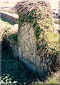
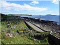
This well is kept company by an old cemetery, a ruined 13th century church and a 'footprint' left by St Columba when he came ashore on a nearby beach in the 6th century to convert the Picts to Christianity. There is actually no evidence that St Columba was ever here but there is evidence of an earlier church or chapel on the site.
You may be viewing yesterday's version of this page. To see the most up to date information please register for a free account.
 (PID:236568)")
 (PID:236570)")
 (PID:236569)")
 (PID:24859)")
Do not use the above information on other web sites or publications without permission of the contributor.
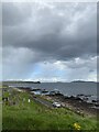
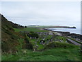
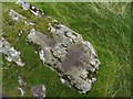
Nearby Images from Geograph Britain and Ireland:
©2007(licence)
©2024(licence)
©2009(licence)
©2012(licence)
©2012(licence)
The above images may not be of the site on this page, they are loaded from Geograph.
Please Submit an Image of this site or go out and take one for us!
Click here to see more info for this site
Nearby sites
Key: Red: member's photo, Blue: 3rd party photo, Yellow: other image, Green: no photo - please go there and take one, Grey: site destroyed
Download sites to:
KML (Google Earth)
GPX (GPS waypoints)
CSV (Garmin/Navman)
CSV (Excel)
To unlock full downloads you need to sign up as a Contributory Member. Otherwise downloads are limited to 50 sites.
Turn off the page maps and other distractions
Nearby sites listing. In the following links * = Image available
2.5km E 83° Brunerican Standing Stone Standing Stone (Menhir) (NR6976207877)
5.0km ENE 68° Blasthill* Chambered Cairn (NR7201009289)
5.6km NNE 29° Knockstapple* Standing Stone (Menhir) (NR70261241)
6.5km ENE 73° Macharioch Chambered Cairn (NR73640927)
7.6km N 349° Lochorodale Chambered Cairn* Chambered Cairn (NR66231522)
7.8km N 352° Lochorodale Stone Standing Stone (Menhir) (NR66571546)
8.7km NNW 347° Lochorodale Cairn (NR658163)
9.9km ENE 60° Dun Bastard (Campbelltown) Hillfort (NR76121220)
12.4km N 9° Culinlongart Recumbent Standing Stone (Menhir) (NR69951982)
12.4km N 9° Stewarton Recumbent Stone Standing Stone (Menhir) (NR6995719821)
13.0km NNE 31° Glenramskill Fort* Hillfort (NR7455118507)
13.2km NNW 344° Macrihanish Stone Row / Alignment (NR644206)
13.5km NNE 18° Campbeltown Museum* Museum (NR7211620336)
14.4km NNE 18° Campbeltown* Standing Stone (Menhir) (NR7239321234)
15.9km N 4° Craigs East (Kintyre)* Standing Stone (Menhir) (NR6932623544)
16.0km N 3° Craigs (Kintyre)* Standing Stone (Menhir) (NR6903123633)
16.5km N 5° Craigs NE (Kintyre) Recumbent Standing Stone (Menhir) (NR6949924121)
16.8km N 352° Clochkeil* Stone Row / Alignment (NR6577824456)
17.8km NNE 20° Greenland Chambered Cairn (NR743241)
18.1km N 4° High Park Stone* Standing Stone (Menhir) (NR69442573)
19.6km N 8° Skeroblin Stone* Standing Stone (Menhir) (NR70932701)
19.8km NNE 23° Glenlussa Lodge* Standing Stone (Menhir) (NR76152543)
19.8km N 7° Skeroblin Row Stone Row / Alignment (NR706273)
19.9km N 354° Tangy Glen Recumbent Standing Stone (Menhir) (NR6610827557)
19.9km NNE 20° Kilkeddan Farm cist burial Cist (NR75252600)
View more nearby sites and additional images


 We would like to know more about this location. Please feel free to add a brief description and any relevant information in your own language.
 Wir möchten mehr über diese Stätte erfahren. Bitte zögern Sie nicht, eine kurze Beschreibung und relevante Informationen in Deutsch hinzuzufügen.
 Nous aimerions en savoir encore un peu sur les lieux. S'il vous plaît n'hesitez pas à ajouter une courte description et tous les renseignements pertinents dans votre propre langue.
 Quisieramos informarnos un poco más de las lugares. No dude en añadir una breve descripción y otros datos relevantes en su propio idioma.