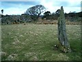
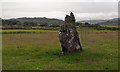
<< Our Photo Pages >> Ardpatrick - Standing Stone (Menhir) in Scotland in Argyll
Submitted by Andy B on Sunday, 11 February 2001 Page Views: 9367
Neolithic and Bronze AgeSite Name: ArdpatrickCountry: Scotland
NOTE: This site is 1.386 km away from the location you searched for.
County: Argyll Type: Standing Stone (Menhir)
Nearest Town: Tarbert Nearest Village: Kilberry
Map Ref: NR757601 Landranger Map Number: 62
Latitude: 55.782029N Longitude: 5.578622W
Condition:
| 5 | Perfect |
| 4 | Almost Perfect |
| 3 | Reasonable but with some damage |
| 2 | Ruined but still recognisable as an ancient site |
| 1 | Pretty much destroyed, possibly visible as crop marks |
| 0 | No data. |
| -1 | Completely destroyed |
| 5 | Superb |
| 4 | Good |
| 3 | Ordinary |
| 2 | Not Good |
| 1 | Awful |
| 0 | No data. |
| 5 | Can be driven to, probably with disabled access |
| 4 | Short walk on a footpath |
| 3 | Requiring a bit more of a walk |
| 2 | A long walk |
| 1 | In the middle of nowhere, a nightmare to find |
| 0 | No data. |
| 5 | co-ordinates taken by GPS or official recorded co-ordinates |
| 4 | co-ordinates scaled from a detailed map |
| 3 | co-ordinates scaled from a bad map |
| 2 | co-ordinates of the nearest village |
| 1 | co-ordinates of the nearest town |
| 0 | no data |
Internal Links:
External Links:
I have visited· I would like to visit
Andy B has visited here
")
County: Knapdale
You may be viewing yesterday's version of this page. To see the most up to date information please register for a free account.
")
")
")
")
Do not use the above information on other web sites or publications without permission of the contributor.
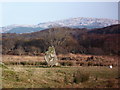
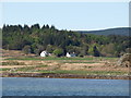
Nearby Images from Geograph Britain and Ireland:
©2006(licence)
©2013(licence)
©2016(licence)

©2016(licence)
©2010(licence)
The above images may not be of the site on this page, they are loaded from Geograph.
Please Submit an Image of this site or go out and take one for us!
Click here to see more info for this site
Nearby sites
Key: Red: member's photo, Blue: 3rd party photo, Yellow: other image, Green: no photo - please go there and take one, Grey: site destroyed
Download sites to:
KML (Google Earth)
GPX (GPS waypoints)
CSV (Garmin/Navman)
CSV (Excel)
To unlock full downloads you need to sign up as a Contributory Member. Otherwise downloads are limited to 50 sites.
![]()
![]()
Turn off the page maps and other distractions
Nearby sites listing. In the following links * = Image available
1.9km NE 48° Tobar Cill'An Aonghais* Holy Well or Sacred Spring (NR772613)
2.1km NW 314° Carse Standing Stones East* Standing Stones (NR7424661640)
2.2km NW 312° Carse Standing Stones West* Standing Stone (Menhir) (NR74146166)
4.0km SSE 168° Dun Skeig* Hillfort (NR76315612)
5.8km SSE 153° Loch Ciaran* Standing Stone (Menhir) (NR78035479)
6.4km NW 308° Kilberry* Sculptured Stone (NR709643)
6.4km SSW 194° Correchrevie Cairn* Cairn (NR738540)
8.1km SSW 196° Ballochroy* Stone Row / Alignment (NR7309352426)
8.4km NW 321° Cretshengan* Standing Stone (Menhir) (NR70726689)
9.2km NNW 327° Dun Cragach Stone Fort or Dun (NR71086805)
11.0km NE 45° Avinagillan* Standing Stone (Menhir) (NR8390367461)
11.0km E 96° Glenreasdale* Chambered Cairn (NR866583)
11.1km NE 50° Escart* Stone Row / Alignment (NR8464266794)
11.3km SW 235° Cnoc nan Gobhar Stone* Standing Stone (Menhir) (NR6607454042)
12.1km SW 232° Kinerarach (Gigha)* Standing Stone (Menhir) (NR6568453210)
12.7km SW 230° Old Wife's Grave, The (Gigha, Isle of) Cairn (NR655524)
12.8km SW 229° Tarbert (Gigha)* Standing Stone (Menhir) (NR6554952292)
14.2km E 98° Skipness Rock Art (NR8967357519)
14.3km NE 54° Mealdarroch Stone Row / Alignment (NR877680)
15.2km SW 223° Druimyeonbeg (Isle of Gigha) Cairn (NR64634958)
15.5km SW 221° Ardminish Cist (NR64954890)
16.0km NNW 337° Kilmory Knap* Sculptured Stone (NR703752)
16.3km SW 221° Cnoc na Croise (Gigha) Cairn (NR64394828)
16.5km SW 221° Cnoc na Carraigh Ogham Stone* Sculptured Stone (NR6426548173)
16.6km N 355° St Columba's Cave* Cave or Rock Shelter (NR751767)
View more nearby sites and additional images


 We would like to know more about this location. Please feel free to add a brief description and any relevant information in your own language.
 Wir möchten mehr über diese Stätte erfahren. Bitte zögern Sie nicht, eine kurze Beschreibung und relevante Informationen in Deutsch hinzuzufügen.
 Nous aimerions en savoir encore un peu sur les lieux. S'il vous plaît n'hesitez pas à ajouter une courte description et tous les renseignements pertinents dans votre propre langue.
 Quisieramos informarnos un poco más de las lugares. No dude en añadir una breve descripción y otros datos relevantes en su propio idioma.