<< Our Photo Pages >> Calzada Ubrique-Benaocaz - Ancient Trackway in Spain in Andalucía
Submitted by Maatje on Friday, 12 April 2024 Page Views: 16
Multi-periodSite Name: Calzada Ubrique-Benaocaz Alternative Name: Roman RoadCountry: Spain
NOTE: This site is 12.544 km away from the location you searched for.
Region: Andalucía Type: Ancient Trackway
Nearest Town: Ubrique
Latitude: 36.681834N Longitude: 5.444171W
Condition:
| 5 | Perfect |
| 4 | Almost Perfect |
| 3 | Reasonable but with some damage |
| 2 | Ruined but still recognisable as an ancient site |
| 1 | Pretty much destroyed, possibly visible as crop marks |
| 0 | No data. |
| -1 | Completely destroyed |
| 5 | Superb |
| 4 | Good |
| 3 | Ordinary |
| 2 | Not Good |
| 1 | Awful |
| 0 | No data. |
| 5 | Can be driven to, probably with disabled access |
| 4 | Short walk on a footpath |
| 3 | Requiring a bit more of a walk |
| 2 | A long walk |
| 1 | In the middle of nowhere, a nightmare to find |
| 0 | No data. |
| 5 | co-ordinates taken by GPS or official recorded co-ordinates |
| 4 | co-ordinates scaled from a detailed map |
| 3 | co-ordinates scaled from a bad map |
| 2 | co-ordinates of the nearest village |
| 1 | co-ordinates of the nearest town |
| 0 | no data |
Internal Links:
External Links:
")
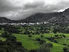
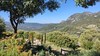
In this area large Roman settlements were found (Palatina Ocuri, Acinipo) and many Roman Roads can be walked. Pretty tough hikes.
You may be viewing yesterday's version of this page. To see the most up to date information please register for a free account.
")
Do not use the above information on other web sites or publications without permission of the contributor.
Nearby Images from Flickr


The above images may not be of the site on this page, but were taken nearby. They are loaded from Flickr so please click on them for image credits.
Click here to see more info for this site
Nearby sites
Click here to view sites on an interactive map of the areaKey: Red: member's photo, Blue: 3rd party photo, Yellow: other image, Green: no photo - please go there and take one, Grey: site destroyed
Download sites to:
KML (Google Earth)
GPX (GPS waypoints)
CSV (Garmin/Navman)
CSV (Excel)
To unlock full downloads you need to sign up as a Contributory Member. Otherwise downloads are limited to 50 sites.
Turn off the page maps and other distractions
Nearby sites listing. In the following links * = Image available
640m NNW 333° Ciudad Palatina Ocuri Ancient Village or Settlement
11.1km NE 39° Caldaza Medieval Trackway* Ancient Trackway
15.6km E 86° La Pileta* Cave or Rock Shelter
19.1km NE 54° Ronda Dolmen* Burial Chamber or Dolmen
20.3km E 96° Dólmen del Cortijo de la Mimbre Burial Chamber or Dolmen
20.4km E 92° Dólmen de Monteiro* Burial Chamber or Dolmen
21.0km NNE 31° Dolmen El Charcón* Burial Chamber or Dolmen
21.0km E 90° Encinas Boracchas* Burial Chamber or Dolmen
21.0km E 90° Dolmen del puerto de Encinas Borrachas* Burial Chamber or Dolmen
21.2km NNE 30° El Charcón II* Burial Chamber or Dolmen
21.6km NW 305° Menhir de La Lancha* Standing Stone (Menhir)
22.7km NW 311° Alberite Dolmen* Chambered Tomb
24.8km NE 48° Acinipo* Ancient Village or Settlement
25.8km ENE 75° Water Mine / Fortress Ronda* Ancient Mine, Quarry or other Industry
27.6km S 182° Castillo de Jimena de la Frontera* Hillfort
28.1km S 183° Chinchilla* Ancient Village or Settlement
29.4km SSE 155° Ruinas Romanas de Lacipo* Ancient Village or Settlement
33.5km SE 141° Necrópolis Prehistórica de Corominas* Museum
40.4km NE 43° Dólmen de los Tomillos 1* Burial Chamber or Dolmen
40.4km NE 43° Dólmen de los Tomillos 2* Burial Chamber or Dolmen
40.4km NE 43° Dólmen de los Tomillos 3* Chambered Tomb
42.5km SE 127° Villa Romana de las Torres* Ancient Village or Settlement
44.1km ENE 74° Dólmen del Cerro de la Cruz Blanca Burial Chamber or Dolmen
44.8km SSE 163° Yacimiento Arqueológico Barbesula Ancient Village or Settlement
48.1km SSW 213° Cueva Tajo de Las Figuras Cave or Rock Shelter
View more nearby sites and additional images


 We would like to know more about this location. Please feel free to add a brief description and any relevant information in your own language.
 Wir möchten mehr über diese Stätte erfahren. Bitte zögern Sie nicht, eine kurze Beschreibung und relevante Informationen in Deutsch hinzuzufügen.
 Nous aimerions en savoir encore un peu sur les lieux. S'il vous plaît n'hesitez pas à ajouter une courte description et tous les renseignements pertinents dans votre propre langue.
 Quisieramos informarnos un poco más de las lugares. No dude en añadir una breve descripción y otros datos relevantes en su propio idioma.