

<< Our Photo Pages >> Comar Wood - Stone Fort or Dun in Scotland in Highlands
Submitted by Andy B on Thursday, 01 March 2018 Page Views: 11081
Multi-periodSite Name: Comar Wood Alternative Name: Strath GlassCountry: Scotland
NOTE: This site is 14.0 km away from the location you searched for.
County: Highlands Type: Stone Fort or Dun
Nearest Town: Inverness Nearest Village: Cannich
Map Ref: NH3250931008
Latitude: 57.338723N Longitude: 4.784499W
Condition:
| 5 | Perfect |
| 4 | Almost Perfect |
| 3 | Reasonable but with some damage |
| 2 | Ruined but still recognisable as an ancient site |
| 1 | Pretty much destroyed, possibly visible as crop marks |
| 0 | No data. |
| -1 | Completely destroyed |
| 5 | Superb |
| 4 | Good |
| 3 | Ordinary |
| 2 | Not Good |
| 1 | Awful |
| 0 | No data. |
| 5 | Can be driven to, probably with disabled access |
| 4 | Short walk on a footpath |
| 3 | Requiring a bit more of a walk |
| 2 | A long walk |
| 1 | In the middle of nowhere, a nightmare to find |
| 0 | No data. |
| 5 | co-ordinates taken by GPS or official recorded co-ordinates |
| 4 | co-ordinates scaled from a detailed map |
| 3 | co-ordinates scaled from a bad map |
| 2 | co-ordinates of the nearest village |
| 1 | co-ordinates of the nearest town |
| 0 | no data |
Internal Links:
External Links:
")
See comments below for the latest updates.
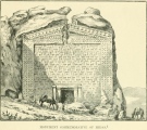
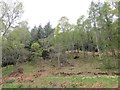
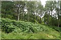
Matt Ritchie, Forestry Commission Archaeologist describes the site: This likely late prehistoric galleried dun measures 11m in diameter within a massive drystone wall c. 4.8m in thickness and up to 1.8m in height. It is situated on a knoll on a slight terrace on the lower SE-facing slopes of Strath Glass, above and to the NE of the River Glass. The dun is well preserved, with several stretches of wall courses visible both externally and internally.
There is an entrance on the W, which measures c.1.8m in width; and several likely galleries are visible as depressions within the wall. An outwork is visible enclosing the dun on its N, S and W sides; this wall measures c. 2.5m in thickness and up to 1.5m in height. An entrance is visible on its NE side. The ESE-facing leading edge of the terrace is defined by steep rock outcrops. Two small post medieval buildings have been built into the spread tumble from the dun and its outwork.
Archaeological Context
The Atlantic coast of Europe in the later first millennium BC is dominated by small defended enclosures. All would appear to be variations on a simple theme and examples can be found from the northern isles of Scotland down to Galicia and northern Portugal. The impressive brochs (the pinnacle of a building type known as the complex round house), fortified duns (simple stone-built strongholds) and crannogs (artificial islands constructed to support a timber building or stone dun) of Scotland all form part of the same Iron Age settlement tradition. Such homesteads were a very visible symbol of land tenure and served to defend their occupants – but also protected their grain and stock.
The dun at Comar Wood is a well preserved example of a galleried dun - the depressions visible within its stout walls likely represent galleries or chambers. Comar Wood is also unusual on account of its well defined defensive outwork. Although the dun may not have stood much more than 1m in height internally, it would once have boasted an external wall face that stood up to 3m in height. The thick walls very likely supported a single conical thatched roof. The site has much archaeological potential: buried occupation deposits and structural evidence both internal and external to the dun.
Matt Ritchie, FCS Archaeologist, 14/12/09
More about the site and how the felling was done
The dun - part of an Iron Age building tradition common throughout the Highlands and islands of Scotland – would have served as a homestead defending their occupants - and their grain and livestock – but also demonstrating land ownership.
Matt Ritchie, said: “This is really a find of national significance and it was important that we preserved the site and prevented it being damaged while felling operations were being carried out.
“It was quite a delicate task because the dun is about 21m in diameter overall and we had to clear 23 fully mature trees from it.”
Working with specialist contractor, Highland Tree Care, the Commission’s team rigged up a rope cradle that effectively acted as a brake, catching the trees and lowering them slowly to the ground for processing.
Matt added: “It was a quick and successful operation. I’m really pleased that we managed to get those trees out of there with out causing any damage to the site.
“There are no plans to excavate or restore the site, but we will recommend the site to Historic Scotland for scheduling. It is relatively undisturbed and there are likely going to be significant buried archaeological deposits throughout. “A very interesting and important site!”
Unknown and unrecognized when the site was planted in the 1950s, the dun is defined by a defensive outwork enclosing the dun and a massive dry-stone wall, with internal and external courses visible at several stretches. Depressions in the wall also mark the positions of galleries.
The Commission will now focus on keeping the immediate area around the site clear of trees and scrub vegetation.
The soft-felling technique involves stringing a rope cradle between two shackles on slings attached to two spar trees. A counter balance log is then attached at one end of the ‘arrester rope’ to slow the felled tree(s) safely; the other end is wrapped around the trunk of a nearby tree and ‘locked off’. The felled tree is lowered by gradually readjusting the wrapped loose end of the rope and processed at a good working height: where possible, long saw logs were left for later pick-up by Harvester, while in other cases the tree was cut into small pieces and removed by hand.
Source: Forestry Commission with additional input from Matt Ritchie, Forestry Commission Archaeologist
Note: Archaeologists excavate Iron-Age broch or dun-house which was burnt down twice and has a strange lack of artefacts, see the most recent comment on our page
You may be viewing yesterday's version of this page. To see the most up to date information please register for a free account.
")
")
")
Do not use the above information on other web sites or publications without permission of the contributor.
Nearby Images from Geograph Britain and Ireland:
©2005(licence)
©2022(licence)
©2018(licence)
©2014(licence)
©2017(licence)
The above images may not be of the site on this page, they are loaded from Geograph.
Please Submit an Image of this site or go out and take one for us!
Click here to see more info for this site
Nearby sites
Key: Red: member's photo, Blue: 3rd party photo, Yellow: other image, Green: no photo - please go there and take one, Grey: site destroyed
Download sites to:
KML (Google Earth)
GPX (GPS waypoints)
CSV (Garmin/Navman)
CSV (Excel)
To unlock full downloads you need to sign up as a Contributory Member. Otherwise downloads are limited to 50 sites.
Turn off the page maps and other distractions
Nearby sites listing. In the following links * = Image available
5.1km E 98° Mony's Stone* Standing Stone (Menhir) (NH3751530072)
5.8km E 95° Corrimony* Clava Cairn (NH38303029)
5.9km E 94° Corrimony mound Artificial Mound (NH38383038)
5.9km NE 48° St Ignatius' Well* Holy Well or Sacred Spring (NH3709934761)
6.2km E 88° Curadan's Well* Holy Well or Sacred Spring (NH38753102)
7.3km E 88° Buntait Cup Marked Stone* Rock Art (NH39793102)
11.3km NE 37° Dun Coille Struy Broch or Nuraghe (NH39643976)
16.1km ESE 124° Boulder near Creag Dhearg Natural Stone / Erratic / Other Natural Feature (NH456215)
16.9km E 86° Clachmhor, Culnakirk* Rock Art (NH49443145)
16.9km E 86° Carn Daley* Clava Cairn (NH4945431458)
18.8km ENE 61° Boblainy* Stone Circle (NH49343951)
19.7km NE 55° Culburnie* Stone Circle (NH491418)
20.3km ENE 57° Bruiach* Cairn (NH49984143)
20.4km E 90° Holy Well (Drumnadrochit)* Holy Well or Sacred Spring (NH530300)
21.6km ENE 60° Meg's Stone* Standing Stone (Menhir) (NH5164541196)
21.6km SSE 162° Cherry Island* Crannog (NH385102)
21.8km ENE 59° Belladrum South Chambered Tomb (NH5161041578)
21.9km ENE 57° Belladrum Chambered Cairn* Chambered Cairn (NH5141742120)
21.9km ENE 62° Allt Eoghainn* Chambered Tomb (NH5236240392)
22.1km W 265° Glen Cannich hut circles Ancient Village or Settlement (NH104301)
22.2km NE 50° Ballblair Wood Chambered Cairn (NH502445)
24.2km ENE 61° Castle Spynie Broch or Nuraghe (NH54144204)
24.4km NE 37° Cnoc Udais Cairn* Cairn (NH48154984)
25.8km ENE 59° Balblair Class I Pictish Symbol Stone (NH55184357)
26.5km ENE 59° Giant's Grave (Highlands) Chambered Cairn (NH55904369)
View more nearby sites and additional images


 We would like to know more about this location. Please feel free to add a brief description and any relevant information in your own language.
 Wir möchten mehr über diese Stätte erfahren. Bitte zögern Sie nicht, eine kurze Beschreibung und relevante Informationen in Deutsch hinzuzufügen.
 Nous aimerions en savoir encore un peu sur les lieux. S'il vous plaît n'hesitez pas à ajouter une courte description et tous les renseignements pertinents dans votre propre langue.
 Quisieramos informarnos un poco más de las lugares. No dude en añadir una breve descripción y otros datos relevantes en su propio idioma.