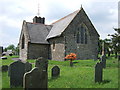
<< Text Pages >> Maenclochog Church - Early Christian Sculptured Stone in Wales in Pembrokeshire
Submitted by vicky on Monday, 24 March 2003 Page Views: 5395
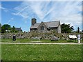
Early Medieval (Dark Age)Site Name: Maenclochog ChurchCountry: Wales
NOTE: This site is 0.197 km away from the location you searched for.
County: Pembrokeshire Type: Early Christian Sculptured Stone
Nearest Village: Maenclochog
Map Ref: SN082273 Landranger Map Number: 145
Latitude: 51.911121N Longitude: 4.789929W
Condition:
| 5 | Perfect |
| 4 | Almost Perfect |
| 3 | Reasonable but with some damage |
| 2 | Ruined but still recognisable as an ancient site |
| 1 | Pretty much destroyed, possibly visible as crop marks |
| 0 | No data. |
| -1 | Completely destroyed |
| 5 | Superb |
| 4 | Good |
| 3 | Ordinary |
| 2 | Not Good |
| 1 | Awful |
| 0 | No data. |
| 5 | Can be driven to, probably with disabled access |
| 4 | Short walk on a footpath |
| 3 | Requiring a bit more of a walk |
| 2 | A long walk |
| 1 | In the middle of nowhere, a nightmare to find |
| 0 | No data. |
| 5 | co-ordinates taken by GPS or official recorded co-ordinates |
| 4 | co-ordinates scaled from a detailed map |
| 3 | co-ordinates scaled from a bad map |
| 2 | co-ordinates of the nearest village |
| 1 | co-ordinates of the nearest town |
| 0 | no data |
Internal Links:
External Links:
I have visited· I would like to visit
geoffstickland has visited here
Have you visited this site? Please add a comment below.
You may be viewing yesterday's version of this page. To see the most up to date information please register for a free account.
")
Do not use the above information on other web sites or publications without permission of the contributor.
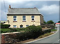
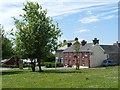
Nearby Images from Geograph Britain and Ireland:
©2007(licence)
©2007(licence)
©2010(licence)
©2007(licence)
©2010(licence)
The above images may not be of the site on this page, they are loaded from Geograph.
Please Submit an Image of this site or go out and take one for us!
Click here to see more info for this site
Nearby sites
Key: Red: member's photo, Blue: 3rd party photo, Yellow: other image, Green: no photo - please go there and take one, Grey: site destroyed
Download sites to:
KML (Google Earth)
GPX (GPS waypoints)
CSV (Garmin/Navman)
CSV (Excel)
To unlock full downloads you need to sign up as a Contributory Member. Otherwise downloads are limited to 50 sites.
Turn off the page maps and other distractions
Nearby sites listing. In the following links * = Image available
465m SSW 203° Cilmoor Stone* Standing Stone (Menhir) (SN08002688)
681m N 354° Maenclochog Standing Stones* Standing Stones (SN08152798)
716m WSW 248° St Mary's Well (Maenclochog)* Holy Well or Sacred Spring (SN0752527055)
742m NE 45° Galchen Fach* Standing Stones (SN08752780)
1.2km SE 124° Castell Forlan Ancient Village or Settlement (SN09202657)
1.4km NNW 349° Eithbed Tombs* Chambered Tomb (SN07982864)
1.4km E 92° Temple Druid Henge (SN096272)
1.4km N 352° Eithbed Enclosure* Ancient Village or Settlement (SN08052871)
1.5km E 94° Temple Druid Standing Stone* Standing Stone (Menhir) (SN0965427147)
1.5km E 95° Prysg Farm Stone* Standing Stone (Menhir) (SN0968327102)
1.7km E 88° Temple Druid Modern Stone Circle etc (SN099273)
1.8km NNE 20° Eithbed Stone Standing Stone (Menhir) (SN089290)
1.9km E 97° St Teilo's Well* Holy Well or Sacred Spring (SN101270)
2.0km N 357° Eithbed Cairn* Ring Cairn (SN08172927)
2.0km NW 305° Budloy Stone* Standing Stone (Menhir) (SN06562853)
2.1km NNE 26° Eithbed Circles* Stone Circle (SN092292)
2.5km WNW 295° Dyffryn Syfynwy* Stone Circle (SN05922845)
2.6km NNE 18° Mynydd Crwn Standing Stone Standing Stone (Menhir) (SN091297)
2.9km WNW 282° St Brynach's Well* Holy Well or Sacred Spring (SN054280)
3.0km N 5° Cnwc Barrow 2 Round Barrow(s) (SN086303)
3.2km ENE 70° Parc Maen Barrow Round Barrow(s) (SN113283)
3.2km ENE 70° Parc Maen Stone* Standing Stone (Menhir) (SN113283)
3.3km N 8° Cnwc Barrow 1 Round Barrow(s) (SN088305)
3.3km NW 308° Bernard's Well Mountain* Ancient Village or Settlement (SN057294)
3.4km E 96° Maen Colman Cross Stone* Early Christian Sculptured Stone (SN116268)
View more nearby sites and additional images


 We would like to know more about this location. Please feel free to add a brief description and any relevant information in your own language.
 Wir möchten mehr über diese Stätte erfahren. Bitte zögern Sie nicht, eine kurze Beschreibung und relevante Informationen in Deutsch hinzuzufügen.
 Nous aimerions en savoir encore un peu sur les lieux. S'il vous plaît n'hesitez pas à ajouter une courte description et tous les renseignements pertinents dans votre propre langue.
 Quisieramos informarnos un poco más de las lugares. No dude en añadir una breve descripción y otros datos relevantes en su propio idioma.