<< Our Photo Pages >> Quethiock Cross - Ancient Cross in England in Cornwall
Submitted by lucasn on Thursday, 11 June 2020 Page Views: 845
Early Medieval (Dark Age)Site Name: Quethiock CrossCountry: England
NOTE: This site is 0.268 km away from the location you searched for.
County: Cornwall Type: Ancient Cross
Nearest Town: Liskeard Nearest Village: Quethiock
Map Ref: SX31296471
Latitude: 50.457898N Longitude: 4.378145W
Condition:
| 5 | Perfect |
| 4 | Almost Perfect |
| 3 | Reasonable but with some damage |
| 2 | Ruined but still recognisable as an ancient site |
| 1 | Pretty much destroyed, possibly visible as crop marks |
| 0 | No data. |
| -1 | Completely destroyed |
| 5 | Superb |
| 4 | Good |
| 3 | Ordinary |
| 2 | Not Good |
| 1 | Awful |
| 0 | No data. |
| 5 | Can be driven to, probably with disabled access |
| 4 | Short walk on a footpath |
| 3 | Requiring a bit more of a walk |
| 2 | A long walk |
| 1 | In the middle of nowhere, a nightmare to find |
| 0 | No data. |
| 5 | co-ordinates taken by GPS or official recorded co-ordinates |
| 4 | co-ordinates scaled from a detailed map |
| 3 | co-ordinates scaled from a bad map |
| 2 | co-ordinates of the nearest village |
| 1 | co-ordinates of the nearest town |
| 0 | no data |
Internal Links:
External Links:
I have visited· I would like to visit
lucasn visited - their rating: Cond: 4 Amb: 3 Access: 5
")
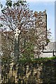
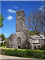
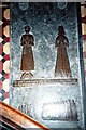
The cross was lost for many years until it was uncovered in 1881 during excavations of the churchyard. Only the head and base were originally found, deeply buried under the churchyard, and after a search for the shaft of the cross, it was eventually found in use as a gatepost for a blocked, disused entrance to the churchyard. The shaft, head and base were all joined together, and the cross was re-erected where it stands today, south of the church porch.
The cross is beautifully carved both down the shaft and on the cross head, although two cracks can be seen where the cross was originally joined together. It's amazing to think how such an impressive cross laid below ground, unknown about for who knows how many years.
You may be viewing yesterday's version of this page. To see the most up to date information please register for a free account.
Do not use the above information on other web sites or publications without permission of the contributor.
Nearby Images from Geograph Britain and Ireland:
©2007(licence)
©2014(licence)
©2014(licence)
©2023(licence)
©2013(licence)
The above images may not be of the site on this page, they are loaded from Geograph.
Please Submit an Image of this site or go out and take one for us!
Click here to see more info for this site
Nearby sites
Key: Red: member's photo, Blue: 3rd party photo, Yellow: other image, Green: no photo - please go there and take one, Grey: site destroyed
Download sites to:
KML (Google Earth)
GPX (GPS waypoints)
CSV (Garmin/Navman)
CSV (Excel)
To unlock full downloads you need to sign up as a Contributory Member. Otherwise downloads are limited to 50 sites.
Turn off the page maps and other distractions
Nearby sites listing. In the following links * = Image available
3.2km NE 55° Collects Well* Holy Well or Sacred Spring (SX3399466483)
3.7km S 177° Padderbury Top Ancient Village or Settlement (SX3139661023)
4.0km NE 44° Cadson Bury* Hillfort (SX342675)
5.2km NE 39° Frogwell* Holy Well or Sacred Spring (SX347686)
6.1km W 265° Pipe Well* Holy Well or Sacred Spring (SX252644)
6.4km NNW 334° Roundabury* Hillfort (SX28627056)
6.7km NE 41° Lady's Well (Callington)* Holy Well or Sacred Spring (SX359696)
6.7km NW 306° Trethevy Quoit* Burial Chamber or Dolmen (SX2593668813)
6.9km NE 55° Castlewitch Henge* Henge (SX37086854)
7.0km NNW 340° St John's Well (Caradon)* Holy Well or Sacred Spring (SX291714)
7.1km NW 319° Caradon Hill stone row Stone Row / Alignment (SX26797016)
7.2km NW 324° Caradon Hill cairns* Barrow Cemetery (SX272707)
7.3km WNW 298° St Cleer's Well* Holy Well or Sacred Spring (SX249683)
7.3km WNW 298° St Cleer Well Cross* Ancient Cross (SX249683)
7.4km WNW 295° Church of St Clarus* Early Christian Sculptured Stone (SX247681)
7.6km NE 51° Dupath Well* Holy Well or Sacred Spring (SX374693)
7.7km NNE 17° Lower Manaton Holy Well or Sacred Spring (SX3377072033)
7.8km SSW 206° Bin Down (East Looe)* Ancient Village or Settlement (SX2764957830)
7.8km SW 234° St Keyne's Well* Holy Well or Sacred Spring (SX248603)
8.0km SSE 147° Venton Gwavas* Holy Well or Sacred Spring (SX355579)
8.2km NW 314° The Long Stone (Minions)* Standing Stone (Menhir) (SX25547055)
8.3km NW 319° Minions Mound* Round Barrow(s) (SX26017112)
8.4km NW 317° Minions Platform Round Barrow* Cairn (SX25787109)
8.4km NW 314° Minions Cairns Cairn (SX25357073)
8.5km N 2° St Melor's Well* Holy Well or Sacred Spring (SX319732)
View more nearby sites and additional images


 We would like to know more about this location. Please feel free to add a brief description and any relevant information in your own language.
 Wir möchten mehr über diese Stätte erfahren. Bitte zögern Sie nicht, eine kurze Beschreibung und relevante Informationen in Deutsch hinzuzufügen.
 Nous aimerions en savoir encore un peu sur les lieux. S'il vous plaît n'hesitez pas à ajouter une courte description et tous les renseignements pertinents dans votre propre langue.
 Quisieramos informarnos un poco más de las lugares. No dude en añadir una breve descripción y otros datos relevantes en su propio idioma.