<< Text Pages >> Y Naw Carreg - Stone Circle in Wales in Carmarthenshire
Submitted by vicky on Sunday, 22 September 2002 Page Views: 11050
Neolithic and Bronze AgeSite Name: Y Naw CarregCountry: Wales
NOTE: This site is 0.902 km away from the location you searched for.
County: Carmarthenshire Type: Stone Circle
Map Ref: SN58111130 Landranger Map Number: 159
Latitude: 51.782321N Longitude: 4.058328W
Condition:
| 5 | Perfect |
| 4 | Almost Perfect |
| 3 | Reasonable but with some damage |
| 2 | Ruined but still recognisable as an ancient site |
| 1 | Pretty much destroyed, possibly visible as crop marks |
| 0 | No data. |
| -1 | Completely destroyed |
| 5 | Superb |
| 4 | Good |
| 3 | Ordinary |
| 2 | Not Good |
| 1 | Awful |
| 0 | No data. |
| 5 | Can be driven to, probably with disabled access |
| 4 | Short walk on a footpath |
| 3 | Requiring a bit more of a walk |
| 2 | A long walk |
| 1 | In the middle of nowhere, a nightmare to find |
| 0 | No data. |
| 5 | co-ordinates taken by GPS or official recorded co-ordinates |
| 4 | co-ordinates scaled from a detailed map |
| 3 | co-ordinates scaled from a bad map |
| 2 | co-ordinates of the nearest village |
| 1 | co-ordinates of the nearest town |
| 0 | no data |
Internal Links:
External Links:
I have visited· I would like to visit
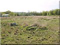
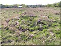
nddavies visited on 22nd Apr 2011 - their rating: Cond: 2 Access: 4 Three stones and the central mound remain in a pasture field. The stones have all fallen. Drainage seems poor - it was a bone dry day but the reeds hint at soggy ground.
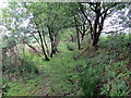
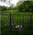
Access from the northwest may be problematic. The stile out from the field looked overgrown. Access is easy from the 4-way junction of paths just southeast. Approach this junction from the good paths west or southeast.
See photos on Geograph http://www.geograph.org.uk/photo/2377857 & http://www.geograph.org.uk/photo/2377858
According to Burl this circle is destroyed or unrecognisable. Have you visited this site? Please leave your comments below.
You may be viewing yesterday's version of this page. To see the most up to date information please register for a free account.
Do not use the above information on other web sites or publications without permission of the contributor.
Nearby Images from Geograph Britain and Ireland:
©2011(licence)
©2011(licence)
©2018(licence)
©2009(licence)
©2013(licence)
The above images may not be of the site on this page, they are loaded from Geograph.
Please Submit an Image of this site or go out and take one for us!
Click here to see more info for this site
Nearby sites
Key: Red: member's photo, Blue: 3rd party photo, Yellow: other image, Green: no photo - please go there and take one, Grey: site destroyed
Download sites to:
KML (Google Earth)
GPX (GPS waypoints)
CSV (Garmin/Navman)
CSV (Excel)
To unlock full downloads you need to sign up as a Contributory Member. Otherwise downloads are limited to 50 sites.
Turn off the page maps and other distractions
Nearby sites listing. In the following links * = Image available
3.0km SSE 165° Bryn-Y-Rhyd* Standing Stone (Menhir) (SN5883008362)
4.0km NNE 33° Tireinion Enclosure Hillfort (SN60401464)
5.0km ENE 71° Ammanford Gorsedd Stone Circle* Modern Stone Circle etc (SN62931282)
5.2km NNE 20° Ffynnon Gwenlais* Holy Well or Sacred Spring (SN600161)
5.2km SSW 208° Brynmaen Standing Stone* Standing Stone (Menhir) (SN5552706764)
5.8km SSE 150° Graig Fawr* Chambered Tomb (SN60840620)
6.2km NNE 24° Pant-y-Llyn Boulder* Natural Stone / Erratic / Other Natural Feature (SN60821684)
6.2km WNW 302° Capel Erbach* Holy Well or Sacred Spring (SN52951472)
6.3km SE 128° Graig Fawr Burnt Mound Misc. Earthwork (SN63000728)
6.4km SE 127° Graig Fawr (East) Burnt Mound Misc. Earthwork (SN63080729)
6.6km SE 134° Graig Fawr Ring Cairn* Ring Cairn (SN628066)
6.7km SW 220° Ffynnon Diolch I Dduw* Holy Well or Sacred Spring (SN536063)
6.7km ESE 119° Blaenffynhonnau Hut Circle Ancient Village or Settlement (SN63900783)
7.1km NE 40° Pistyll Mountain Cairn* Cairn (SN62791662)
7.1km ESE 114° Pentwyn Mawr Round Cairn (SN64530826)
7.6km N 355° Berrach Earthwork Misc. Earthwork (SN576189)
7.7km WNW 295° Capel Begewdin Holy Well or Sacred Spring (SN5115314712)
7.8km NNE 23° Pant-Y-Llyn Burnt Mounds Artificial Mound (SN613184)
7.9km NE 38° Pistyll-Ganol Cairn 2* Cairn (SN6314017355)
7.9km NE 38° Pistyll-Ganol Cairn 1* Cairn (SN6315817360)
8.2km E 83° Bodyst Uchaf ring cairn* Ring Cairn (SN66281213)
8.4km NE 44° Ffynnon Gwyddfan* Holy Well or Sacred Spring (SN6416117112)
8.4km SE 140° Mynydd Pysgodlyn Cairn Cairn (SN63400475)
8.4km SE 139° Penlle'r Bebyll* Ring Cairn (SN63510482)
8.5km ENE 60° Brownhill Round Barrow* Cairn (SN65551535)
View more nearby sites and additional images


 We would like to know more about this location. Please feel free to add a brief description and any relevant information in your own language.
 Wir möchten mehr über diese Stätte erfahren. Bitte zögern Sie nicht, eine kurze Beschreibung und relevante Informationen in Deutsch hinzuzufügen.
 Nous aimerions en savoir encore un peu sur les lieux. S'il vous plaît n'hesitez pas à ajouter une courte description et tous les renseignements pertinents dans votre propre langue.
 Quisieramos informarnos un poco más de las lugares. No dude en añadir una breve descripción y otros datos relevantes en su propio idioma.