

<< Our Photo Pages >> Tullybannocher - Stone Circle in Scotland in Perth and Kinross
Submitted by Tom_Bullock on Sunday, 14 July 2002 Page Views: 7831
Neolithic and Bronze AgeSite Name: Tullybannocher Alternative Name: Comrie, Wester TullybanocherCountry: Scotland County: Perth and Kinross Type: Stone Circle
Nearest Town: Perth Nearest Village: Comrie
Map Ref: NN75482247 Landranger Map Number: 51
Latitude: 56.378070N Longitude: 4.017969W
Condition:
| 5 | Perfect |
| 4 | Almost Perfect |
| 3 | Reasonable but with some damage |
| 2 | Ruined but still recognisable as an ancient site |
| 1 | Pretty much destroyed, possibly visible as crop marks |
| 0 | No data. |
| -1 | Completely destroyed |
| 5 | Superb |
| 4 | Good |
| 3 | Ordinary |
| 2 | Not Good |
| 1 | Awful |
| 0 | No data. |
| 5 | Can be driven to, probably with disabled access |
| 4 | Short walk on a footpath |
| 3 | Requiring a bit more of a walk |
| 2 | A long walk |
| 1 | In the middle of nowhere, a nightmare to find |
| 0 | No data. |
| 5 | co-ordinates taken by GPS or official recorded co-ordinates |
| 4 | co-ordinates scaled from a detailed map |
| 3 | co-ordinates scaled from a bad map |
| 2 | co-ordinates of the nearest village |
| 1 | co-ordinates of the nearest town |
| 0 | no data |
Internal Links:
External Links:
I have visited· I would like to visit
Uralsdaughter visited on 22nd Aug 2018 - their rating: Cond: 3 Amb: 4 Access: 4
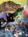
Anne T visited on 28th Sep 2017 - their rating: Cond: 3 Amb: 4 Access: 4 Wester Tullybannocher Stone Circle, Comrie: From the Dalginross/Dunmoid Four Poster Stone Circle, we made our way north through Comrie, heading west on the A85, over Dalginross Bridge then turning left. The road goes through a zig-zag then a bend, passing a caravan park on the right hand side at Twenty Shilling Wood. Just after the road turns a right hand bend there is a farm track to your right hand side, with room for a car to pull in before the gate (on opening the gate there is a small area of hard-standing for a couple of cars). We parked just in front of the gate and walked along the farm track to the stones, which were peeping out of knee high grass in the un cultivated part of the field to our left hand side.
We couldn’t spot any cup marks on the western stone, despite walking round the stones several times. Sited on flat pastureland with low hills rising around, and lying just north of the River Earn, this is a lovely spot, although a little spoiled by the heavy traffic on the A85 just to the south of the stones.
SolarMegalith visited on 10th Aug 2017 - their rating: Cond: 2 Amb: 3 Access: 4
MegalithicDania saw from a distance on 1st Jul 2016 - their rating: Cond: 2 Amb: 4 Access: 4
hamish have visited here
Average ratings for this site from all visit loggers: Condition: 2.5 Ambience: 3.75 Access: 4
")
For more information see Canmore site no. 24858, which records an entry from 1911 which reads: "Only two stones remain of this stone circle although there were three up to c.1883 when one fell down and was removed. The stones are 22' apart and 5' and 4'8" high respectively."
They added a further note in 1966 saying: "the western stone has at least four cup-marks."
You may be viewing yesterday's version of this page. To see the most up to date information please register for a free account.
")
")
")
")
")
")
")
")
")
")
")
")
")
")
")
")
")
")
")
")
")
")
")
")
These are just the first 25 photos of Tullybannocher. If you log in with a free user account you will be able to see our entire collection.
Do not use the above information on other web sites or publications without permission of the contributor.
Click here to see more info for this site
Nearby sites
Key: Red: member's photo, Blue: 3rd party photo, Yellow: other image, Green: no photo - please go there and take one, Grey: site destroyed
Download sites to:
KML (Google Earth)
GPX (GPS waypoints)
CSV (Garmin/Navman)
CSV (Excel)
To unlock full downloads you need to sign up as a Contributory Member. Otherwise downloads are limited to 50 sites.
Turn off the page maps and other distractions
Nearby sites listing. In the following links * = Image available
1.3km SE 141° Craggish (Comrie) Standing Stones (NN763214)
1.6km WNW 288° Cluan-Glasdale Stone Circle (NN7423)
1.6km ESE 106° Tom na Chessaig Stone Circle (NN770220)
1.6km SE 144° Comrie Cursus Cursus (NN76422112)
1.9km SSE 154° Craggish Stone Row / Alignment (NN763207)
2.1km E 91° Coney Hill (Comrie)* Misc. Earthwork (NN77552238)
2.7km SE 137° Comrie Cursus Cursus (NN77252048)
2.7km SE 131° West Cowden* Stone Row / Alignment (NN7744520645)
2.8km SE 134° Comrie Cursus Cursus (NN77422047)
2.8km ESE 114° Dalginross* Stone Circle (NN7802521264)
3.2km W 278° Loch Earn Chambered Cairn (NN723230)
3.3km W 281° Kindrochat Chambered Cairn (NN722232)
3.9km NE 46° Balmuick* Stone Circle (NN78362513)
4.3km SE 130° Auchingarrich Farm Standing Stone (Menhir) (NN78731958)
4.6km E 86° Lawers* Standing Stone (Menhir) (NN80102267)
4.7km W 278° St Fillan's Chair (Dundurn) Natural Stone / Erratic / Other Natural Feature (NN70812325)
4.7km W 278° St Fillan's Well (Comrie) Holy Well or Sacred Spring (NN70802327)
5.2km W 281° St Fillan's Chapel (Comrie)* Ancient Cross (NN7038323579)
5.4km WNW 286° Little Port* Standing Stone (Menhir) (NN70342415)
5.7km SSE 147° Giant's Knowe (Culloch) Cairn (NN78481762)
5.8km E 82° Clathick House Standing Stone (Menhir) (NN81212315)
5.9km SE 139° Craigneich Farm* Standing Stone (Menhir) (NN7922617871)
6.4km SE 144° Dunruchan C (Muthill)* Standing Stone (Menhir) (NN7910817137)
6.6km ESE 103° Strowan (Crieff)* Cairn (NN819208)
6.6km SE 146° Dunruchan D (Muthill)* Standing Stone (Menhir) (NN7904416881)
View more nearby sites and additional images


 We would like to know more about this location. Please feel free to add a brief description and any relevant information in your own language.
 Wir möchten mehr über diese Stätte erfahren. Bitte zögern Sie nicht, eine kurze Beschreibung und relevante Informationen in Deutsch hinzuzufügen.
 Nous aimerions en savoir encore un peu sur les lieux. S'il vous plaît n'hesitez pas à ajouter une courte description et tous les renseignements pertinents dans votre propre langue.
 Quisieramos informarnos un poco más de las lugares. No dude en añadir una breve descripción y otros datos relevantes en su propio idioma.