

<< Our Photo Pages >> St Fillan's Chapel (Comrie) - Ancient Cross in Scotland in Perth and Kinross
Submitted by Anne T on Wednesday, 11 October 2017 Page Views: 2292
Early Medieval (Dark Age)Site Name: St Fillan's Chapel (Comrie) Alternative Name: St Fillian's ChapelCountry: Scotland County: Perth and Kinross Type: Ancient Cross
Nearest Town: Comrie Nearest Village: St Fillans
Map Ref: NN7038323579
Latitude: 56.386657N Longitude: 4.100992W
Condition:
| 5 | Perfect |
| 4 | Almost Perfect |
| 3 | Reasonable but with some damage |
| 2 | Ruined but still recognisable as an ancient site |
| 1 | Pretty much destroyed, possibly visible as crop marks |
| 0 | No data. |
| -1 | Completely destroyed |
| 5 | Superb |
| 4 | Good |
| 3 | Ordinary |
| 2 | Not Good |
| 1 | Awful |
| 0 | No data. |
| 5 | Can be driven to, probably with disabled access |
| 4 | Short walk on a footpath |
| 3 | Requiring a bit more of a walk |
| 2 | A long walk |
| 1 | In the middle of nowhere, a nightmare to find |
| 0 | No data. |
| 5 | co-ordinates taken by GPS or official recorded co-ordinates |
| 4 | co-ordinates scaled from a detailed map |
| 3 | co-ordinates scaled from a bad map |
| 2 | co-ordinates of the nearest village |
| 1 | co-ordinates of the nearest town |
| 0 | no data |
Internal Links:
External Links:
I have visited· I would like to visit
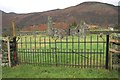
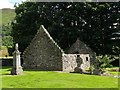
Anne T visited on 28th Sep 2017 - their rating: Cond: 2 Amb: 4 Access: 4 St. Fillan's Chapel, west of Comrie: From Wester Tullybannocher Stone Circle, we carried on west along the A85, turning left into a road leading down to St. Fillan’s Golf Club and Western Dundurn Farm. Just before the farm buildings, the track splits. The eastern most track is gated off, and the road was very narrow, so we squeezed the car in by the gate intending to run back and move it if it got in the way. There was a herd of cattle in the field, although the churchyard has a dry stone wall around it.
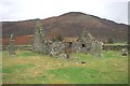
Walking along the track, watched curiously by the golfers on the adjacent course, until I was level with the church ruins (very like Logie Old Kirk), then squidged my way through the wet turf to the far side, where the iron gate to the churchyard was locked, but there was a stone stile into the graveyard.
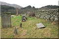
This is a very, very pretty spot. It is a very old site. Typically, there was no phone signal here so I couldn’t call up the Canmore record. I went round photographing lots of different things. I managed to miss the recumbent cross slab (most of them were overgrown with grass), although there were a couple of other interesting stones and features. Lovely site but disappointing not to have found the cross slab, even though I must have looked at it.
Also known as St Fillian's; Dundurn Burial-ground; Stewarts Of Ardvoirlich Burial-place.
 (PID:172447)")
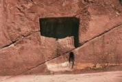
This early medieval cross slab has been recorded as part of Canmore ID 24872. Canmore tell us that the present chapel at this site, now ruined, was built in the 16th century, but is on the site of a much earlier chapel built by St. Fillan in the 7th century. The curvilinear burial ground is still preserved. Canmore add that nothing much remains of this chapel except a round stone basin, now in Dundurn Parish Church.
There is a cross slab, said to date from the time of the original church, which is to be found a few metres south of the south wall of the church. In 2014, it was found lying flat, but comparing photographs on the Canmore site page, the stone has been stood upright (indicated by an arrow in the main photograph).
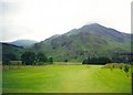
The chapel is in a superb location, with Loch Earn to the east, the River Earn just to the north and Fillan's Hill with Dundurn hillfort to the east-south-east.
The chapel can be reached by driving down a small track leading to St Fillans Golf Club, to the east of Loch Earn, but following the track further down towards Wester Dundurn Farm. Just before the driveway to the farm, there is a gated track leading east to the chapel.
You may be viewing yesterday's version of this page. To see the most up to date information please register for a free account.
 (PID:244834)")
 (PID:244833)")
 (PID:172448)")
Do not use the above information on other web sites or publications without permission of the contributor.
Nearby Images from Geograph Britain and Ireland:
©2015(licence)
©2015(licence)
©2015(licence)
©2007(licence)
©2005(licence)
The above images may not be of the site on this page, they are loaded from Geograph.
Please Submit an Image of this site or go out and take one for us!
Click here to see more info for this site
Nearby sites
Key: Red: member's photo, Blue: 3rd party photo, Yellow: other image, Green: no photo - please go there and take one, Grey: site destroyed
Download sites to:
KML (Google Earth)
GPX (GPS waypoints)
CSV (Garmin/Navman)
CSV (Excel)
To unlock full downloads you need to sign up as a Contributory Member. Otherwise downloads are limited to 50 sites.
Turn off the page maps and other distractions
Nearby sites listing. In the following links * = Image available
518m SE 125° St Fillan's Well (Comrie) Holy Well or Sacred Spring (NN70802327)
538m SE 126° St Fillan's Chair (Dundurn) Natural Stone / Erratic / Other Natural Feature (NN70812325)
572m N 354° Little Port* Standing Stone (Menhir) (NN70342415)
1.9km E 100° Kindrochat Chambered Cairn (NN722232)
2.0km ESE 105° Loch Earn Chambered Cairn (NN723230)
3.7km E 97° Cluan-Glasdale Stone Circle (NN7423)
5.2km E 101° Tullybannocher* Stone Circle (NN75482247)
6.3km ESE 109° Craggish (Comrie) Standing Stones (NN763214)
6.5km ESE 110° Comrie Cursus Cursus (NN76422112)
6.6km ESE 114° Craggish Stone Row / Alignment (NN763207)
6.8km ESE 102° Tom na Chessaig Stone Circle (NN770220)
7.2km E 98° Coney Hill (Comrie)* Misc. Earthwork (NN77552238)
7.5km ESE 113° Comrie Cursus Cursus (NN77252048)
7.6km ESE 111° West Cowden* Stone Row / Alignment (NN7744520645)
7.7km ESE 112° Comrie Cursus Cursus (NN77422047)
8.0km ESE 105° Dalginross* Stone Circle (NN7802521264)
8.1km ENE 77° Balmuick* Stone Circle (NN78362513)
9.2km ESE 114° Auchingarrich Farm Standing Stone (Menhir) (NN78731958)
9.7km E 94° Lawers* Standing Stone (Menhir) (NN80102267)
10.0km SE 125° Giant's Knowe (Culloch) Cairn (NN78481762)
10.5km ESE 121° Craigneich Farm* Standing Stone (Menhir) (NN7922617871)
10.8km E 91° Clathick House Standing Stone (Menhir) (NN81212315)
10.8km SE 125° Dunruchan C (Muthill)* Standing Stone (Menhir) (NN7910817137)
10.9km SE 126° Dunruchan D (Muthill)* Standing Stone (Menhir) (NN7904416881)
10.9km SE 126° Dunruchan E (Muthill)* Standing Stone (Menhir) (NN7899716819)
View more nearby sites and additional images


 We would like to know more about this location. Please feel free to add a brief description and any relevant information in your own language.
 Wir möchten mehr über diese Stätte erfahren. Bitte zögern Sie nicht, eine kurze Beschreibung und relevante Informationen in Deutsch hinzuzufügen.
 Nous aimerions en savoir encore un peu sur les lieux. S'il vous plaît n'hesitez pas à ajouter une courte description et tous les renseignements pertinents dans votre propre langue.
 Quisieramos informarnos un poco más de las lugares. No dude en añadir una breve descripción y otros datos relevantes en su propio idioma.