<< Our Photo Pages >> Cefn Wyfre - Stone Circle in Wales in Powys
Submitted by Cerrig on Monday, 01 February 2010 Page Views: 6272
Neolithic and Bronze AgeSite Name: Cefn WyfreCountry: Wales
NOTE: This site is 2.594 km away from the location you searched for.
County: Powys Type: Stone Circle
Nearest Town: Builth Wells Nearest Village: Painscastle
Map Ref: SO14005105
Latitude: 52.151011N Longitude: 3.258359W
Condition:
| 5 | Perfect |
| 4 | Almost Perfect |
| 3 | Reasonable but with some damage |
| 2 | Ruined but still recognisable as an ancient site |
| 1 | Pretty much destroyed, possibly visible as crop marks |
| 0 | No data. |
| -1 | Completely destroyed |
| 5 | Superb |
| 4 | Good |
| 3 | Ordinary |
| 2 | Not Good |
| 1 | Awful |
| 0 | No data. |
| 5 | Can be driven to, probably with disabled access |
| 4 | Short walk on a footpath |
| 3 | Requiring a bit more of a walk |
| 2 | A long walk |
| 1 | In the middle of nowhere, a nightmare to find |
| 0 | No data. |
| 5 | co-ordinates taken by GPS or official recorded co-ordinates |
| 4 | co-ordinates scaled from a detailed map |
| 3 | co-ordinates scaled from a bad map |
| 2 | co-ordinates of the nearest village |
| 1 | co-ordinates of the nearest town |
| 0 | no data |
Internal Links:
External Links:
I have visited· I would like to visit
grandmasterglitch would like to visit
cerrig has visited here
")
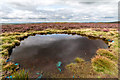
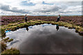
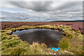
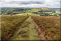
There are some bare areas where the heather has been burned in order to regenerate as fresh growth,which would account for the unnaturally short and uniform heather. This makes for easier walking than you normally get in a wild moor,but it has completely covered the circle and mound. Both were fairly invisible until I was right on top of them. The only real clue to their whereabouts being the largeish conglomerate boulder sticking out of the undergrowth. This was the only stone I could find, the others were unfindable. The mound can be just about discerned by it's circular ditch, and slightly raised central area.
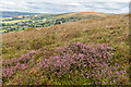
All in all a curious site, a bit of an anomoly for the locality. Not at all impressive in itself, but as is the norm for the welsh hills, the views are panoramic, and hills 80 miles to the north can be seen on a good day.
Not an easy place to get to, with very steep climbs in every direction, and a gps makes finding it easier. Although it is only 100 meters from a good path, with a small pond marking the departure point, you have to be within 50 meters to see the boulder in the circle.
As the moor is managed for the grouse, it can only be a matter of time before the heather that covers the circle is burned off, but when is anybodies guess, until then theres not much to see, except the whole of Powys and even a bit of England to the East, if you like that sort of thing.
The site is intervisible with Banc y Cellin stone circle to the West, several miles away on the skyline.
An enthusiasts circle.
You may be viewing yesterday's version of this page. To see the most up to date information please register for a free account.
")
")
")
Do not use the above information on other web sites or publications without permission of the contributor.
Nearby Images from Geograph Britain and Ireland:
©2015(licence)
©2015(licence)
©2015(licence)
©2015(licence)
©2015(licence)
The above images may not be of the site on this page, they are loaded from Geograph.
Please Submit an Image of this site or go out and take one for us!
Click here to see more info for this site
Nearby sites
Key: Red: member's photo, Blue: 3rd party photo, Yellow: other image, Green: no photo - please go there and take one, Grey: site destroyed
Download sites to:
KML (Google Earth)
GPX (GPS waypoints)
CSV (Garmin/Navman)
CSV (Excel)
To unlock full downloads you need to sign up as a Contributory Member. Otherwise downloads are limited to 50 sites.
Turn off the page maps and other distractions
Nearby sites listing. In the following links * = Image available
2.4km ENE 76° Six Stones* Stone Circle (SO163516)
3.4km N 1° Giant's Grave (Powys)* Round Barrow(s) (SO141544)
3.4km NE 40° Wern Hill Camp* Hillfort (SO162536)
5.9km NE 39° Cwmceste Barrow* Round Barrow(s) (SO1775655582)
5.9km WNW 300° Bryntwppa* Stone Row / Alignment (SO08905410)
6.0km NW 309° Perthi Common Cairns 1, 2, 3, 4* Cairn (SO0940654856)
6.0km NNE 15° Pedwar Maen* Stone Row / Alignment (SO156568)
6.0km NNE 15° Bryn-Y-Maen Barrow Round Barrow(s) (SO15665686)
6.2km WSW 256° Aberedw Hill Barrows* Barrow Cemetery (SO07914964)
6.3km WSW 252° Cefnhinog Standing Stone* Standing Stone (Menhir) (SO07944925)
6.5km NW 323° Cwm Stone* Standing Stone (Menhir) (SO10185630)
6.6km WNW 304° The Gaer* Hillfort (SO08555480)
6.7km WNW 299° Cilberllan Ring Cairn* Cairn (SO0815654436)
6.8km NNE 22° Bryn-y-Maen* Standing Stone (Menhir) (SO16685728)
6.8km NE 40° Gilwern Brook Barrows* Round Barrow(s) (SO18515618)
6.9km N 2° Rhos-Maen* Stone Circle (SO143579)
6.9km SW 235° Aberedw Spring* Holy Well or Sacred Spring (SO0825547249)
7.2km WNW 296° Cwm-Berwyn Round Cairn* Cairn (SO076543)
7.2km NW 322° Gwernfach Cairns I,II,III & IV* Cairn (SO096568)
7.3km NW 313° Castle Bank (Radnorshire)* Hillfort (SO08695608)
7.4km N 352° Graig Camp* Hillfort (SO131584)
7.7km WNW 298° Cwmberwyn Camp* Hillfort (SO07275481)
7.7km NNE 12° Llanerch Stone* Rock Art (SO15765858)
7.7km N 0° Cwm Maerdy* Standing Stone (Menhir) (SO14205879)
7.8km NW 318° Court Stone Row* Stone Row / Alignment (SO08865695)
View more nearby sites and additional images


 We would like to know more about this location. Please feel free to add a brief description and any relevant information in your own language.
 Wir möchten mehr über diese Stätte erfahren. Bitte zögern Sie nicht, eine kurze Beschreibung und relevante Informationen in Deutsch hinzuzufügen.
 Nous aimerions en savoir encore un peu sur les lieux. S'il vous plaît n'hesitez pas à ajouter une courte description et tous les renseignements pertinents dans votre propre langue.
 Quisieramos informarnos un poco más de las lugares. No dude en añadir una breve descripción y otros datos relevantes en su propio idioma.