 with our Megalithic Portal iPhone app")
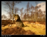

<< Our Photo Pages >> Broughdearg - Stone Circle in Scotland in Perth and Kinross
Submitted by Nick on Tuesday, 12 November 2002 Page Views: 8485
Neolithic and Bronze AgeSite Name: BroughdeargCountry: Scotland
NOTE: This site is 0.852 km away from the location you searched for.
County: Perth and Kinross Type: Stone Circle
Map Ref: NO1374567047 Landranger Map Number: 43
Latitude: 56.786957N Longitude: 3.41346W
Condition:
| 5 | Perfect |
| 4 | Almost Perfect |
| 3 | Reasonable but with some damage |
| 2 | Ruined but still recognisable as an ancient site |
| 1 | Pretty much destroyed, possibly visible as crop marks |
| 0 | No data. |
| -1 | Completely destroyed |
| 5 | Superb |
| 4 | Good |
| 3 | Ordinary |
| 2 | Not Good |
| 1 | Awful |
| 0 | No data. |
| 5 | Can be driven to, probably with disabled access |
| 4 | Short walk on a footpath |
| 3 | Requiring a bit more of a walk |
| 2 | A long walk |
| 1 | In the middle of nowhere, a nightmare to find |
| 0 | No data. |
| 5 | co-ordinates taken by GPS or official recorded co-ordinates |
| 4 | co-ordinates scaled from a detailed map |
| 3 | co-ordinates scaled from a bad map |
| 2 | co-ordinates of the nearest village |
| 1 | co-ordinates of the nearest town |
| 0 | no data |
Internal Links:
External Links:
I have visited· I would like to visit
hamish Klingon have visited here
")
These stones stand beside a farm building, acting like gateposts for a field entrance. No significant markings on either of them. The farm road to Dunmay branches east from the A93 a couple of miles south of Spittal of Glenshee, crossing a small bridge. Cars with dodgy suspensions should avoid this road like the plague, as it's suitable only for tractors or 4X4's only! The road bends to the right about 200m in, and park here at the wide space to ensure farm vehicles are not impeded. The stones are up on a low mound, above what appears to have been an old kiln. The farmer has no problem with people viewing them.
You may be viewing yesterday's version of this page. To see the most up to date information please register for a free account.
")
")
")
")
")
")
")
")
")
")
Do not use the above information on other web sites or publications without permission of the contributor.
Click here to see more info for this site
Nearby sites
Key: Red: member's photo, Blue: 3rd party photo, Yellow: other image, Green: no photo - please go there and take one, Grey: site destroyed
Download sites to:
KML (Google Earth)
GPX (GPS waypoints)
CSV (Garmin/Navman)
CSV (Excel)
To unlock full downloads you need to sign up as a Contributory Member. Otherwise downloads are limited to 50 sites.
Turn off the page maps and other distractions
Nearby sites listing. In the following links * = Image available
3.7km NW 325° Grave of Diarmid* Stone Circle (NO117701)
4.1km NW 316° Spittal of Glenshee Modern Stone Circle* Modern Stone Circle etc (NO10927004)
4.3km NW 316° Spittal of Glenshee Standing Stone* Standing Stone (Menhir) (NO1086770194)
4.9km SSW 196° Glenkilrie Stone Circle (NO123624)
6.3km N 350° Cleann Beag Cairn* Cairn (NO12737327)
6.3km W 261° Faire na Paitig* Stone Circle (NO07456620)
6.3km NNW 344° Gleann Beag Stone Circle (NO12127318)
6.6km SSE 165° The Borland Stone* Standing Stone (Menhir) (NO1536160677)
7.0km WSW 246° Slimestone* Standing Stone (Menhir) (NO0722364367)
8.6km WSW 239° Giant's Grave, Enochdhu* Standing Stone (Menhir) (NO06296279)
8.7km WSW 241° Enochdhu* Standing Stone (Menhir) (NO060630)
8.9km WSW 244° Croft House Stone* Standing Stone (Menhir) (NO057633)
9.0km WSW 243° Kindrogan Standing Stones (NO056632)
9.1km SW 217° Kirkmichael Stone Circle (NO08085985)
9.6km WSW 252° Witch's Stone, Straloch Standing Stone (Menhir) (NO04516431)
10.5km WSW 250° Straloch* Standing Stone (Menhir) (NO038637)
11.2km SSW 203° Balnabroich* Standing Stones (NO0917556752)
13.0km SSE 157° Drumderg 1 (Tullymurdoch) Rock Art (NO18525497)
13.3km SSW 213° Pitcarmick Burn Standing Stone (Menhir) (NO06165610)
14.4km SSE 166° Rannagulzion Standing Stone (Menhir) (NO1753)
15.2km SSE 155° Alyth Burn Hut Circles Ancient Village or Settlement (NO199531)
15.3km S 186° Cally Standing Stones (NO118519)
16.4km SE 139° Kilry* Standing Stone (Menhir) (NO24325449)
16.6km SSE 159° Parkneuk* Stone Circle (NO195515)
16.6km SSE 159° Tullymurdoch* Stone Circle (NO194514)
View more nearby sites and additional images


 We would like to know more about this location. Please feel free to add a brief description and any relevant information in your own language.
 Wir möchten mehr über diese Stätte erfahren. Bitte zögern Sie nicht, eine kurze Beschreibung und relevante Informationen in Deutsch hinzuzufügen.
 Nous aimerions en savoir encore un peu sur les lieux. S'il vous plaît n'hesitez pas à ajouter une courte description et tous les renseignements pertinents dans votre propre langue.
 Quisieramos informarnos un poco más de las lugares. No dude en añadir una breve descripción y otros datos relevantes en su propio idioma.