<< Text Pages >> Red Rocks - Ancient Mine, Quarry or other Industry in England in Merseyside
Submitted by thedrumdoctor on Tuesday, 05 April 2011 Page Views: 5672
Multi-periodSite Name: Red Rocks Alternative Name: Hilbre PointCountry: England
NOTE: This site is 1.155 km away from the location you searched for.
County: Merseyside Type: Ancient Mine, Quarry or other Industry
Nearest Town: Hoylake
Map Ref: SJ20328843
Latitude: 53.386677N Longitude: 3.199483W
Condition:
| 5 | Perfect |
| 4 | Almost Perfect |
| 3 | Reasonable but with some damage |
| 2 | Ruined but still recognisable as an ancient site |
| 1 | Pretty much destroyed, possibly visible as crop marks |
| 0 | No data. |
| -1 | Completely destroyed |
| 5 | Superb |
| 4 | Good |
| 3 | Ordinary |
| 2 | Not Good |
| 1 | Awful |
| 0 | No data. |
| 5 | Can be driven to, probably with disabled access |
| 4 | Short walk on a footpath |
| 3 | Requiring a bit more of a walk |
| 2 | A long walk |
| 1 | In the middle of nowhere, a nightmare to find |
| 0 | No data. |
| 5 | co-ordinates taken by GPS or official recorded co-ordinates |
| 4 | co-ordinates scaled from a detailed map |
| 3 | co-ordinates scaled from a bad map |
| 2 | co-ordinates of the nearest village |
| 1 | co-ordinates of the nearest town |
| 0 | no data |
Be the first person to rate this site - see the 'Contribute!' box in the right hand menu.
Internal Links:
External Links:
Ancient Mine, Quarry or other Industry in Merseyside
Mesolithic to Early Bronze age flint working site
[SJ 20248853](2) Neolithic floor discovered at Hilbre
Point in 1914, when about 100 flints, associated with animal
remains and shell-fish, came to light resting on the thin layer
of clay (in many places blackened by fire) which underlies the sand.
The finds include lance-heads, a barbed arrowhead, round scrapers,
knives and borers. All are of Antrim flint.
The site can be compared to that at Red Noses New Brighton
[SJ 29 SE 1 - which extends from the Mesolithic to E. Bronze Age].
(1,2)
Hilbre Point is centred at SJ 20328843.
There is no trace of antiquity and the exact site of the chipping
floor could not be ascertained. (3)
SOURCE TEXT
( 1) General reference
Trans. Lancs. & Ches. A.S. 32, 1914. 245-6. (T.A. Glenn)
( 2) General reference
Corr. 6" (G. Webster 1949)
( 3) Field Investigators Comments
F1 TPW 26-AUG-64
Submitters Comments
This grid reference shows the site to be within the grounds of a private dwelling, currently a nursing home at the time of writing.
It is likely that the site was undeveloped in 1914 as a map of 1910 shows no buildings there. To quote from 'Prehistoric Cheshire' (Victoria & Paul Morgan, 2004):
"A number of Early Mesolithic tools have been found near New Brighton and at Red Rocks in Hoylake in what was then a flat, wooded landscape. These areas would have been attractive with well-drained soils and strategic views to the north, an area now under Liverpool Bay."
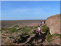
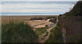
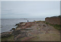
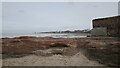
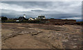
Today the surrounding area is a tidal beach with sandstone outcrops and sand dunes.
You may be viewing yesterday's version of this page. To see the most up to date information please register for a free account.
Do not use the above information on other web sites or publications without permission of the contributor.
Nearby Images from Geograph Britain and Ireland:
©2009(licence)
©2017(licence)
©2024(licence)
©2024(licence)
©2017(licence)
The above images may not be of the site on this page, they are loaded from Geograph.
Please Submit an Image of this site or go out and take one for us!
Click here to see more info for this site
Nearby sites
Key: Red: member's photo, Blue: 3rd party photo, Yellow: other image, Green: no photo - please go there and take one, Grey: site destroyed
Download sites to:
KML (Google Earth)
GPX (GPS waypoints)
CSV (Garmin/Navman)
CSV (Excel)
To unlock full downloads you need to sign up as a Contributory Member. Otherwise downloads are limited to 50 sites.
Turn off the page maps and other distractions
Nearby sites listing. In the following links * = Image available
1.9km WSW 253° Hilbre Island (Wirral Peninsula) Ancient Cross (SJ185879)
2.5km SE 131° West Kirby Cremation Burial Cist (SJ22158678)
2.5km SE 143° St Bridget (West Kirby)* Early Christian Sculptured Stone (SJ21828641)
2.6km SE 133° The Column* Chambered Tomb (SJ222866)
3.5km NE 51° Great Meols* Ancient Village or Settlement (SJ231906)
4.1km SE 137° Face Stone (Stapledon Wood)* Rock Outcrop (SJ23088536)
5.4km SE 129° Thor's Stone* Natural Stone / Erratic / Other Natural Feature (SJ2447484933)
5.7km ESE 107° Greasby Copse Ancient Village or Settlement (SJ25788664)
6.1km E 86° Overchurch* Stone Circle (SJ264888)
7.1km ESE 109° Arrowe Park standing stones Standing Stones (SJ27058596)
8.6km ENE 79° Bidston Hill Rock Carvings* Carving (SJ288900)
10.0km E 85° The Bonks Barrow Cemetery (SJ303891)
11.3km SSW 197° Ffynnon Oswald Holy Well or Sacred Spring (SJ1688577622)
11.7km SSW 208° Whitford Church Inscribed Stone Early Christian Sculptured Stone (SJ146782)
11.8km SSW 208° Whitford Inscribed Stone* Early Christian Sculptured Stone (SJ146781)
12.1km SW 217° Maen Achwyfan* Ancient Cross (SJ129788)
12.3km S 187° St Winefrides Well* Holy Well or Sacred Spring (SJ18517627)
12.8km SW 230° Axton Barrows Round Barrow(s) (SJ104803)
12.9km SSW 202° Gorsedd Church* Standing Stones (SJ152766)
13.0km SSW 204° Y Gorseddau* Round Barrow(s) (SJ149766)
13.4km SW 232° Bryn-Y-Odyn* Round Barrow(s) (SJ0952380376)
13.6km SSW 194° Naid-Y-March* Standing Stones (SJ1676775288)
13.6km SSW 194° Naid-y-March* Standing Stones (SJ16767528)
14.0km SE 140° St Mary and St Helen (Neston)* Ancient Cross (SJ29157749)
14.1km SW 233° Gop Wood Mound* Cairn (SJ08928012)
View more nearby sites and additional images


 We would like to know more about this location. Please feel free to add a brief description and any relevant information in your own language.
 Wir möchten mehr über diese Stätte erfahren. Bitte zögern Sie nicht, eine kurze Beschreibung und relevante Informationen in Deutsch hinzuzufügen.
 Nous aimerions en savoir encore un peu sur les lieux. S'il vous plaît n'hesitez pas à ajouter une courte description et tous les renseignements pertinents dans votre propre langue.
 Quisieramos informarnos un poco más de las lugares. No dude en añadir una breve descripción y otros datos relevantes en su propio idioma.