<< Our Photo Pages >> Formby Point - Ancient Trackway in England in Lancashire
Submitted by Klingon on Thursday, 06 October 2016 Page Views: 21011
Mesolithic, Palaeolithic and EarlierSite Name: Formby PointCountry: England
NOTE: This site is 10.202 km away from the location you searched for.
County: Lancashire Type: Ancient Trackway
Nearest Town: Formby
Map Ref: SD27500800
Latitude: 53.563585N Longitude: 3.096076W
Condition:
| 5 | Perfect |
| 4 | Almost Perfect |
| 3 | Reasonable but with some damage |
| 2 | Ruined but still recognisable as an ancient site |
| 1 | Pretty much destroyed, possibly visible as crop marks |
| 0 | No data. |
| -1 | Completely destroyed |
| 5 | Superb |
| 4 | Good |
| 3 | Ordinary |
| 2 | Not Good |
| 1 | Awful |
| 0 | No data. |
| 5 | Can be driven to, probably with disabled access |
| 4 | Short walk on a footpath |
| 3 | Requiring a bit more of a walk |
| 2 | A long walk |
| 1 | In the middle of nowhere, a nightmare to find |
| 0 | No data. |
| 5 | co-ordinates taken by GPS or official recorded co-ordinates |
| 4 | co-ordinates scaled from a detailed map |
| 3 | co-ordinates scaled from a bad map |
| 2 | co-ordinates of the nearest village |
| 1 | co-ordinates of the nearest town |
| 0 | no data |
Internal Links:
External Links:
I have visited· I would like to visit
AmyBlahBlahBlah would like to visit
")
More at our article Prehistoric Footprints Under the Sand and the Formby Footprints web site by Gordon Roberts.
Note: Sad to hear of the death of Gordon Roberts, prehistoric footprints researcher. Here's a reminder of his discoveries.
You may be viewing yesterday's version of this page. To see the most up to date information please register for a free account.
")
")
")
Do not use the above information on other web sites or publications without permission of the contributor.
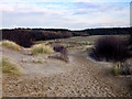
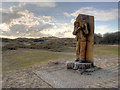
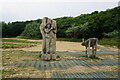
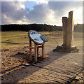
Nearby Images from Geograph Britain and Ireland:
©2016(licence)
©2016(licence)

©2016(licence)
©2023(licence)
©2016(licence)
The above images may not be of the site on this page, they are loaded from Geograph.
Please Submit an Image of this site or go out and take one for us!
Click here to see more info for this site
Nearby sites
Key: Red: member's photo, Blue: 3rd party photo, Yellow: other image, Green: no photo - please go there and take one, Grey: site destroyed
Download sites to:
KML (Google Earth)
GPX (GPS waypoints)
CSV (Garmin/Navman)
CSV (Excel)
To unlock full downloads you need to sign up as a Contributory Member. Otherwise downloads are limited to 50 sites.
Turn off the page maps and other distractions
Nearby sites listing. In the following links * = Image available
1.4km SSE 156° The Godstone* Marker Stone (SD28070668)
9.1km SE 125° Lunt Meadows* Ancient Village or Settlement (SD349027)
10.4km SE 129° St Helen's Well (Sefton) Holy Well or Sacred Spring (SD35450129)
13.8km E 87° Church of Saint Peter and Saint Paul* Carving (SD4130608436)
15.6km SSE 147° St Mary (Walton on the Hill) Ancient Cross (SJ35889482)
16.6km SE 145° Modern stone circle on Cherry Avenue* Modern Stone Circle etc (SJ3687894265)
17.9km SSW 193° Great Meols* Ancient Village or Settlement (SJ231906)
18.0km S 175° Bidston Hill Rock Carvings* Carving (SJ288900)
18.7km SSE 156° World Museum Liverpool* Museum (SJ348908)
19.1km S 171° The Bonks Barrow Cemetery (SJ303891)
19.2km S 182° Overchurch* Stone Circle (SJ264888)
20.8km SSW 199° Red Rocks Ancient Mine, Quarry or other Industry (SJ20328843)
21.4km S 184° Greasby Copse Ancient Village or Settlement (SJ25788664)
21.8km SSE 147° Monk's Well (Wavertree)* Holy Well or Sacred Spring (SJ39288959)
21.9km SSW 193° West Kirby Cremation Burial Cist (SJ22158678)
22.0km SSW 203° Hilbre Island (Wirral Peninsula) Ancient Cross (SJ185879)
22.0km SSW 193° The Column* Chambered Tomb (SJ222866)
22.0km S 180° Arrowe Park standing stones Standing Stones (SJ27058596)
22.3km SSW 194° St Bridget (West Kirby)* Early Christian Sculptured Stone (SJ21828641)
23.1km S 190° Face Stone (Stapledon Wood)* Rock Outcrop (SJ23088536)
23.3km S 187° Thor's Stone* Natural Stone / Erratic / Other Natural Feature (SJ2447484933)
24.1km SSE 147° The Calderstones* Chambered Tomb (SJ4040287622)
24.4km N 8° Fairy Well (Stonyhill) Holy Well or Sacred Spring (SD31133210)
24.4km SSE 151° Solomon's Tomb Modern Stone Circle etc (SJ391865)
24.4km E 82° Boar's Den* Round Barrow(s) (SD51771116)
View more nearby sites and additional images


 We would like to know more about this location. Please feel free to add a brief description and any relevant information in your own language.
 Wir möchten mehr über diese Stätte erfahren. Bitte zögern Sie nicht, eine kurze Beschreibung und relevante Informationen in Deutsch hinzuzufügen.
 Nous aimerions en savoir encore un peu sur les lieux. S'il vous plaît n'hesitez pas à ajouter une courte description et tous les renseignements pertinents dans votre propre langue.
 Quisieramos informarnos un poco más de las lugares. No dude en añadir una breve descripción y otros datos relevantes en su propio idioma.