<< Our Photo Pages >> Monk's Well (Wavertree) - Holy Well or Sacred Spring in England in Merseyside
Submitted by HOLYWELL on Wednesday, 26 March 2008 Page Views: 16469
Springs and Holy WellsSite Name: Monk's Well (Wavertree)Country: England
NOTE: This site is 2.042 km away from the location you searched for.
County: Merseyside Type: Holy Well or Sacred Spring
Nearest Town: Liverpool Nearest Village: Wavertree Village
Map Ref: SJ39288959
Latitude: 53.399626N Longitude: 2.914682W
Condition:
| 5 | Perfect |
| 4 | Almost Perfect |
| 3 | Reasonable but with some damage |
| 2 | Ruined but still recognisable as an ancient site |
| 1 | Pretty much destroyed, possibly visible as crop marks |
| 0 | No data. |
| -1 | Completely destroyed |
| 5 | Superb |
| 4 | Good |
| 3 | Ordinary |
| 2 | Not Good |
| 1 | Awful |
| 0 | No data. |
| 5 | Can be driven to, probably with disabled access |
| 4 | Short walk on a footpath |
| 3 | Requiring a bit more of a walk |
| 2 | A long walk |
| 1 | In the middle of nowhere, a nightmare to find |
| 0 | No data. |
| 5 | co-ordinates taken by GPS or official recorded co-ordinates |
| 4 | co-ordinates scaled from a detailed map |
| 3 | co-ordinates scaled from a bad map |
| 2 | co-ordinates of the nearest village |
| 1 | co-ordinates of the nearest town |
| 0 | no data |
Internal Links:
External Links:
 (PID:37596)")
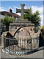
The well head appears dry and has been tastefully coverted in a flower bed ( which probably hides the original steps down to the water ). The tap head is worn but remarkably the 15th century inscription appears to survive.
It states: Qui non dat quod habet, Dæmon infra vide 1414. The inscription roughly reading 'He who here does nought bestow, The Devil laughs at him below". This based on the belief that travellers should give alms on drinking. If they omitted to do so, a devil who was chained at the bottom laughed. The cross which was lost when antiquarianHope described it in 1895 was restored the last century and bears the inscription 'Deus dedit, homo bibit'. God gives and man drinks. A monastic building stood near and the occupants received the contributions. The well is also said to be a pin well and a secret tunnel lead from it. The nearby area is called significantly Childwall. ( cold well? ). The site was officially protected in 1952.
You may be viewing yesterday's version of this page. To see the most up to date information please register for a free account.
 (PID:37593)")
 (PID:37595)")
 (PID:37592)")
Do not use the above information on other web sites or publications without permission of the contributor.
Nearby Images from Geograph Britain and Ireland:
©2021(licence)
©2009(licence)
©2009(licence)
©2009(licence)
©2009(licence)
The above images may not be of the site on this page, they are loaded from Geograph.
Please Submit an Image of this site or go out and take one for us!
Click here to see more info for this site
Nearby sites
Key: Red: member's photo, Blue: 3rd party photo, Yellow: other image, Green: no photo - please go there and take one, Grey: site destroyed
Download sites to:
KML (Google Earth)
GPX (GPS waypoints)
CSV (Garmin/Navman)
CSV (Excel)
To unlock full downloads you need to sign up as a Contributory Member. Otherwise downloads are limited to 50 sites.
Turn off the page maps and other distractions
Nearby sites listing. In the following links * = Image available
2.3km SSE 150° The Calderstones* Chambered Tomb (SJ4040287622)
3.1km S 183° Solomon's Tomb Modern Stone Circle etc (SJ391865)
3.3km SSE 167° Robin Hood's Stone* Standing Stone (Menhir) (SJ3997886383)
4.6km WNW 284° World Museum Liverpool* Museum (SJ348908)
4.9km SE 140° Camp Hill (Woolton) Hillfort (SJ424858)
5.3km NNW 332° Modern stone circle on Cherry Avenue* Modern Stone Circle etc (SJ3687894265)
6.2km NNW 326° St Mary (Walton on the Hill) Ancient Cross (SJ35889482)
8.2km SW 215° St Patrick's Well (Bromborough)* Holy Well or Sacred Spring (SJ34538295)
8.6km SSW 210° St Barnabas (Bromborough)* Ancient Cross (SJ3491082212)
9.0km W 266° The Bonks Barrow Cemetery (SJ303891)
10.5km W 272° Bidston Hill Rock Carvings* Carving (SJ288900)
10.8km E 79° St Anne's Well (St Helens)* Holy Well or Sacred Spring (SJ49969143)
12.3km NNW 341° St Helen's Well (Sefton) Holy Well or Sacred Spring (SD35450129)
12.5km E 98° St Luke's Church (Farnworth) Ancient Cross (SJ5171287749)
12.7km SSW 212° Raby Mound Round Barrow(s) (SJ32377891)
12.7km WSW 253° Arrowe Park standing stones Standing Stones (SJ27058596)
12.9km W 266° Overchurch* Stone Circle (SJ264888)
13.8km WSW 257° Greasby Copse Ancient Village or Settlement (SJ25788664)
13.8km NNW 341° Lunt Meadows* Ancient Village or Settlement (SD349027)
15.5km WSW 252° Thor's Stone* Natural Stone / Erratic / Other Natural Feature (SJ2447484933)
15.8km SW 219° St Mary and St Helen (Neston)* Ancient Cross (SJ29157749)
15.8km SSE 161° St Mary (Thornton Le Moors)* Ancient Cross (SJ44157455)
16.2km W 273° Great Meols* Ancient Village or Settlement (SJ231906)
16.7km WSW 255° Face Stone (Stapledon Wood)* Rock Outcrop (SJ23088536)
17.3km ENE 70° Windmill Hill (Earlestown)* Round Barrow(s) (SJ55639531)
View more nearby sites and additional images


 We would like to know more about this location. Please feel free to add a brief description and any relevant information in your own language.
 Wir möchten mehr über diese Stätte erfahren. Bitte zögern Sie nicht, eine kurze Beschreibung und relevante Informationen in Deutsch hinzuzufügen.
 Nous aimerions en savoir encore un peu sur les lieux. S'il vous plaît n'hesitez pas à ajouter une courte description et tous les renseignements pertinents dans votre propre langue.
 Quisieramos informarnos un poco más de las lugares. No dude en añadir una breve descripción y otros datos relevantes en su propio idioma.