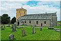
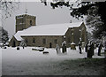
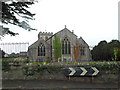
<< Text Pages >> St James's Church (Burton-in-Kendal) - Ancient Cross in England in Cumbria
Submitted by Anne T on Monday, 08 January 2018 Page Views: 902
Early Medieval (Dark Age)Site Name: St James''s Church (Burton-in-Kendal)Country: England
NOTE: This site is 0.847 km away from the location you searched for.
County: Cumbria Type: Ancient Cross
Nearest Town: Burton-in-Kendal
Map Ref: SD5305076921
Latitude: 54.185900N Longitude: 2.720944W
Condition:
| 5 | Perfect |
| 4 | Almost Perfect |
| 3 | Reasonable but with some damage |
| 2 | Ruined but still recognisable as an ancient site |
| 1 | Pretty much destroyed, possibly visible as crop marks |
| 0 | No data. |
| -1 | Completely destroyed |
| 5 | Superb |
| 4 | Good |
| 3 | Ordinary |
| 2 | Not Good |
| 1 | Awful |
| 0 | No data. |
| 5 | Can be driven to, probably with disabled access |
| 4 | Short walk on a footpath |
| 3 | Requiring a bit more of a walk |
| 2 | A long walk |
| 1 | In the middle of nowhere, a nightmare to find |
| 0 | No data. |
| 5 | co-ordinates taken by GPS or official recorded co-ordinates |
| 4 | co-ordinates scaled from a detailed map |
| 3 | co-ordinates scaled from a bad map |
| 2 | co-ordinates of the nearest village |
| 1 | co-ordinates of the nearest town |
| 0 | no data |
Be the first person to rate this site - see the 'Contribute!' box in the right hand menu.
Internal Links:
External Links:
Ancient Cross in Cumbria
The Northern Antiquarian (TNA) features a page for these ancient cross fragments - see their entry for St. James Church, Burton-in-Kendal, Cumbria which includes a drawing of the cross fragments and descriptions taken from 19th and 20th century sources.
The Royal Commission dates the cross shafts as probably late 10th century.
The church itself is recorded as Pastscape Monument No. 43014 which simply says the church contains a fragment of early medieval cross shaft.
Note: Have you visited this site? Do you have any photographs, information or illustrations to add?
You may be viewing yesterday's version of this page. To see the most up to date information please register for a free account.
Do not use the above information on other web sites or publications without permission of the contributor.
Nearby Images from Geograph Britain and Ireland:

©2016(licence)
©2022(licence)
©2009(licence)
©2012(licence)

©2009(licence)
The above images may not be of the site on this page, they are loaded from Geograph.
Please Submit an Image of this site or go out and take one for us!
Click here to see more info for this site
Nearby sites
Key: Red: member's photo, Blue: 3rd party photo, Yellow: other image, Green: no photo - please go there and take one, Grey: site destroyed
Download sites to:
KML (Google Earth)
GPX (GPS waypoints)
CSV (Garmin/Navman)
CSV (Excel)
To unlock full downloads you need to sign up as a Contributory Member. Otherwise downloads are limited to 50 sites.
Turn off the page maps and other distractions
Nearby sites listing. In the following links * = Image available
2.4km SW 227° Yealand ancient stone walls or rows 2 Misc. Earthwork (SD513753)
2.8km SW 215° Yealand ancient stone walls or rows 1 Misc. Earthwork (SD514746)
3.3km NNE 23° Holme Park Fell 2* Rock Outcrop (SD5439879957)
3.4km NNE 19° Holme Park Fell 1* Rock Outcrop (SD5419280141)
3.9km SW 227° Summerhouse Hill Cairn* Cairn (SD50147428)
3.9km SW 229° Summerhouse Hill* Modern Stone Circle etc (SD50037437)
4.0km NW 305° The Rent Stone* Natural Stone / Erratic / Other Natural Feature (SD498792)
4.0km ENE 70° Hutton Roof Crag perched Limestone Boulder* Natural Stone / Erratic / Other Natural Feature (SD5686878268)
4.1km S 189° Manor Farm* Round Barrow(s) (SD52387285)
4.7km WNW 296° The Fairy Steps* Natural Stone / Erratic / Other Natural Feature (SD488790)
4.8km NW 311° Bela Stone Row* Stone Row / Alignment (SD495801)
4.9km SW 225° The Three brothers* Natural Stone / Erratic / Other Natural Feature (SD495735)
4.9km SW 219° Warton Crag giant wall Misc. Earthwork (SD499731)
5.1km W 269° Haweswater Cairns and Propped Stone Cairn (SD479769)
5.2km W 270° Haweswater Stones* Misc. Earthwork (SD478770)
5.5km W 267° Bowk Stone Natural Stone / Erratic / Other Natural Feature (SD475767)
5.5km ENE 68° Gallowber Lane Romano-British Settlement/Enclosure* Ancient Village or Settlement (SD5823678908)
5.7km SW 222° Warton Crag* Hillfort (SD492727)
5.8km WNW 303° The Dog Hole Cave or Rock Shelter (SD482801)
5.8km NW 310° Haverbrack Fell Misc. Earthwork (SD486807)
5.9km WNW 302° Dog Hole possible dolmen/propped stone* Natural Stone / Erratic / Other Natural Feature (SD481801)
5.9km WNW 283° Hazelslack Stone* Standing Stone (Menhir) (SD473783)
6.0km WNW 302° Haverbrack Cairn Cairn (SD480802)
6.1km SW 230° Dog Holes* Cave or Rock Shelter (SD48337303)
6.3km SW 229° Badger Hole (Lancashire)* Cave or Rock Shelter (SD48187285)
View more nearby sites and additional images


 We would like to know more about this location. Please feel free to add a brief description and any relevant information in your own language.
 Wir möchten mehr über diese Stätte erfahren. Bitte zögern Sie nicht, eine kurze Beschreibung und relevante Informationen in Deutsch hinzuzufügen.
 Nous aimerions en savoir encore un peu sur les lieux. S'il vous plaît n'hesitez pas à ajouter une courte description et tous les renseignements pertinents dans votre propre langue.
 Quisieramos informarnos un poco más de las lugares. No dude en añadir una breve descripción y otros datos relevantes en su propio idioma.