<< Other Photo Pages >> Roeburndale stone circle - Modern Stone Circle etc in England in Lancashire
Submitted by Pav on Sunday, 15 July 2012 Page Views: 4985
Modern SitesSite Name: Roeburndale stone circleCountry: England
NOTE: This site is 1.448 km away from the location you searched for.
County: Lancashire Type: Modern Stone Circle etc
Nearest Village: Hornby
Map Ref: SD60086496
Latitude: 54.079004N Longitude: 2.611639W
Condition:
| 5 | Perfect |
| 4 | Almost Perfect |
| 3 | Reasonable but with some damage |
| 2 | Ruined but still recognisable as an ancient site |
| 1 | Pretty much destroyed, possibly visible as crop marks |
| 0 | No data. |
| -1 | Completely destroyed |
| 5 | Superb |
| 4 | Good |
| 3 | Ordinary |
| 2 | Not Good |
| 1 | Awful |
| 0 | No data. |
| 5 | Can be driven to, probably with disabled access |
| 4 | Short walk on a footpath |
| 3 | Requiring a bit more of a walk |
| 2 | A long walk |
| 1 | In the middle of nowhere, a nightmare to find |
| 0 | No data. |
| 5 | co-ordinates taken by GPS or official recorded co-ordinates |
| 4 | co-ordinates scaled from a detailed map |
| 3 | co-ordinates scaled from a bad map |
| 2 | co-ordinates of the nearest village |
| 1 | co-ordinates of the nearest town |
| 0 | no data |
Internal Links:
External Links:
Modern Stone Circle in Lancashire
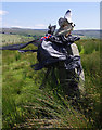
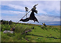
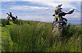
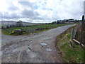
A modern (30, 40 years?) stone circle made out of nine gate posts - most, if not all, stones have square holes in them and some have metal hinges. There is no evidence of earthworks, i.e., no bank or a ditch, so I would guess the site is entirely modern.
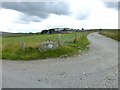
It's a couple of miles south of Hornby village in north Lancashire, can be easily driven to; it's about twenty meters from the road, and there's a gate nearby. At the moment (Jul 2012) it's a part of Witch Way to Pendle trail, hence the witch paraphernalia.
You may be viewing yesterday's version of this page. To see the most up to date information please register for a free account.
Do not use the above information on other web sites or publications without permission of the contributor.
TheCaptain has found this location on Google Street View:
Nearby Images from Geograph Britain and Ireland:
©2012(licence)
©2012(licence)
©2012(licence)
©2018(licence)
©2013(licence)
The above images may not be of the site on this page, they are loaded from Geograph.
Please Submit an Image of this site or go out and take one for us!
Click here to see more info for this site
Nearby sites
Key: Red: member's photo, Blue: 3rd party photo, Yellow: other image, Green: no photo - please go there and take one, Grey: site destroyed
Download sites to:
KML (Google Earth)
GPX (GPS waypoints)
CSV (Garmin/Navman)
CSV (Excel)
To unlock full downloads you need to sign up as a Contributory Member. Otherwise downloads are limited to 50 sites.
Turn off the page maps and other distractions
Nearby sites listing. In the following links * = Image available
3.6km NNE 15° Tatham Enclosure* Ancient Village or Settlement (SD61086846)
4.0km NNW 336° St Margaret (Hornby)* Ancient Cross (SD5847068580)
5.1km NNW 338° Castle Stede Hillfort (SD582697)
5.7km NNW 330° St John the Evangelist (Gressingham)* Ancient Cross (SD5725069915)
6.2km N 357° St Wilfrid (Melling)* Ancient Cross (SD5978571115)
6.3km E 85° Ringstones (Lowgill) Stone Circle (SD664655)
7.0km ENE 79° The Great Stone Of Fourstones* Natural Stone / Erratic / Other Natural Feature (SD6697266292)
7.8km WSW 250° Askew Heights* Ancient Village or Settlement (SD52726239)
9.1km N 8° St John the Baptist (Tunstall)* Early Christian Sculptured Stone (SD6141473925)
9.7km W 269° The Lancaster Cross* Ancient Cross (SD504649)
10.1km W 268° Halton St Wilfrid's Churchyard* Ancient Cross (SD49916469)
11.0km NW 315° Manor Farm* Round Barrow(s) (SD52387285)
11.4km WNW 283° Bolton-le-Sands Barrow* Ring Cairn (SD4901467624)
12.0km WSW 251° Golgotha Lodge (Williamson Park) Cairn (SD48666121)
12.0km WNW 282° Bolton Le Sands Early Christian Sculptured Stone (SD48336765)
12.1km WNW 283° St Michael's Well (Lancashire) Holy Well or Sacred Spring (SD4828567831)
12.4km N 1° Sellet Bank Enclosure* Ancient Village or Settlement (SD60517733)
12.4km WNW 297° Hunting Hill* Round Barrow(s) (SD49037065)
12.8km NNE 22° Leck Hall* Ancient Village or Settlement (SD64927677)
12.8km WSW 255° Lancaster City Museum* Museum (SD4761161729)
13.0km NW 318° Yealand ancient stone walls or rows 1 Misc. Earthwork (SD514746)
13.0km NW 308° Warton Crag giant wall Misc. Earthwork (SD499731)
13.0km WSW 256° Lancaster Priory Cross* Ancient Cross (SD474619)
13.3km NW 305° Warton Crag* Hillfort (SD492727)
13.5km NW 319° Yealand ancient stone walls or rows 2 Misc. Earthwork (SD513753)
View more nearby sites and additional images


 We would like to know more about this location. Please feel free to add a brief description and any relevant information in your own language.
 Wir möchten mehr über diese Stätte erfahren. Bitte zögern Sie nicht, eine kurze Beschreibung und relevante Informationen in Deutsch hinzuzufügen.
 Nous aimerions en savoir encore un peu sur les lieux. S'il vous plaît n'hesitez pas à ajouter une courte description et tous les renseignements pertinents dans votre propre langue.
 Quisieramos informarnos un poco más de las lugares. No dude en añadir una breve descripción y otros datos relevantes en su propio idioma.