<< Our Photo Pages >> Church Well (Thornton-in-Craven) - Holy Well or Sacred Spring in England in Yorkshire (North)
Submitted by Sunny100 on Sunday, 18 June 2006 Page Views: 5771
Springs and Holy WellsSite Name: Church Well (Thornton-in-Craven) Alternative Name: St Mary's Well, St Oswald Holy Well (?)Country: England
NOTE: This site is 0.436 km away from the location you searched for.
County: Yorkshire (North) Type: Holy Well or Sacred Spring
Nearest Town: Skipton Nearest Village: Thornton-in-Craven
Map Ref: SD901483
Latitude: 53.930729N Longitude: 2.152263W
Condition:
| 5 | Perfect |
| 4 | Almost Perfect |
| 3 | Reasonable but with some damage |
| 2 | Ruined but still recognisable as an ancient site |
| 1 | Pretty much destroyed, possibly visible as crop marks |
| 0 | No data. |
| -1 | Completely destroyed |
| 5 | Superb |
| 4 | Good |
| 3 | Ordinary |
| 2 | Not Good |
| 1 | Awful |
| 0 | No data. |
| 5 | Can be driven to, probably with disabled access |
| 4 | Short walk on a footpath |
| 3 | Requiring a bit more of a walk |
| 2 | A long walk |
| 1 | In the middle of nowhere, a nightmare to find |
| 0 | No data. |
| 5 | co-ordinates taken by GPS or official recorded co-ordinates |
| 4 | co-ordinates scaled from a detailed map |
| 3 | co-ordinates scaled from a bad map |
| 2 | co-ordinates of the nearest village |
| 1 | co-ordinates of the nearest town |
| 0 | no data |
Internal Links:
External Links:
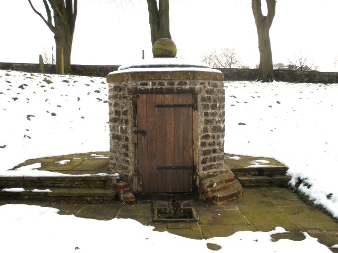
Close to the Roman road, this spring must be ancient. As a Christian holy site, it is surely Saxon in origin, like the village itself. It may be as old as the seventh century, with a possible dedication to St Oswald, beheaded in 654. Enclosed in the ninth century, with the present stone church begun nearby in the twelfth. In 1764, it was covered with a small, elegant octagonal building (symbolizing baptism?) by the rector, Mr Henry Richardson, who seems to have been interested in the healing qualities of its waters - 'fons salutifer' is the phrase he used in his Latin inscription. Neglected for many years, it was restored in 2005, with a wheelchair access path added in 2006. Further improvements are continuing.
Church Well stands in the St Mary's churchyard beside the Skipton road a few miles east of Barnoldswick. The 18th century wellhouse has recently been restored. Within is an ancient spring that once had curative powers and was a place of pilgrimage.
The spring pre-dates Christianity but, in the Anglo-Saxon period it became a centre of activity when a small church of sorts was founded close to it, though the well itself was already being used as a place for worship and baptisms. The present church of St Mary dates in part from the 12th century.
The octagonal wellhouse enclosing the spring was built in 1764 by the local rector, Henry Richardson (1710-78) in order to protect it. Recently, in 2005, the little building was restored and is now Grade 2 listed. Even today it remains a place of pilgrimage and "sprinkling" ceremonies are still held here.
An inscription in Latin runs around the top of the wellhouse and is as follows: FOUTEM HUNC SALUTIFERUM ET PER ANTIQUUM TECTO MUNIVIT ANNO ERAE CHRISTIANES MDCCLXIV QUAD PUBLICAE SANITATI BENE VORTAT or translated 'This Health Giving and Ancient Well covered in the year of the Christian Era 1764 may It Prove To Be A Blessing To Mankind'.
You may be viewing yesterday's version of this page. To see the most up to date information please register for a free account.


Do not use the above information on other web sites or publications without permission of the contributor.
Click here to see more info for this site
Nearby sites
Key: Red: member's photo, Blue: 3rd party photo, Yellow: other image, Green: no photo - please go there and take one, Grey: site destroyed
Download sites to:
KML (Google Earth)
GPX (GPS waypoints)
CSV (Garmin/Navman)
CSV (Excel)
To unlock full downloads you need to sign up as a Contributory Member. Otherwise downloads are limited to 50 sites.
Turn off the page maps and other distractions
Nearby sites listing. In the following links * = Image available
100m E 90° Church Well (Thornton-in-Craven)* Holy Well or Sacred Spring (SD902483)
2.5km NNE 16° St Peter (East Marton)* Ancient Cross (SD9080750694)
2.9km ESE 102° Hare Hill ring cairn* Cairn (SD9295347697)
3.1km SSW 201° Jinny Well, Salterforth* Holy Well or Sacred Spring (SD8898145411)
3.2km SE 145° Bleara Moor Cairnfield (Earby) Cairn (SD919457)
3.7km SE 141° Bleara Moor Cairn* Cairn (SD9242745396)
3.9km SE 139° Bleara Lowe* Cairn (SD9266145388)
4.1km E 87° Standrise Earth Circle (Carleton in Craven) Misc. Earthwork (SD94194847)
5.4km WSW 259° Primrose Hill (Gisburn) Misc. Earthwork (SD84764725)
5.6km SSW 202° The Lark Hill Stone (Whitemoor)* Standing Stone (Menhir) (SD880431)
5.7km ENE 57° Broughton Circle Stone Circle (SD9490551404)
5.8km W 263° Bomber Camp (Gisburn) Ancient Village or Settlement (SD8429547626)
6.1km S 190° Tallers Cross* Ancient Cross (SD890423)
6.1km NW 326° Cobers Laithe Camp (Nappa)* Misc. Earthwork (SD86695340)
6.2km NNE 28° The Garris* Ancient Village or Settlement (SD9306153776)
6.4km NNE 29° St Andrew (Gargrave)* Ancient Cross (SD93205391)
6.5km NE 36° Kirk Sink (Gargrave) Ancient Village or Settlement (SD9396753517)
6.5km NNE 28° Roman Ford (Gargrave)* Ancient Trackway (SD9316354086)
6.9km WSW 243° Middop Earthworks* Misc. Earthwork (SD839452)
7.0km NNW 347° Steeling Hill Enclosure Ancient Village or Settlement (SD8859255148)
7.2km SSE 166° Cold Well (Laneshawbridge)* Holy Well or Sacred Spring (SD91804125)
7.4km ESE 106° Babyhouse Lane (Cononley) Ancient Village or Settlement (SD97194627)
7.5km WNW 284° Little Painley* Round Barrow(s) (SD8284350125)
7.5km WNW 289° Castle Haugh Ringwork (Paythorne Bridge) Misc. Earthwork (SD8299650776)
7.7km SSW 197° Alkincoats Cross (Colne) Ancient Cross (SD87894094)
View more nearby sites and additional images


 We would like to know more about this location. Please feel free to add a brief description and any relevant information in your own language.
 Wir möchten mehr über diese Stätte erfahren. Bitte zögern Sie nicht, eine kurze Beschreibung und relevante Informationen in Deutsch hinzuzufügen.
 Nous aimerions en savoir encore un peu sur les lieux. S'il vous plaît n'hesitez pas à ajouter une courte description et tous les renseignements pertinents dans votre propre langue.
 Quisieramos informarnos un poco más de las lugares. No dude en añadir una breve descripción y otros datos relevantes en su propio idioma.