<< Our Photo Pages >> High Lea Farm - Barrow Cemetery in England in Dorset

Submitted by JimChampion on Monday, 07 July 2008  Page Views: 9599

Neolithic and Bronze AgeSite Name: High Lea Farm
Country: England
NOTE: This site is 2.272 km away from the location you searched for.

County: Dorset Type: Barrow Cemetery
Nearest Town: Wimborne  Nearest Village: Witchampton
Map Ref: ST999061
Latitude: 50.854415N  Longitude: 2.00279W
Condition:
5Perfect
4Almost Perfect
3Reasonable but with some damage
2Ruined but still recognisable as an ancient site
1Pretty much destroyed, possibly visible as crop marks
0No data.
-1Completely destroyed
1 Ambience:
5Superb
4Good
3Ordinary
2Not Good
1Awful
0No data.
no data Access:
5Can be driven to, probably with disabled access
4Short walk on a footpath
3Requiring a bit more of a walk
2A long walk
1In the middle of nowhere, a nightmare to find
0No data.
4 Accuracy:
5co-ordinates taken by GPS or official recorded co-ordinates
4co-ordinates scaled from a detailed map
3co-ordinates scaled from a bad map
2co-ordinates of the nearest village
1co-ordinates of the nearest town
0no data
4

Internal Links:
External Links:

High Lea Farm
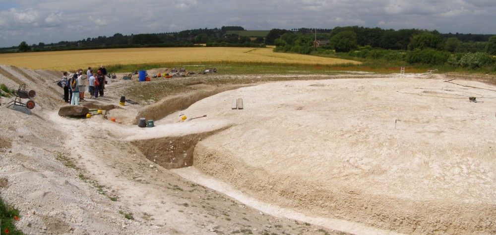
High Lea Farm submitted by JimChampion : The excavated round barrow at High Lea Farm, part of Bournemouth University's "Knowlton Prehistoric Landscape Project'. Seen from the spoil heap on the open day (Sunday 29 June 2008). The site was being prepared for mast-cam photographs two days later. This is a composite image from two photographs. (Vote or comment on this photo)
Barrow Cemetery in Dorset This group comprises a barrow cemetery composed of round barrows and oval barrows. Only a small number of the barrows are visible as earthworks, the remainder are visible as cropmarks on aerial photographs. [source]

The High Lea Farm site is the current focus of Bournemouth University's School of Conservation Sciences "Knowlton Prehistoric Landscape Project": an archaeological investigation into the prehistoric relict landscape located within the Allen valley. The site contains an Early Bronze Age barrow cemetery and a recently discovered Late Iron Age/Romano-British settlement complex. This 2008 campaign was the final season of excavation at the site, continuing the excavation of the barrow cemetery begun in 2003, and completing the excavation of a well preserved round barrow and pre-barrow mortuary structure. The project was extended for 2008 to ensure the excavation of Beaker settlement that lies underneath the the pre-barrow mortuary structure. [source]

Note: New photos and information on the Knowlton Prehistoric Landscape Project
You may be viewing yesterday's version of this page. To see the most up to date information please register for a free account.


High Lea Farm
High Lea Farm submitted by JimChampion : Resting on the ground, a sarsen stone uncovered by the operator of the mechanical digger that stripped the topsoil from the site (several years ago). (1 comment - Vote or comment on this photo)

High Lea Farm
High Lea Farm submitted by JimChampion : The excavated barrow ditch, on the west side. The area to the left of the barrow was excavated last year, this year the disturbed ground is home to many poppies. (Vote or comment on this photo)

High Lea Farm
High Lea Farm submitted by JimChampion : The west side of the excavated round barrow, viewed from the neighbouring spoil heap. The barrow has been explored over several seasons as part of Bournemouth University's 'Knowlton Prehistoric Landscape' project. Here the site is in the process of being prepared for aerial photography later in the week. (Vote or comment on this photo)

High Lea Farm
High Lea Farm submitted by JimChampion : The eastern half of the excavated barrow, clearly showing the broad flat-bottomed surrounding ditch. The site has been excavated each summer since 2003, and then backfilled at the end of each season. The darker area in the cross-section at the middle of the barrow shows where turves were stacked to form the barrow mound. (Vote or comment on this photo)

High Lea Farm
High Lea Farm submitted by JimChampion : In the foreground is the excavated round barrow. On the far side of the field a slight rise in the ground is another barrow in the cemetery, the only scheduled ancient monument in the group. The 'entrance' to the pre-barrow mortuary enclosure is aligned on the scheduled barrow across the field. The trees on the high ground in the far distance are within Badbury Rings hillfort. (2 comments - Vote or comment on this photo)

High Lea Farm
High Lea Farm submitted by JimChampion : Excavation at High Lea Farm, seen on the open day (29 June 2008). The square pit is part of the pre-barrow mortuary structure - a yellow rope marks the encircling stake-holes. The blue rope marks a possible dwelling from a Beaker settlement. The Knowlton Prehistoric Landscape project is run by the School of Conservation Sciences at Bournemouth University as a field school for its undergraduate and...

Do not use the above information on other web sites or publications without permission of the contributor.
Click here to see more info for this site

Nearby sites

Click here to view sites on an interactive OS map

Key: Red: member's photo, Blue: 3rd party photo, Yellow: other image, Green: no photo - please go there and take one, Grey: site destroyed

Download sites to:
KML (Google Earth)
GPX (GPS waypoints)
CSV (Garmin/Navman)
CSV (Excel)

To unlock full downloads you need to sign up as a Contributory Member. Otherwise downloads are limited to 50 sites.


Turn off the page maps and other distractions

Nearby sites listing. In the following links * = Image available
 3.4km E 97° Colebarrow* Hillfort (SU033057)
 3.8km SSE 166° Bakers Dozen* Modern Stone Circle etc (SU008024)
 4.5km NNE 33° Knowlton Great Circle* Henge (SU024099)
 4.7km SW 228° Badbury Rings* Hillfort (ST96400299)
 4.9km NNE 31° Knowlton Rings* Henge (SU02381028)
 4.9km NNE 32° Knowlton Great Barrow* Round Barrow(s) (SU02541027)
 5.2km SW 232° Badbury Barrow Barrow Cemetery (ST958029)
 5.3km ENE 77° Roman Barrow, Knob's Crook* Round Barrow(s) (SU051073)
 5.3km NE 36° Knowle Hill Farm long barrow* Long Barrow (SU0306210415)
 5.6km NNW 341° Parsonage Hill* Long Barrow (ST98131137)
 5.7km ESE 102° Holt Heath* Round Barrow(s) (SU055049)
 5.8km S 184° Pamphill* Natural Stone / Erratic / Other Natural Feature (ST995003)
 6.0km WSW 240° Straw Barrow Round Barrow(s) (ST94660312)
 6.5km ENE 78° David's Cross* Round Barrow(s) (SU063074)
 6.7km NNW 335° Thickthorn Round Barrows* Round Barrow(s) (ST971122)
 6.7km NNW 335° Thickthorn Down (South)* Long Barrow (ST971122)
 6.8km NNW 335° Thickthorn Down (North)* Long Barrow (ST970123)
 6.9km S 191° The Bearstone* Standing Stone (Menhir) (SY986993)
 7.0km NNW 335° Gussage St Michael Cursus Cursus (ST969124)
 7.0km N 354° Gussage South-East Long Barrow (ST992131)
 7.2km ENE 67° Woodlands Common Barrow* Round Barrow(s) (SU065089)
 7.4km NNW 338° Ogden Down 3 Timber Circle (ST971129)
 7.4km NE 34° Wimborne St Giles* Round Barrow(s) (SU041122)
 7.5km E 79° Redman's Hill Barrow* Round Barrow(s) (SU073075)
 7.5km N 356° Gussage Down (South)* Long Barrow (ST994136)
View more nearby sites and additional images

<< GoJeong-ri dolmens

Anta da Coutada de Barbacena >>

Please add your thoughts on this site

Prehistoric Dorset

Prehistoric Dorset

Sponsors

Auto-Translation (Google)

Translate from English into:

"High Lea Farm" | Login/Create an Account | 4 News and Comments
  
Go back to top of page    Comments are owned by the poster. We aren't responsible for their content.
Knowlton Prehistoric Landscape Project by Andy B on Wednesday, 05 October 2011
(User Info | Send a Message)
The Knowlton Prehistoric Landscape Project is an archaeological investigation into the prehistoric relict landscape located within the Allen valley in the county of Dorset, England, UK. The Allen valley is a modest river valley situated on chalk down land at the eastern side of Cranborne Chase, an area which encompasses one of the densest concentrations of prehistoric monuments in north-west Europe. The area has attracted the attention of archaeologists from as early as the late 19th century and has become one of the most intensely studied landscapes in the UK. However, parts of Cranborne Chase remain little understood and the Allen valley is potentially one of the most interesting of them.

Site appears rather out of date but more at
http://csweb.bmth.ac.uk/knp/index.html
[ Reply to This ]

The Talk on the Knowlton Prehistoric Landscape Project, 11 Oct 2011, Salisbury by Andy B on Wednesday, 05 October 2011
(User Info | Send a Message)
The Knowlton Prehistoric Landscape Project – We know a lot about Round Barrows don’t we?

When: 11 Oct 2011 19:30
Where: Lecture Hall - Salisbury & South Wiltshire Museum
Category: Lectures Description
A talk by John Gale, Senior Lecturer in Archaeology, Bournemouth University.

“Round Barrows – That’s where Bronze Age people buried their dead init! Nuff said”. Factually correct, if a tad simplistic, but of course the potential for learning more about society from studying these monuments it could be argued is still in its infancy. The landscape of Cranborne Chase has been at the forefront of British prehistory and archaeology since the middle of the 19th century, it having one of the densest concentrations of prehistoric monuments in north-west Europe.

In 2003 John Gale embarked upon a seasonal campaign of excavations at the little known and apparently flattened barrow group at High Lea Farm near Hinton Martell north of Wimborne. The fieldwork was completed in 2009 and the analysis currently under way is discovering information which suggests that we still have a lot to learn about these ‘familiar’ monuments of the Wessex landscape.

John will also be incorporating some early results of his recent survey work at the Clandon Barrow in west Dorset which has a bearing on the lecture title.

No booking necessary, payable on the door

Cost: Museum members £2.00; non-Members £3.50; payable on the door

http://www.salisburymuseum.org.uk/what-s-on/lectures/188-the-knowlton-prehistoric-landscape-project-–-we-know-a-lot-about-round-barrows-dont-we.html
[ Reply to This ]

Street View by coldrum on Friday, 26 March 2010
(User Info | Send a Message)

View Larger Map
[ Reply to This ]

Re: High Lea Farm by Anonymous on Thursday, 16 October 2008
There is no public access to this site as it is located on private land. The footpath referred to was not a public footpath and was only open for one day during the archaeological excavations.
[ Reply to This ]

Your Name: Anonymous [ Register Now ]
Subject:


Add your comment or contribution to this page. Spam or offensive posts are deleted immediately, don't even bother

<<< What is five plus one as a number? (Please type the answer to this question in the little box on the left)
You can also embed videos and other things. For Youtube please copy and paste the 'embed code'.
For Google Street View please include Street View in the text.
Create a web link like this: <a href="https://www.megalithic.co.uk">This is a link</a>  

Allowed HTML is:
<p> <b> <i> <a> <img> <em> <br> <strong> <blockquote> <tt> <li> <ol> <ul> <object> <param> <embed> <iframe>

We would like to know more about this location. Please feel free to add a brief description and any relevant information in your own language.
Wir möchten mehr über diese Stätte erfahren. Bitte zögern Sie nicht, eine kurze Beschreibung und relevante Informationen in Deutsch hinzuzufügen.
Nous aimerions en savoir encore un peu sur les lieux. S'il vous plaît n'hesitez pas à ajouter une courte description et tous les renseignements pertinents dans votre propre langue.
Quisieramos informarnos un poco más de las lugares. No dude en añadir una breve descripción y otros datos relevantes en su propio idioma.