

<< Our Photo Pages >> Gussage Down (South) - Long Barrow in England in Dorset
Submitted by JimChampion on Thursday, 07 April 2005 Page Views: 8284
Neolithic and Bronze AgeSite Name: Gussage Down (South) Alternative Name: Gussage St Michael 4, Gussage Cow Down SouthCountry: England County: Dorset Type: Long Barrow
Nearest Town: Blandford Forum Nearest Village: Gussage St Michael
Map Ref: ST994136
Latitude: 50.921858N Longitude: 2.009908W
Condition:
| 5 | Perfect |
| 4 | Almost Perfect |
| 3 | Reasonable but with some damage |
| 2 | Ruined but still recognisable as an ancient site |
| 1 | Pretty much destroyed, possibly visible as crop marks |
| 0 | No data. |
| -1 | Completely destroyed |
| 5 | Superb |
| 4 | Good |
| 3 | Ordinary |
| 2 | Not Good |
| 1 | Awful |
| 0 | No data. |
| 5 | Can be driven to, probably with disabled access |
| 4 | Short walk on a footpath |
| 3 | Requiring a bit more of a walk |
| 2 | A long walk |
| 1 | In the middle of nowhere, a nightmare to find |
| 0 | No data. |
| 5 | co-ordinates taken by GPS or official recorded co-ordinates |
| 4 | co-ordinates scaled from a detailed map |
| 3 | co-ordinates scaled from a bad map |
| 2 | co-ordinates of the nearest village |
| 1 | co-ordinates of the nearest town |
| 0 | no data |
Internal Links:
External Links:
I have visited· I would like to visit
h_fenton visited on 20th Feb 2002 - their rating: Access: 2
JimChampion have visited here
 (PID:12943)")
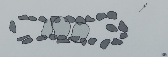
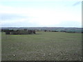
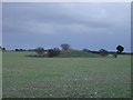
As with many of the long barrows in this region its long axis points SE-NW, with the wider flatter end to the SE. It stands atop the ridge of Gussage Down but would only have been intervisible with the nearby long barrow to the NW. This barrow has a U-shaped ditch (now silted up and ploughed over) with the open end at the NW, pointing towards its similarly sized companion long barrow about 200m further along the ridge (which lay within the banks of the Dorset Cursus).
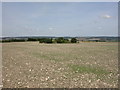
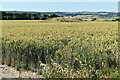
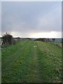
Access This long barrow stands in an arable field and is surrounded by crops. A bridleway (The Jubilee trail) passes very close by along the ridge of Gussage Down, and makes a T junction with another bridleway coming up Gussage Hill from the hamlet of Gussage St Michael. For details of how to walk to this barrow see the entry for the neighbouring northern barrow.
You may be viewing yesterday's version of this page. To see the most up to date information please register for a free account.
 (PID:272138)")
 (PID:272137)")
 (PID:36546)")
 (PID:12946)")
Do not use the above information on other web sites or publications without permission of the contributor.
Nearby Images from Geograph Britain and Ireland:
©2009(licence)
©2022(licence)
©2006(licence)
©2006(licence)
©2006(licence)
The above images may not be of the site on this page, they are loaded from Geograph.
Please Submit an Image of this site or go out and take one for us!
Click here to see more info for this site
Nearby sites
Key: Red: member's photo, Blue: 3rd party photo, Yellow: other image, Green: no photo - please go there and take one, Grey: site destroyed
Download sites to:
KML (Google Earth)
GPX (GPS waypoints)
CSV (Garmin/Navman)
CSV (Excel)
To unlock full downloads you need to sign up as a Contributory Member. Otherwise downloads are limited to 50 sites.
Turn off the page maps and other distractions
Nearby sites listing. In the following links * = Image available
223m NNW 333° Gussage Down (North)* Long Barrow (ST993138)
538m SSW 202° Gussage South-East Long Barrow (ST992131)
565m NW 315° Gussage Hill Ancient Village or Settlement (ST990140)
1.9km E 88° Monkton-up-Wimborne Late Neolithic pit circle/shaft complex* Misc. Earthwork (SU01311367)
2.1km NE 35° Wyke Down henge* Henge (SU006153)
2.2km NE 43° Wyke Down barrows* Round Barrow(s) (SU009152)
2.3km ENE 61° Drive Plantation* Long Barrow (SU014147)
2.4km WSW 253° Ogden Down 3 Timber Circle (ST971129)
2.6km SSW 210° Parsonage Hill* Long Barrow (ST98131137)
2.7km WSW 239° Thickthorn Round Barrows* Round Barrow(s) (ST971122)
2.7km WSW 239° Thickthorn Down (South)* Long Barrow (ST971122)
2.7km WSW 241° Thickthorn Down (North)* Long Barrow (ST970123)
2.8km WSW 244° Gussage St Michael Cursus Cursus (ST969124)
2.9km NE 46° Pentridge Cursus Cursus (SU015156)
2.9km NE 46° Gussage St Michael Cursus Cursus (SU015156)
3.0km W 261° Thickthorn Farm Long Barrow (ST964131)
3.3km NE 37° Bottlebush Down barrows* Barrow Cemetery (SU01381625)
3.4km NE 44° Dorset Cursus* Cursus (SU01751600)
4.1km NNE 26° Wor Barrow* Long Barrow (SU01241729)
4.4km W 260° Chettle House* Long Barrow (ST9506612803)
4.4km NNE 33° Oakley Down Barrows* Barrow Cemetery (SU01821731)
4.5km SE 138° Knowlton Rings* Henge (SU02381028)
4.5km NE 43° Pentridge 4* Long Barrow (SU025169)
4.6km SE 137° Knowlton Great Barrow* Round Barrow(s) (SU02541027)
4.8km SE 141° Knowlton Great Circle* Henge (SU024099)
View more nearby sites and additional images


 We would like to know more about this location. Please feel free to add a brief description and any relevant information in your own language.
 Wir möchten mehr über diese Stätte erfahren. Bitte zögern Sie nicht, eine kurze Beschreibung und relevante Informationen in Deutsch hinzuzufügen.
 Nous aimerions en savoir encore un peu sur les lieux. S'il vous plaît n'hesitez pas à ajouter une courte description et tous les renseignements pertinents dans votre propre langue.
 Quisieramos informarnos un poco más de las lugares. No dude en añadir una breve descripción y otros datos relevantes en su propio idioma.