<< Other Photo Pages >> Nunalleq - Ancient Village or Settlement in United States in Alaska
Submitted by bat400 on Wednesday, 28 August 2013 Page Views: 7775
DigsSite Name: NunalleqCountry: United States
NOTE: This site is 570.99 km away from the location you searched for.
Region: Alaska Type: Ancient Village or Settlement
Nearest Village: Quinhagak, AK
Latitude: 59.753000N Longitude: 161.903W
Condition:
| 5 | Perfect |
| 4 | Almost Perfect |
| 3 | Reasonable but with some damage |
| 2 | Ruined but still recognisable as an ancient site |
| 1 | Pretty much destroyed, possibly visible as crop marks |
| 0 | No data. |
| -1 | Completely destroyed |
| 5 | Superb |
| 4 | Good |
| 3 | Ordinary |
| 2 | Not Good |
| 1 | Awful |
| 0 | No data. |
| 5 | Can be driven to, probably with disabled access |
| 4 | Short walk on a footpath |
| 3 | Requiring a bit more of a walk |
| 2 | A long walk |
| 1 | In the middle of nowhere, a nightmare to find |
| 0 | No data. |
| 5 | co-ordinates taken by GPS or official recorded co-ordinates |
| 4 | co-ordinates scaled from a detailed map |
| 3 | co-ordinates scaled from a bad map |
| 2 | co-ordinates of the nearest village |
| 1 | co-ordinates of the nearest town |
| 0 | no data |
Internal Links:
External Links:
I have visited· I would like to visit
Andy B has visited here
")
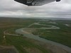
Finds are rapidly being uncovered as the arctic perafrost melts. Communial house sites (partially below ground square buildings of drift wood, covered by earth and snow) and many household artifacts have been found. Finds include ivory, woven grass, incredibly well preserved animal remains, animal fur and human hair.
The University of Aberdeen Department of Archaeology, in partnership with the village corporation Qanirtuuq, Inc. and the Yup’ik Eskimo village of Quinhagak, Alaska, is working to record archaeological sites threatened by rising sea levels along the Bering Sea.
Nunalleq means ‘the OldVillage’ in Yup’ik. and was occupied from 1350-1650AD, during the "Little Ice Age". The waterlogged frozen tundra preserves organic material to an incredible degree. Everything from grass ropes, salmon berry seeds and head lice, along with an abundance of wooden and lithic artefacts and faunal remains builds the knowledge of a Yup’ik prehistory that up until now has been very little known or studied.
Note: More spectacularly well preserved finds such as this human / animal transformational mask uncovered by the 2013 dig season. More in their illustrated dig diary
You may be viewing yesterday's version of this page. To see the most up to date information please register for a free account.
")
")
")
Do not use the above information on other web sites or publications without permission of the contributor.
Nearby Images from Flickr


The above images may not be of the site on this page, but were taken nearby. They are loaded from Flickr so please click on them for image credits.
Click here to see more info for this site
Nearby sites
Click here to view sites on an interactive map of the areaKey: Red: member's photo, Blue: 3rd party photo, Yellow: other image, Green: no photo - please go there and take one, Grey: site destroyed
Download sites to:
KML (Google Earth)
GPX (GPS waypoints)
CSV (Garmin/Navman)
CSV (Excel)
To unlock full downloads you need to sign up as a Contributory Member. Otherwise downloads are limited to 50 sites.
Turn off the page maps and other distractions
Nearby sites listing. In the following links * = Image available
558.6km NNW 342° Snake River Sandspit Pithouses Ancient Village or Settlement
711.8km SSW 205° Amaknak Bridge Ancient Village or Settlement
838.2km N 11° Onion Portage Archaeological District* Ancient Village or Settlement
892.7km NW 315° Un'en'en Ancient Village or Settlement
917.7km ENE 60° Tangle Lakes Archaeological District* Ancient Village or Settlement
962.9km N 9° Feniak Lake* Rock Art
968.9km NE 53° Swan Point Archaeological Site* Ancient Village or Settlement
976.8km NE 53° Upward Sun River* Ancient Village or Settlement
1315.7km N 8° Birnirk National Historic Landmark* Artificial Mound
1321.0km NE 43° Bluefish Caves* Cave or Rock Shelter
1474.2km ENE 74° Yukon Beringia Interpretive Centre* Museum
1550.2km NW 324° Petroglyphs of Pegtymel River* Rock Art
1584.7km E 89° Hidden Falls Ancient Village or Settlement
1695.0km E 91° On-Your-Knees Cave* Cave or Rock Shelter
1755.4km E 89° Petroglyph Beach* Rock Art
1966.6km E 94° Lucy Islands Ancient Village or Settlement
2037.2km E 100° Gwaii Haanas Caves Cave or Rock Shelter
2079.9km E 89° 'Ksan Historical Village and Museum* Museum
2302.5km E 95° Nuxalk Petroglyphs Rock Art
2418.4km E 88° Beaverly Workshop Ancient Mine, Quarry or other Industry
2498.8km W 270° Kamchatka Geological Museum* Museum
2523.2km E 98° Ancient clam gardens on Quadra Island* Ancient Mine, Quarry or other Industry
2580.0km E 99° Comox Estuary* Ancient Village or Settlement
2580.5km E 99° Comox Harbor Ancient Fish Trap* Ancient Mine, Quarry or other Industry
2592.4km E 98° Pictographs near Powell River ferry terminal Rock Art
View more nearby sites and additional images


 We would like to know more about this location. Please feel free to add a brief description and any relevant information in your own language.
 Wir möchten mehr über diese Stätte erfahren. Bitte zögern Sie nicht, eine kurze Beschreibung und relevante Informationen in Deutsch hinzuzufügen.
 Nous aimerions en savoir encore un peu sur les lieux. S'il vous plaît n'hesitez pas à ajouter une courte description et tous les renseignements pertinents dans votre propre langue.
 Quisieramos informarnos un poco más de las lugares. No dude en añadir una breve descripción y otros datos relevantes en su propio idioma.