<< Other Photo Pages >> Tomo Kahni - Rock Art in United States in The West
Submitted by bat400 on Sunday, 20 September 2015 Page Views: 23840
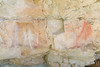
Rock ArtSite Name: Tomo Kahni Alternative Name: Tomo-Kahni State Historic Park, Tehachapi Native American Village SiteCountry: United States
NOTE: This site is 41.078 km away from the location you searched for.
Region: The West Type: Rock Art
Nearest Town: Tehachapi, Calif.
Latitude: 35.148000N Longitude: 118.335W
Condition:
| 5 | Perfect |
| 4 | Almost Perfect |
| 3 | Reasonable but with some damage |
| 2 | Ruined but still recognisable as an ancient site |
| 1 | Pretty much destroyed, possibly visible as crop marks |
| 0 | No data. |
| -1 | Completely destroyed |
| 5 | Superb |
| 4 | Good |
| 3 | Ordinary |
| 2 | Not Good |
| 1 | Awful |
| 0 | No data. |
| 5 | Can be driven to, probably with disabled access |
| 4 | Short walk on a footpath |
| 3 | Requiring a bit more of a walk |
| 2 | A long walk |
| 1 | In the middle of nowhere, a nightmare to find |
| 0 | No data. |
| 5 | co-ordinates taken by GPS or official recorded co-ordinates |
| 4 | co-ordinates scaled from a detailed map |
| 3 | co-ordinates scaled from a bad map |
| 2 | co-ordinates of the nearest village |
| 1 | co-ordinates of the nearest town |
| 0 | no data |
Internal Links:
External Links:
")
Due to the extremely sensitive nature of the site, visitation is only permitted on a guided tour, which involves a moderately strenuous 3-hour hike.
Tomo Kahni State Historic Park.
Tours of the cave are available/ Reservations are required. [unfortunate pun not intended? - MegP Ed]
Note: October tours of the Tehachapi Native American Village Site booking now, and see the link for more California Archaeology Month events
You may be viewing yesterday's version of this page. To see the most up to date information please register for a free account.
")
")
")
Do not use the above information on other web sites or publications without permission of the contributor.
Nearby Images from Flickr


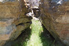
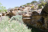

The above images may not be of the site on this page, but were taken nearby. They are loaded from Flickr so please click on them for image credits.
Click here to see more info for this site
Nearby sites
Click here to view sites on an interactive map of the areaKey: Red: member's photo, Blue: 3rd party photo, Yellow: other image, Green: no photo - please go there and take one, Grey: site destroyed
Download sites to:
KML (Google Earth)
GPX (GPS waypoints)
CSV (Garmin/Navman)
CSV (Excel)
To unlock full downloads you need to sign up as a Contributory Member. Otherwise downloads are limited to 50 sites.
Turn off the page maps and other distractions
Nearby sites listing. In the following links * = Image available
74.3km S 179° Tataviam Pictograph Site* Rock Art
79.2km WSW 258° Wind Wolves Preserve* Rock Art
103.9km E 87° Inscription Canyon* Rock Art
104.1km NNW 341° Painted Rock at Tule River Rock Art
114.7km NE 35° Coso Petroglyphs* Rock Art
120.5km S 181° Levitated Mass* Modern Stone Circle etc
138.6km W 270° Painted Rock, Carrizo Plain* Rock Art
148.6km WSW 237° Burton Mound* Artificial Mound
150.7km WSW 242° Chumash Painted Cave* Cave or Rock Shelter
162.3km S 171° Bolsa Chica Mesa* Ancient Village or Settlement
166.1km NNE 14° Swansea petroglyph site* Rock Art
191.8km SE 142° Hemet Maze Stone* Rock Art
223.9km E 88° 17 Mile Point* Rock Art
226.5km WSW 238° California Channel Islands* Ancient Village or Settlement
226.5km W 276° Los Osos Back Bay* Ancient Village or Settlement
230.2km W 277° Morro Creek* Ancient Village or Settlement
233.6km SE 139° Anza Fertility Site* Natural Stone / Erratic / Other Natural Feature
234.4km ESE 116° Archaeology and Paleontology Curation Center Museum
235.4km ESE 121° Brunette Lady* Rock Art
235.8km ESE 121° Barker Dam Trail* Rock Art
236.4km ESE 121° Red lady* Rock Art
246.2km N 358° Bishop Eastern Sierra Petroglyphs* Rock Art
260.7km SSE 151° San Diego Archaeological Centre* Museum
267.7km E 92° Hole-in-the-Wall* Rock Art
273.1km E 92° Tortoise Shell Mountain* Rock Art
View more nearby sites and additional images


 We would like to know more about this location. Please feel free to add a brief description and any relevant information in your own language.
 Wir möchten mehr über diese Stätte erfahren. Bitte zögern Sie nicht, eine kurze Beschreibung und relevante Informationen in Deutsch hinzuzufügen.
 Nous aimerions en savoir encore un peu sur les lieux. S'il vous plaît n'hesitez pas à ajouter une courte description et tous les renseignements pertinents dans votre propre langue.
 Quisieramos informarnos un poco más de las lugares. No dude en añadir una breve descripción y otros datos relevantes en su propio idioma.