

<< Our Photo Pages >> Barker Dam Trail - Rock Art in United States in The Southwest
Submitted by mfrincu on Sunday, 19 April 2015 Page Views: 1855
Rock ArtSite Name: Barker Dam TrailCountry: United States Region: The Southwest Type: Rock Art
Nearest Town: Joshua Tree
Latitude: 34.028211N Longitude: 116.147912W
Condition:
| 5 | Perfect |
| 4 | Almost Perfect |
| 3 | Reasonable but with some damage |
| 2 | Ruined but still recognisable as an ancient site |
| 1 | Pretty much destroyed, possibly visible as crop marks |
| 0 | No data. |
| -1 | Completely destroyed |
| 5 | Superb |
| 4 | Good |
| 3 | Ordinary |
| 2 | Not Good |
| 1 | Awful |
| 0 | No data. |
| 5 | Can be driven to, probably with disabled access |
| 4 | Short walk on a footpath |
| 3 | Requiring a bit more of a walk |
| 2 | A long walk |
| 1 | In the middle of nowhere, a nightmare to find |
| 0 | No data. |
| 5 | co-ordinates taken by GPS or official recorded co-ordinates |
| 4 | co-ordinates scaled from a detailed map |
| 3 | co-ordinates scaled from a bad map |
| 2 | co-ordinates of the nearest village |
| 1 | co-ordinates of the nearest town |
| 0 | no data |
Internal Links:
External Links:
I have visited· I would like to visit
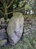
mfrincu visited on 10th Oct 2014 Easy to find and spot right on the Barker Dam Trail. Contains few artwork panels in good shape. What it is nice about this place it's that it combines both pictographs and petroglyphs.
")
This beautiful petroglyph site can be visited while doing the 1.5 mile Barker Dam loop which starts in the Barker Dam parking lot. It is an easy hike and you are rewarded with beautiful scenery on your way to the site. The site itself is very well preserved containing both pictographs and petroglyphs. As in any petroglyph site try to be there early morning or late evening. These are the best times to take pictures!
You may be viewing yesterday's version of this page. To see the most up to date information please register for a free account.
")
Do not use the above information on other web sites or publications without permission of the contributor.
Nearby Images from Flickr


The above images may not be of the site on this page, but were taken nearby. They are loaded from Flickr so please click on them for image credits.
Click here to see more info for this site
Nearby sites
Click here to view sites on an interactive map of the areaKey: Red: member's photo, Blue: 3rd party photo, Yellow: other image, Green: no photo - please go there and take one, Grey: site destroyed
Download sites to:
KML (Google Earth)
GPX (GPS waypoints)
CSV (Garmin/Navman)
CSV (Excel)
To unlock full downloads you need to sign up as a Contributory Member. Otherwise downloads are limited to 50 sites.
Turn off the page maps and other distractions
Nearby sites listing. In the following links * = Image available
653m ESE 105° Red lady* Rock Art
818m SW 236° Brunette Lady* Rock Art
19.7km NNE 26° Archaeology and Paleontology Curation Center Museum
71.6km SW 223° Anza Fertility Site* Natural Stone / Erratic / Other Natural Feature
88.2km ESE 120° Corn Springs* Rock Art
88.2km WSW 252° Hemet Maze Stone* Rock Art
129.8km SW 217° San Diego Archaeological Centre* Museum
132.2km NNE 31° Hole-in-the-Wall* Rock Art
133.4km N 11° 17 Mile Point* Rock Art
134.8km NNE 33° Tortoise Shell Mountain* Rock Art
151.2km E 99° Blythe Intaglios* Hill Figure or Geoglyph
161.5km NW 324° Inscription Canyon* Rock Art
169.6km ENE 63° Topock Maze* Misc. Earthwork
178.9km W 259° Bolsa Chica Mesa* Ancient Village or Settlement
188.8km NE 45° Grapevine Canyon* Rock Art
203.9km W 272° Levitated Mass* Modern Stone Circle etc
205.6km WNW 285° Tataviam Pictograph Site* Rock Art
231.5km NNE 25° Sloan Petroglyph Site* Rock Art
235.8km WNW 302° Tomo Kahni* Rock Art
243.3km NNE 15° Lost Creek* Rock Art
246.8km SE 126° Antelope Hill Ancient Mine, Quarry or other Industry
256.0km NNW 329° Coso Petroglyphs* Rock Art
269.2km NNE 25° Gypsum Cave Cave or Rock Shelter
285.7km ESE 115° Sears Point* Rock Art
298.3km WNW 292° Wind Wolves Preserve* Rock Art
View more nearby sites and additional images

")
 We would like to know more about this location. Please feel free to add a brief description and any relevant information in your own language.
 Wir möchten mehr über diese Stätte erfahren. Bitte zögern Sie nicht, eine kurze Beschreibung und relevante Informationen in Deutsch hinzuzufügen.
 Nous aimerions en savoir encore un peu sur les lieux. S'il vous plaît n'hesitez pas à ajouter une courte description et tous les renseignements pertinents dans votre propre langue.
 Quisieramos informarnos un poco más de las lugares. No dude en añadir una breve descripción y otros datos relevantes en su propio idioma.