<< Other Photo Pages >> Gila Cliff Dwellings - Ancient Village or Settlement in United States in The Southwest
Submitted by bat400 on Monday, 14 January 2013 Page Views: 4145
Multi-periodSite Name: Gila Cliff DwellingsCountry: United States
NOTE: This site is 53.771 km away from the location you searched for.
Region: The Southwest Type: Ancient Village or Settlement
Nearest Town: Albuquerque Nearest Village: Silver City, NM
Latitude: 33.230000N Longitude: 108.265W
Condition:
| 5 | Perfect |
| 4 | Almost Perfect |
| 3 | Reasonable but with some damage |
| 2 | Ruined but still recognisable as an ancient site |
| 1 | Pretty much destroyed, possibly visible as crop marks |
| 0 | No data. |
| -1 | Completely destroyed |
| 5 | Superb |
| 4 | Good |
| 3 | Ordinary |
| 2 | Not Good |
| 1 | Awful |
| 0 | No data. |
| 5 | Can be driven to, probably with disabled access |
| 4 | Short walk on a footpath |
| 3 | Requiring a bit more of a walk |
| 2 | A long walk |
| 1 | In the middle of nowhere, a nightmare to find |
| 0 | No data. |
| 5 | co-ordinates taken by GPS or official recorded co-ordinates |
| 4 | co-ordinates scaled from a detailed map |
| 3 | co-ordinates scaled from a bad map |
| 2 | co-ordinates of the nearest village |
| 1 | co-ordinates of the nearest town |
| 0 | no data |
Internal Links:
External Links:
")
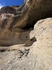
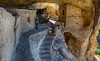
The Gila Cliff Dwellings are a group of stone cobble ruins of around 50 rooms are set into five separate caves within a cliff face. The ruins are attributed to the Mogollon culture (Mimbres branch or subgroup) and are dated to 1275 through 1300 AD. The ruins have been dated by core drilling wooden support beams used for door and windows, attribution of artifacts, and carbon dating.
From tree ring dating, the structures were built and occupied within a very short period; as little as 11 years.
Like the architecture of Ancestral Puebloan people farther north, Mongollon structures began with Pithouses, and later developments were surface pueblos and cliff dwellings. The Gila Cliff Dwellings were rediscovered in the modern era in the 1870's but were not protected by inclusion in the national park system until 1933. Their remote location and relatively small size compared to large, complex sites like those at Mesa Verde and Chaco culture sites resulted in few scientific or protective resources being applied until the 1950's and 1960's. Before this period the site had been extensively looted and vandalized.
These resulting depredations resulted in relatively little archaeological study compared to simply trying to preserve the structures. The only substantial modern publication on the archaeology of the site is The Archaeology of Gila Cliff Dwellings, 1987.
Today's visitor to the Gila Cliff Dwellings National Monument may see a small museum at a Visitor's Center before walking a mile long trail to the cliff dwellings.
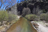
Today the site is within the Gila National Wilderness. It is a National Register of Historic Places site (#66000472):
Historic Significance: Information Potential, Architecture/Engineering
Area of Significance: Architecture, Prehistoric, Historic - Aboriginal
Cultural Affiliation: Archaic--Classic Mimbres
Historic Sub-function: Multiple Dwelling, Village Site
You may be viewing yesterday's version of this page. To see the most up to date information please register for a free account.
Do not use the above information on other web sites or publications without permission of the contributor.
Nearby Images from Flickr


The above images may not be of the site on this page, but were taken nearby. They are loaded from Flickr so please click on them for image credits.
Click here to see more info for this site
Nearby sites
Click here to view sites on an interactive map of the areaKey: Red: member's photo, Blue: 3rd party photo, Yellow: other image, Green: no photo - please go there and take one, Grey: site destroyed
Download sites to:
KML (Google Earth)
GPX (GPS waypoints)
CSV (Garmin/Navman)
CSV (Excel)
To unlock full downloads you need to sign up as a Contributory Member. Otherwise downloads are limited to 50 sites.
Turn off the page maps and other distractions
Nearby sites listing. In the following links * = Image available
69.1km NW 311° Cordova Cave* Cave or Rock Shelter
77.3km NNW 338° Tularosa cave* Cave or Rock Shelter
140.2km NW 318° Casa Malpais* Ancient Village or Settlement
156.7km ESE 120° Summerford Mountain Archaeology District Rock Art
174.2km NW 325° Table Rock Pueblo* Ancient Village or Settlement
178.2km WNW 292° Kinishba Ruins* Ancient Village or Settlement
187.1km ESE 104° Fossilized Footprints - White Sands National Park* Ancient Trackway
195.7km NNE 19° Acoma Pueblo Ancient Village or Settlement
200.6km NNW 341° Hawikku* Ancient Village or Settlement
201.3km N 358° Atsinna Pueblo* Ancient Village or Settlement
208.8km NNE 34° Los Lunas Decalogue Stone* Marker Stone
210.1km E 86° Three Rivers Petroglyphs* Rock Art
228.8km NW 320° Agate House* Ancient Village or Settlement
234.8km SE 137° Caballo Blanco de Juárez Hill Figure or Geoglyph
238.8km NW 324° Newspaper Rock (Petrified Forest)* Rock Art
239.7km W 271° Crow Canyon* Rock Art
239.7km NW 324° Puerco Pueblo Petroglyphs* Rock Art
239.7km NW 324° Puerco Pueblo.* Ancient Village or Settlement
245.0km N 4° Casamero* Ancient Village or Settlement
246.9km N 5° Blue J Ancient Village or Settlement
253.0km NNE 33° Petroglyph National Monument Rock Art
253.0km NNE 33° Petroglyph Nat. Mon.* Rock Art
254.5km SE 124° Hueco Tanks State Park & Historic Site* Rock Art
255.6km NE 36° Maxwell Museum of Anthropology* Museum
257.5km NNE 33° Boca Negra Canyon* Rock Art
View more nearby sites and additional images


 We would like to know more about this location. Please feel free to add a brief description and any relevant information in your own language.
 Wir möchten mehr über diese Stätte erfahren. Bitte zögern Sie nicht, eine kurze Beschreibung und relevante Informationen in Deutsch hinzuzufügen.
 Nous aimerions en savoir encore un peu sur les lieux. S'il vous plaît n'hesitez pas à ajouter une courte description et tous les renseignements pertinents dans votre propre langue.
 Quisieramos informarnos un poco más de las lugares. No dude en añadir una breve descripción y otros datos relevantes en su propio idioma.