

<< Our Photo Pages >> Hartwith Moor - Standing Stone (Menhir) in England in Yorkshire (North)
Submitted by DavidRaven on Sunday, 14 December 2003 Page Views: 8023
Neolithic and Bronze AgeSite Name: Hartwith MoorCountry: England
NOTE: This site is 2.855 km away from the location you searched for.
County: Yorkshire (North) Type: Standing Stone (Menhir)
Nearest Town: Harrogate Nearest Village: Summerbridge
Map Ref: SE2123362737 Landranger Map Number: 99
Latitude: 54.060148N Longitude: 1.677111W
Condition:
| 5 | Perfect |
| 4 | Almost Perfect |
| 3 | Reasonable but with some damage |
| 2 | Ruined but still recognisable as an ancient site |
| 1 | Pretty much destroyed, possibly visible as crop marks |
| 0 | No data. |
| -1 | Completely destroyed |
| 5 | Superb |
| 4 | Good |
| 3 | Ordinary |
| 2 | Not Good |
| 1 | Awful |
| 0 | No data. |
| 5 | Can be driven to, probably with disabled access |
| 4 | Short walk on a footpath |
| 3 | Requiring a bit more of a walk |
| 2 | A long walk |
| 1 | In the middle of nowhere, a nightmare to find |
| 0 | No data. |
| 5 | co-ordinates taken by GPS or official recorded co-ordinates |
| 4 | co-ordinates scaled from a detailed map |
| 3 | co-ordinates scaled from a bad map |
| 2 | co-ordinates of the nearest village |
| 1 | co-ordinates of the nearest town |
| 0 | no data |
Internal Links:
External Links:
")
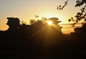
This un-named standing stone, Standing Stone Hill, North Yorks. The O.S. map for Nidderdale shows a 'Standing Stone Hill' just north of the village of Hartwith, near Summerbridge. Though any references to an actual stone are hard to come by. We followed the public footpath through Highfield farm and asked the farmer permission to wander his land looking for the stone. He was very amiable and gave us directions to it, telling us it was off the footpath in the middle of one of his pastures. On first sight, it reminded me of a miniature 'Devil's arrow', the huge stones further south-east. It possesses the same curious weathering, a 'fluting' at the top. The views west to the lofty Pennines are magnificent, the vast Vale of York lays to the east.
The Northern Antiquarian (TNA) also feature a page for this standing stone - see their entry for Hartwith Moor, Summerbridge, North Yorkshire, which gives directions for finding this site, photographs and a brief archaeology & history. TNA add: "Although just over 6-feet tall, this is a solid bulky old fella. But the spot he presently occupies isn’t his original standing place. He was found knocked over and lying on the ground in the middle of the 20th century, slightly out of position. But he was thankfully stood back upright by the local land-owners sometime in the 1960s, where he’s been stood ever since. It must have been one helluva job! And making it more difficult was the intriguing geological nature of the Earth right beneath this field. As the lady who now own the land told us, “When the fields were tilled we found that all of them were easy to turn over, except the one with the stone in it! There’s virtually no soil of any depth to write home about,” she said, 'It stands on only a few inches of soil and then you hit solid rock right underneath it. All the other fields are OK – but this one’s the odd one out.'"
You may be viewing yesterday's version of this page. To see the most up to date information please register for a free account.
")
")
")
")
")
")
")
")
")
")
")
")
Do not use the above information on other web sites or publications without permission of the contributor.
Click here to see more info for this site
Nearby sites
Key: Red: member's photo, Blue: 3rd party photo, Yellow: other image, Green: no photo - please go there and take one, Grey: site destroyed
Download sites to:
KML (Google Earth)
GPX (GPS waypoints)
CSV (Garmin/Navman)
CSV (Excel)
To unlock full downloads you need to sign up as a Contributory Member. Otherwise downloads are limited to 50 sites.
Turn off the page maps and other distractions
Nearby sites listing. In the following links * = Image available
1.5km N 355° Graffa Plain (Hartwith) Cairn (SE211642)
2.2km N 354° Brimham Rocks* Rock Outcrop (SE210649)
2.2km NNW 338° Brimham Rocks Rock Art Rock Art (SE2039764782)
2.4km NNW 344° Brimham Rocks Circle Stone Circle (SE20566507)
2.6km W 260° Bryan's Wood 01 Rock Art (SE1866362280)
2.7km WSW 258° Eastwoods Farm 02 (Heyshaw) Rock Art (SE1857262168)
2.7km W 260° Eastwoods Farm 01 (Heyshaw) Rock Art (SE1855662240)
2.7km W 259° Fertility Stone (CR-638)* Rock Art (SE1855262228)
2.8km WSW 255° Eastwoods Farm Cup (Heyshaw)* Rock Art (SE1852062010)
2.8km WSW 255° Eastwoods Cross Base (Summerbridge) Rock Art (SE1850662013)
2.8km WSW 251° Morphing Stone (Dacre)* Rock Art (SE1855961795)
2.8km WSW 248° Tadpole Stone (Eastwoods Rough)* Rock Art (SE1860161644)
2.9km WSW 251° Eastwoods Rough 3 (Dacre) Rock Art (SE18506177)
4.0km E 95° Cowgate Manor Barn (Shaw Mills) Rock Art (SE2525562397)
4.4km SW 230° Dacre Top* Ancient Village or Settlement (SE179599)
4.9km W 280° Guisecliff Wood (629)* Rock Art (SE1641563565)
5.0km W 276° Hayshaw Moor North (Dacre) Cairn (SE1621863253)
5.1km NNE 23° Wine Wife Well* Holy Well or Sacred Spring (SE23216742)
5.2km W 280° Guisecliff Wood (626)* Rock Art (SE1607863641)
5.6km ESE 107° Deb Well* Holy Well or Sacred Spring (SE266611)
7.0km NNW 344° Pateley Moor* Standing Stone (Menhir) (SE193695)
7.2km E 87° Cayton Gill carving* Modern Stone Circle etc (SE284632)
7.4km ESE 108° Weeping Cross* Ancient Cross (SE283605)
7.5km W 260° Abbot's Hand* Marker Stone (SE138614)
7.5km S 183° Long Stoop* Standing Stones (SE209552)
View more nearby sites and additional images


 We would like to know more about this location. Please feel free to add a brief description and any relevant information in your own language.
 Wir möchten mehr über diese Stätte erfahren. Bitte zögern Sie nicht, eine kurze Beschreibung und relevante Informationen in Deutsch hinzuzufügen.
 Nous aimerions en savoir encore un peu sur les lieux. S'il vous plaît n'hesitez pas à ajouter une courte description et tous les renseignements pertinents dans votre propre langue.
 Quisieramos informarnos un poco más de las lugares. No dude en añadir una breve descripción y otros datos relevantes en su propio idioma.