<< Our Photo Pages >> Giant's Grave (Hestinsetter Hill) - Chambered Cairn in Scotland in Shetland
Submitted by h_fenton on Sunday, 19 April 2015 Page Views: 2668
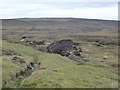
Neolithic and Bronze AgeSite Name: Giant's Grave (Hestinsetter Hill)Country: Scotland
NOTE: This site is 0.362 km away from the location you searched for.
County: Shetland Type: Chambered Cairn
Nearest Village: Easter Skeld
Map Ref: HU2919945702
Latitude: 60.194667N Longitude: 1.475234W
Condition:
| 5 | Perfect |
| 4 | Almost Perfect |
| 3 | Reasonable but with some damage |
| 2 | Ruined but still recognisable as an ancient site |
| 1 | Pretty much destroyed, possibly visible as crop marks |
| 0 | No data. |
| -1 | Completely destroyed |
| 5 | Superb |
| 4 | Good |
| 3 | Ordinary |
| 2 | Not Good |
| 1 | Awful |
| 0 | No data. |
| 5 | Can be driven to, probably with disabled access |
| 4 | Short walk on a footpath |
| 3 | Requiring a bit more of a walk |
| 2 | A long walk |
| 1 | In the middle of nowhere, a nightmare to find |
| 0 | No data. |
| 5 | co-ordinates taken by GPS or official recorded co-ordinates |
| 4 | co-ordinates scaled from a detailed map |
| 3 | co-ordinates scaled from a bad map |
| 2 | co-ordinates of the nearest village |
| 1 | co-ordinates of the nearest town |
| 0 | no data |
Internal Links:
External Links:
 (PID:131769)")
A badly ruined chambered cairn, barely recognisable as an ancient site, most of the stones have been removed. The cairn was excavated in 1866, the finds included pottery and cremated bone.
Canmore Description:http://canmore.rcahms.gov.uk/en/site/290/details/hestinsetter+hill+giant+s+grave/
You may be viewing yesterday's version of this page. To see the most up to date information please register for a free account.
Do not use the above information on other web sites or publications without permission of the contributor.
Nearby Images from Geograph Britain and Ireland:
©2013(licence)
©2013(licence)
©2013(licence)
©2008(licence)
©2019(licence)
The above images may not be of the site on this page, they are loaded from Geograph.
Please Submit an Image of this site or go out and take one for us!
Click here to see more info for this site
Nearby sites
Key: Red: member's photo, Blue: 3rd party photo, Yellow: other image, Green: no photo - please go there and take one, Grey: site destroyed
Download sites to:
KML (Google Earth)
GPX (GPS waypoints)
CSV (Garmin/Navman)
CSV (Excel)
To unlock full downloads you need to sign up as a Contributory Member. Otherwise downloads are limited to 50 sites.
Turn off the page maps and other distractions
Nearby sites listing. In the following links * = Image available
2.5km SSE 161° Yahaarwell* Standing Stone (Menhir) (HU30054332)
2.8km S 171° Hoddans Chambered Cairn (HU29684293)
3.0km S 184° Ward of Silwick Chambered Cairn (HU29004267)
4.0km WSW 257° Culswick Broch* Broch or Nuraghe (HU253448)
4.5km N 355° Stanydale Neolithic house* Ancient Village or Settlement (HU28785019)
4.6km N 352° Stanydale standing stones* Standing Stones (HU28525021)
4.6km N 352° Stanydale* Stone Circle (HU2853450242)
6.1km NW 325° Gallow Hill Cairn* Cairn (HU25715067)
6.1km NNW 327° Gallow Hill chambered cairn* Chambered Cairn (HU2581850821)
6.3km NE 38° Semblister Stone Circle* Stone Circle (HU3307450733)
6.5km NW 310° Kirkidale Standing Stone* Standing Stone (Menhir) (HU24214984)
6.7km NE 47° Semblister Broch or Nuraghe (HU341503)
6.9km NNW 329° Scord of Brouster* Ancient Village or Settlement (HU25605165)
7.3km NW 324° Cattapund Knowe cairn* Cairn (HU2480851533)
7.3km NW 321° Hansie's Crooie Field System* Ancient Village or Settlement (HU24545133)
7.4km NW 321° Hansies Crooie* Chambered Cairn (HU24485147)
8.1km NW 323° Loch Of Flatpunds* Chambered Cairn (HU24305219)
8.2km NW 325° Trolligarts 1* Chambered Cairn (HU24415243)
8.3km WNW 293° Stanesland standing stone* Standing Stone (Menhir) (HU21524889)
8.4km NW 325° Trolligarts 2* Chambered Cairn (HU24275249)
9.6km E 95° Easthouse* Standing Stones (HU388450)
10.0km NW 325° Burga Water Dun* Stone Fort or Dun (HU234539)
10.4km NW 324° Burga Water cairn* Cairn (HU22975407)
10.6km NNE 19° Gravlaba* Standing Stones (HU325558)
11.3km ESE 112° Loch of Houlland Ancient Village or Settlement (HU39754161)
View more nearby sites and additional images


 We would like to know more about this location. Please feel free to add a brief description and any relevant information in your own language.
 Wir möchten mehr über diese Stätte erfahren. Bitte zögern Sie nicht, eine kurze Beschreibung und relevante Informationen in Deutsch hinzuzufügen.
 Nous aimerions en savoir encore un peu sur les lieux. S'il vous plaît n'hesitez pas à ajouter une courte description et tous les renseignements pertinents dans votre propre langue.
 Quisieramos informarnos un poco más de las lugares. No dude en añadir una breve descripción y otros datos relevantes en su propio idioma.