<< Our Photo Pages >> St Luke (Hickling) - Early Christian Sculptured Stone in England in Nottinghamshire
Submitted by Thorgrim on Monday, 26 December 2005 Page Views: 6305
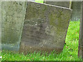
Early Medieval (Dark Age)Site Name: St Luke (Hickling)Country: England
NOTE: This site is 7.511 km away from the location you searched for.
County: Nottinghamshire Type: Early Christian Sculptured Stone
Nearest Town: Nottingham Nearest Village: Hickling
Map Ref: SK691292
Latitude: 52.855868N Longitude: 0.975226W
Condition:
| 5 | Perfect |
| 4 | Almost Perfect |
| 3 | Reasonable but with some damage |
| 2 | Ruined but still recognisable as an ancient site |
| 1 | Pretty much destroyed, possibly visible as crop marks |
| 0 | No data. |
| -1 | Completely destroyed |
| 5 | Superb |
| 4 | Good |
| 3 | Ordinary |
| 2 | Not Good |
| 1 | Awful |
| 0 | No data. |
| 5 | Can be driven to, probably with disabled access |
| 4 | Short walk on a footpath |
| 3 | Requiring a bit more of a walk |
| 2 | A long walk |
| 1 | In the middle of nowhere, a nightmare to find |
| 0 | No data. |
| 5 | co-ordinates taken by GPS or official recorded co-ordinates |
| 4 | co-ordinates scaled from a detailed map |
| 3 | co-ordinates scaled from a bad map |
| 2 | co-ordinates of the nearest village |
| 1 | co-ordinates of the nearest town |
| 0 | no data |
Internal Links:
External Links:
 (PID:9999)")
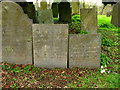
This is one of a number of Saxon and Viking grave covers found in the area
You may be viewing yesterday's version of this page. To see the most up to date information please register for a free account.
Do not use the above information on other web sites or publications without permission of the contributor.
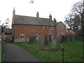
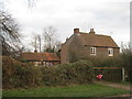
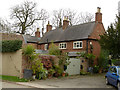
Nearby Images from Geograph Britain and Ireland:
©2012(licence)
©2012(licence)
©2015(licence)
©2015(licence)
©2015(licence)
The above images may not be of the site on this page, they are loaded from Geograph.
Please Submit an Image of this site or go out and take one for us!
Click here to see more info for this site
Nearby sites
Key: Red: member's photo, Blue: 3rd party photo, Yellow: other image, Green: no photo - please go there and take one, Grey: site destroyed
Download sites to:
KML (Google Earth)
GPX (GPS waypoints)
CSV (Garmin/Navman)
CSV (Excel)
To unlock full downloads you need to sign up as a Contributory Member. Otherwise downloads are limited to 50 sites.
Turn off the page maps and other distractions
Nearby sites listing. In the following links * = Image available
2.8km S 183° Woundheal Spring* Holy Well or Sacred Spring (SK690264)
3.7km ESE 124° Long Clawson Stone* Standing Stone (Menhir) (SK722272)
4.8km SSE 147° Clawson Hose and Harby Cursus Cursus (SK718252)
6.1km SE 145° Holwell Mouth* Holy Well or Sacred Spring (SK7269324230)
6.5km SE 130° Hazeltongue Lodge Henge (SK74092509)
7.1km SSE 153° Ab Kettleby* Holy Well or Sacred Spring (SK724229)
7.3km S 186° Grimston Church Monolith* Standing Stone (Menhir) (SK685219)
7.4km S 186° Grimston Stone* Standing Stone (Menhir) (SK684218)
8.1km NNW 347° Stragglethorpe Bronze Age ring ditch* Round Barrow(s) (SK6720037057)
8.4km S 170° Saxelbye Stone* Standing Stone (Menhir) (SK707210)
9.8km SSW 199° Ragdale Stone* Standing Stone (Menhir) (SK661199)
10.3km S 171° Asfordby Cross* Ancient Cross (SK7078419006)
10.4km S 171° All Saints (Asfordby)* Ancient Cross (SK7081218939)
10.4km WSW 237° Wymeswold Stone* Standing Stone (Menhir) (SK604234)
11.5km S 179° Frisby Cross Ancient Cross (SK6942017659)
12.1km SSW 192° Hoby Stone Standing Stone (Menhir) (SK667173)
12.2km S 178° Stump Cross (Frisby on the Wreake) Ancient Cross (SK6969917032)
12.3km N 4° Old Wark Spring* Holy Well or Sacred Spring (SK698415)
12.3km ENE 60° St Peter's Church (Redmile)* Early Christian Sculptured Stone (SK7971335528)
12.5km N 3° Shelford and Newton Cursus Cursus (SK696417)
14.5km SSE 148° Burton Lazars Stockwell* Holy Well or Sacred Spring (SK770170)
14.9km E 81° St Michael and All Angels (Harston)* Ancient Cross (SK8384031774)
15.1km NE 51° Bottesford Cross* Ancient Cross (SK8061638944)
15.2km SSW 196° Blue Stone (Rearsby)* Natural Stone / Erratic / Other Natural Feature (SK6497414518)
15.5km WNW 297° Clifton Pile Settlements* Ancient Village or Settlement (SK5513735946)
View more nearby sites and additional images


 We would like to know more about this location. Please feel free to add a brief description and any relevant information in your own language.
 Wir möchten mehr über diese Stätte erfahren. Bitte zögern Sie nicht, eine kurze Beschreibung und relevante Informationen in Deutsch hinzuzufügen.
 Nous aimerions en savoir encore un peu sur les lieux. S'il vous plaît n'hesitez pas à ajouter une courte description et tous les renseignements pertinents dans votre propre langue.
 Quisieramos informarnos un poco más de las lugares. No dude en añadir una breve descripción y otros datos relevantes en su propio idioma.